…A Winter Storm Warning Remains in Effect until 6 am Thursday for the Hill Country and most of Central Texas…
Widespread rain developed and spread northeast across the region late Tuesday night into Wednesday morning. Radar estimates show the heaviest rain fell across the Interstate 35 corridor between San Antonio, Austin, and Temple. Here rain amounts were generally between 0.75 and 1.25 inches. For the rest of the region, most totals were generally around a quarter inch or less. With temperatures below freezing, the rain became freezing rain, with most of the area seeing significant ice accumulations. National Weather Service reports widespread ice accumulations of between a tenth of an inch and a half inch across much of the area. There were a several totals close to two thirds of an inch. In Austin, Camp Mabry recorded a 2-day ice accumulation close to two thirds of an inch at 0.63 inch.
The winter storm is not over with yet. As of mid-afternoon Wednesday, the temperature was at or below freezing north of a line stretching from Caldwell, to Bastrop, to Boerne. Little change in the temperatures is expected through the evening and overnight hours. Intermittent light rain has been falling across the area throughout the afternoon and this is expected to continue through late evening, leading to additional light freezing rain—especially across the Hill Country.
Forecasters are watching a trough of low pressure located over the northern Gulf of California. The trough is predicted to track east across northern Mexico overnight, then bend northeast across northern Texas on Thursday. Rain showers and even some isolated thunderstorms are forecast to develop across West Texas late this evening in advance of the approaching trough of low pressure. Light to moderate rain is forecast to spread east to the Hill Country around midnight, and to Central Texas and the I-35 corridor in the hours just after midnight. The rain is forecast to continue through Thursday morning, then taper off from west to east midday through late afternoon. Widespread rain and freezing rain is forecast late Wednesday night through Thursday morning. Expect additional ice accumulations to total between a tenth and quarter inch, with some isolated accumulations to a half inch. Travel is expected to remain hazardous and treacherous through Thursday morning.
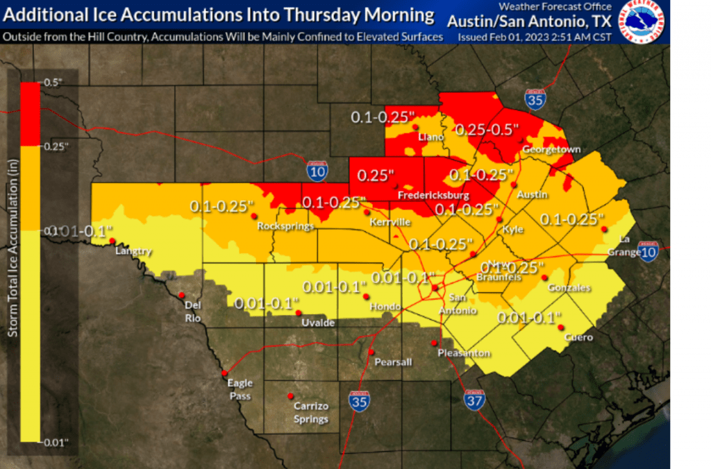
Liquid rain amounts overnight and through Thursday morning are forecast to generally average between a tenth and a third of an inch.
Somewhat milder air is predicted to spread into the area from the east beginning after sunrise Thursday. Forecasts call for the temperature to rise above freezing in the Austin area and across the I-35 corridor just after daybreak, and should warm above freezing across the Hill Country sometime late Thursday morning and toward noon. The threat for freezing rain and wintery weather will come to an Thursday morning as the temperature warms above freezing. Milder temperatures will develop Thursday afternoon as the precipitation comes to an end. Readings are forecast to warm to the low 40s across the Hill country, the mid-40s across Central Texas, and the upper 40s across the coastal plains.
Clouds will clear Thursday evening, allowing for freezing temperatures to develop. Lows Friday morning will include the upper 20s across the Hill Country, the low 30s across Central Texas, and the mid to upper 30s towards the coast. Friday’s weather will be sunny with temperatures climbing close to 50 degrees.
Expect one more freeze Friday night. Lows Saturday morning will include the upper 20s across the Hill Country, around 30 degrees across Central Texas, and the mid-30s across the coastal plains.
Mostly sunny and warmer weather is forecast this weekend, with high temperatures in the 50s on Saturday and into the 60s on Sunday. Lows will be in the 40s.
The next chance for rain is predicted to occur late Tuesday into Wednesday.
Bob
Social Media