…A Winter Storm Warning is in Effect for all of the Hill Country, plus Travis, Williamson, Bastrop, Hays, Lee, Comal, Caldwell, and Guadalupe Counties through noon Wednesday…
Overnight and morning assessments of the weather indicates the threat for wintery weather has increased. Forecasts are now pointing toward a significant icing event with major impacts for the Hill Country and the Interstate 35 corridor—including the Austin metropolitan area Monday night through Wednesday morning.
As of late Monday morning, the temperature was at or below freezing across the Hill Country, extending east to Interstate 35 and the Austin area. Readings were in the mid- 30s between Bastrop and La Grange and in the low to mid-40s across the coastal plains. The freezing line is not forecast to shift much further to the southeast this afternoon and the temperature should hold fairly steady. Radar and surface reports indicate a weak overrunning pattern is beginning to take shape across the Hill Country and Central Texas. Radar shows light precipitation spread north over the Hill Country and the Austin area and this is expected to continue throughout the afternoon. With temperatures at or below freezing, the light rain and drizzle may form a light glaze of ice along elevated roadways in the Austin area, across the Hill Country and parts of Central Texas.
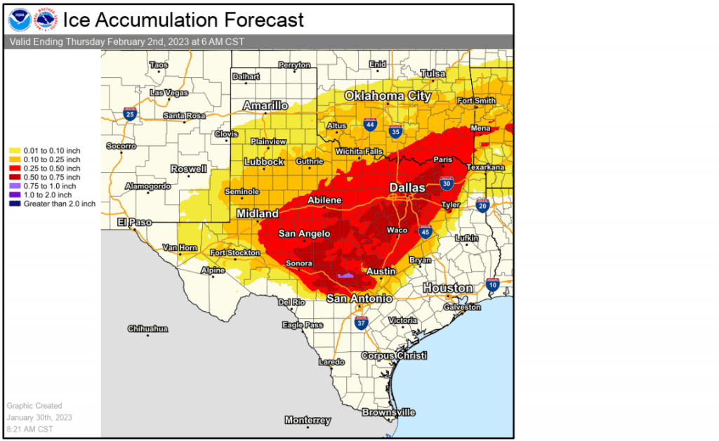
High-resolution forecasts call for the precipitation to increase in areal coverage late this evening, with waves of light precipitation continuing overnight and through much of the day Tuesday and Tuesday night. The temperature is forecast to remain at or below freezing across the Hill Country and the Interstate 35 corridor throughout the day Tuesday, Tuesday night, and into Wednesday morning. With much of the precipitation expected to freeze, significant ice accumulations are expected across the Hill Country and the Austin metropolitan area! Forecasts call for ice accumulations between a quarter and a half inch through Wednesday morning. Travel conditions across the area are forecast to become hazardous. The National Weather Service is discouraging non-emergency travel across the warned area Tuesday through Wednesday morning. Power line and tree branches may become weighted down by accumulating ice, resulting in power outages.
NWS Ice Accumulation Forecast for the Period Ending 6 am Thursday morning:

There is some potential the freezing temperatures could extended a bit further east and southeast to include Fayette Counties. A Winter Weather Advisory has been issued for Fayette County until noon Wednesday where ice accumulation up to a tenth of an inch will be possible.
Temperatures are forecast to warm above freezing across the region Wednesday afternoon and this should end the threat for freezing precipitation. Expect high temperatures in the mid-30s across the Hill Country, and in the upper 30s across Central Texas. Near steady temperatures are forecast Wednesday night.
Wednesday afternoon through Thursday morning, widespread rain and scattered thunderstorms are forecast across the region as a large upper trough of low pressure moves over the state. Rain amounts of 1-2 inches are forecast across the area. The rain is predicted to end from west to east Thursday morning into Thursday afternoon.
Sunny and dry weather is forecast Friday and through the weekend. Expect a light freeze Friday morning, with milder temperatures over the weekend.
Bob


Social Media