Weather Highlights
- No substantial rain is forecast over the next week
- A cold front will push across the area Saturday morning bringing drier air, breezy conditions, and cooler temperatures Saturday afternoon through Monday morning
- Frost and possible light freezes will be possible across the Hill Country Sunday and Monday mornings
- Elevated to critical fire weather conditions are forecast Saturday and Sunday
- Elevated to critical fire weather conditions are also forecast Wednesday and again next Friday
Discussion
The weather pattern is expected to stay active over the next couple of weeks, with a series of storm systems expected to push east across the southern Plains. Unfortunately, atmospheric conditions aren’t looking favorable for the development of any substantial rain with any of these systems. Each system is expected to bring windy conditions to much of the area. This will likely keep elevated fire weather conditions in place through most of next week.
Friday’s weather is expected to be mostly sunny and very spring-like as warmer and more humid air spreads north from the Gulf. High temperatures are predicted to generally be in the low and mid-80s. Lows Saturday morning will range from the mid-50s across the Hill Country, to the mid-60s across the coastal plains. Winds speeds are expected to be in the range of 5-10 mph.
Changes in the weather will take place Saturday as a trough of low pressure pushes east from the Desert Southwest. The trough is forecast to reach the Texas South Plains Saturday morning and the Red River Vally late Saturday into Sunday. The trough will help push a cold front across Texas Saturday morning into Saturday afternoon. The front is forecast to sweep across the Hill Country in the hours just before and after sunrise, reaching the Austin/Interstate 35 corridor mid-morning. The front should push off the middle Texas coast around mid-afternoon. A few light rain showers or isolated thunderstorms may occur across the northern half of the Hill Country and the northern counties of Central Texas (including Austin) when the front moves across the area. Rain amounts, if any, should total less than a tenth of an inch. For most of Central Texas and the middle Texas coast, no rain is forecast with the cold front.
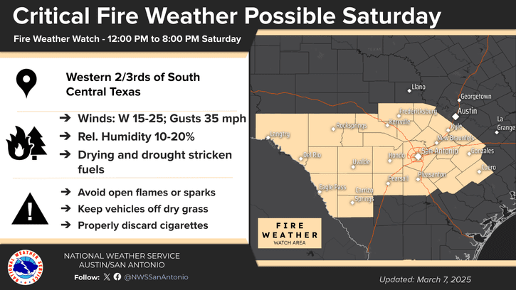
Breezy northwesterly winds with speeds of 10-20 mph and and much drier air will follow the cold front Saturday. The combination of breezy conditions and very dry air on Saturday will lead to elevated fire weather conditions across the region. The National Weather Service is pinpointing the western two-thirds of Central Texas and the southern Hill Country where somewhat stronger winds may cause critical fire weather conditions. A Fire Weather Watch has been posted for this area through 8 pm Saturday. A Fire Weather Watch is issued for areas where developing fires could be difficult to control and could spread rapidly.
Northwesterly winds with gusts to near 30 mph are forecast Sunday. With dry air in place, elevated to near critical fire weather conditions will continue—especially for areas across the Hill Country.
Everyone is urged to avoid any outdoor activities Saturday and Sunday that could inadvertently cause wildfires.
Cooler air will spread into the area behind the cold front Saturday afternoon and continue through Sunday night. In fact, frost and some light freezes will be possible across parts of the Hill Country Sunday and Monday mornings. Expect a mostly clear to partly cloudy sky Saturday afternoon through Sunday.
- Saturday’s afternoon’s temperature is forecast to fall into the 60s across the Hill Country and Central Texas regions, and into the 70s across the coastal plains
- Lows Sunday morning will include the upper 30s across the Hill Country, the low 40s across Central Timmerman, and mid-40s towards the coast
- High temperatures Sunday are forecast to generally be in the low 60s
- Lows Monday morning are predicted to be in the low and mid-30s across the Hill Country, the upper 30s to low 40s across Central Texas, and the low 40s coastal plains
Sunny and warmer weather will return Monday into Tuesday as southerly breezes establish. Fire weather concerns should abate some Monday and Tuesday as humidity levels slowly increase. However, wind speeds are forecast to increase back to 10-20 mph on Tuesday. High temperatures are forecast to be in the low 70s Monday, warming to the upper 70s Tuesday. Lows Tuesday morning are forecast to be in the low and mid-40s. Lows Wednesday morning are forecast to be in the 50s.
Forecasts call for another trough of low pressure to eject from the Desert Southwest to the southern Plains states late Tuesday into Wednesday. This system is expected to push another dry cold front across the area Wednesday morning, bringing more dry and strong westerly winds for Wednesday afternoon. Elevated to critical fire weather conditions are predicted to develop across the entire region Wednesday. High temperatures Wednesday are forecast to be in the low and mid-80s.
Sunny and very warm weather is forecast next Thursday and Friday in the wake of the departing storm system. High temperatures both days are predicted to be near 90 degrees.
Forecasters are closely monitoring weather developments for next Friday and Saturday when a large and even stronger trough of low pressure is forecast to push east out of northern Mexico and the Desert Southwest. Unfortunately, little to no rain is expected with the system. However, very windy conditions are forecast to develop across the region—possibly similar to what our region experienced last Tuesday. The strong winds and dry air will likely cause critical fire weather conditions to develop next Friday and Saturday. Stay tuned for more details as the forecast solutions get a better handle on this storm system.
The outlook for the week of March 17th calls for continued mild temperatures with highs in the 70s to low 80s.
Time Change Weekend
Daylight Saving Time begins Sunday, March 9th, at 2 am. Remember to “spring forward”, setting all clocks ahead one hour before going to bed Saturday night. Evenings will contain more daylight and early mornings will be a bit darker after the time change.
Have a good weekend!
Bob
Social Media