The heatwave and dry pattern continue. More triple-digit heat can be expected this week. But for the first time in a long while, there are beginning to be some signs of a little change to the persistent hot and dry pattern that will could take place over the next couple of weeks. The heat should begin to moderate down a few degrees next week and at the same time, a slight chance for a few showers will enter the forecast. These will not be drastic changes, but at least they will be a step in the right direction.
This afternoon will again be sunny and very hot. High temperatures are forecast to be between 103 and 107 degrees across Central Texas, and between 99 and 103 degrees across the coastal plains.
A weak cold front has pushed south into North Texas. As of early Monday afternoon, the front stretched from just east of Dallas, to near Brownwood, to south of Midland. The front is pushing slowly to the south-southeast by a fairly strong area of high pressure located over the Plains states. The front is expected to reach the northern Hill Country late this afternoon, the Austin and Central Texas area Tuesday morning, and the middle Texas coast Tuesday evening. Weak moisture convergence along the cold front may spark a couple of isolated showers and thunderstorms across parts of the northern Hill Country late this afternoon, and evening, and across Central Texas Tuesday into Tuesday evening. The probability for rain at any given location will be less than 20 percent. And for spots that do happen to see rain, totals are forecast to average less than a tenth of an inch. The chance for rain will diminish late Tuesday.
Just slightly cooler air can be expected behind the cold front.
- High temperatures Tuesday and Wednesday will include the upper 90s to low 100s across the Hill Country, near 102 to 104 degrees across Central Texas, and between 98 and 103 degrees across the coastal plains.
- Low temperatures Tuesday and Wednesday mornings are forecast to cool slightly in the low and mid-70s across the Hill Country, with mid to upper 70s at most other locations.
The cold front is forecast to wash out and lift back to the north late Wednesday. Meanwhile, the center of the heat dome is forecast to shift east toward Central Texas late week. This is expected to cause temperatures to return to extreme levels.
- High temperatures Thursday and Friday are predicted to be between 105 and 108 degrees across the Hill Country and Central Texas regions, and between 98 and 103 degrees across the coastal plains.
The weather is forecast to remain sunny, dry, and hot this weekend. High temperatures are predicted to be a couple of degrees lower as the center of the heat dome shifts north toward the central and southern Plains.
The outlook for next week calls for the center of the heat dome to remain across the middle Mississippi Valley region through Friday. It is then forecast to relocate over the Desert Southwest next weekend. With the center of the heat dome positioned well up to the northeast, it will allow for a broad easterly wind flow to develop off the Gulf of Mexico. This type of setup can often bring weak troughs of low pressure and enhanced areas of tropical moisture inland from the Gulf of Mexico, resulting in the development of widely scattered afternoon showers and thunderstorms. Forecast modeling cannot pinpoint these features just yet, but forecasts do point to a slight chance for a few showers next week. Rain amounts are not expected to be very heavy.
High temperatures next week are forecast to moderate down about 2-4 degrees as the center of the heat dome pulls up to the north.
- High temperatures next week are forecast to be between 100 and 104 degrees across the Hill Country and Central Texas regions, and between 97 and 100 degrees across the coastal plains.
Similar conditions are forecast for the following weekend.
Fire Weather Potential
Elevated to Near-Critical Fire Weather can be expected across the Hill Country and Central Texas regions this week. The combination of critically to extremely dry fuels, breezy winds, and low afternoon humidity will continue to support wildfires with high resistance to control, per guidance from the Texas A&M Forest Service.
Affected residents are urged to exercise care with respect to all outdoor activities that could inadvertently cause wildfires. Avoid the use of welding or grinding equipment near grass and dry brush. In addition, avoid parking vehicles in tall, dry grass and weeds that could be ignited. Do not toss cigarette butts on the ground. Report wildfires quickly to the nearest fire department or law enforcement office.
Tropical Weather Update
Weather conditions remain quiet across the Gulf of Mexico and the Caribbean Sea. There are no systems here that pose a threat for tropical development through late week.
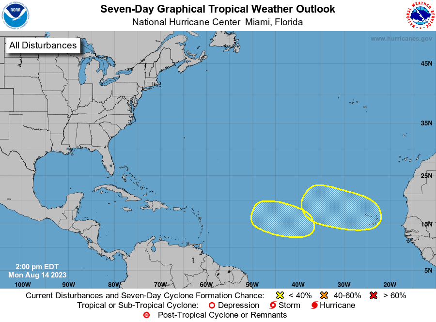
Out in the eastern tropical Atlantic, the National Hurricane Center is monitoring two potential systems.
A tropical wave is forecast to move off the west coast of Africa on Wednesday or early Thursday. Some slow development of this system will be possible late this week or over the weekend while the system moves gradually west-northwestward or northwestward across the eastern Atlantic. The probability for tropical development over the next seven days is near 30 percent.
Another area of low pressure could develop by the middle to late week over the central tropical Atlantic. Some slow development of this system will be possible while it moves west-northwestward through the end of the week. The probability for development over the next seven days is near 20 percent.
Have a good week.
Bob
Social Media