Weather conditions are breezy and slightly cooler today, following the passage of a Pacific cold front late Thursday night. There was no rain with the front. A strong pressure gradient today will cause breezy northwesterly winds of 10-20 mph, with gusts to 35 mph through late afternoon. The gusty winds and very dry air will lead to elevated to near critical fire weather conditions through late afternoon (See the Fire Weather section below). Wind speeds are predicted to decrease this evening and become light after midnight. Under a sunny sky, this afternoon’s temperature is forecast to warm to near 70-72 degrees.
The combination of a clear sky, light winds, and dry air will allow the temperature to become rather chilly overnight. Lows Saturday morning will include the mid and upper 30s across the Hill Country, with low 40s at most other locations.
Weekend weather conditions are looking to be sunny and quite pleasant! Surface high pressure over Texas will shift off to the east Saturday afternoon, causing a return of southerly breezes. Light winds are forecast Saturday and Saturday night, followed by wind speeds of 10-20 mph on Sunday. This is expected to cause elevated fire weather conditions. High temperatures both days are predicted to be in the upper 70s. Lows Sunday morning will generally be in the mid-40s.
The chance for rain showers and isolated thunderstorms will begin to increase after midnight Sunday night. Forecasters are monitoring a potent trough of low pressure currently located over the Gulf of Alaska that is tracking to the southeast. The trough is predicted to reach the Pacific coast late Saturday, move across the southern Rockies and Desert Southwest Sunday and then across the northern half of Texas Monday into Tuesday. In advance of the approaching trough, Gulf moisture will begin streaming north into our region late Sunday night, causing the atmosphere to become increasingly moist and unstable.
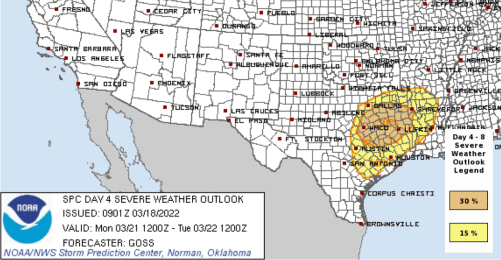
Widespread rain showers and scattered thunderstorms are forecast across the region Monday morning through Monday night in advance of a dry line pushing east out of West Texas. The threat for strong to severe storms will increase across the area Monday afternoon through Monday night as the atmosphere becomes increasingly unstable and at the same time the dry line and a Pacific cold front move across the area. The Storm Prediction Center’s updated severe weather outlook is now calling for the highest probability for severe storms to occur over the area along and to the east of Interstate 35, with a lesser chance for severe storms across the Hill Country. The outlook shows the very highest probability for severe storms to occur to the northeast of Austin, extending northeast to Dallas, Shreveport and Lufkin. All hazards of severe storms will be possible Monday. Very large hail and damaging winds with be the primary threats along with the risk for a few tornadoes.
SPC Severe Weather Outlook for Monday:
The thunderstorm threat will diminish from west to east late Monday night into early Tuesday morning as the Pacific cold front brings in drier and more stable air.
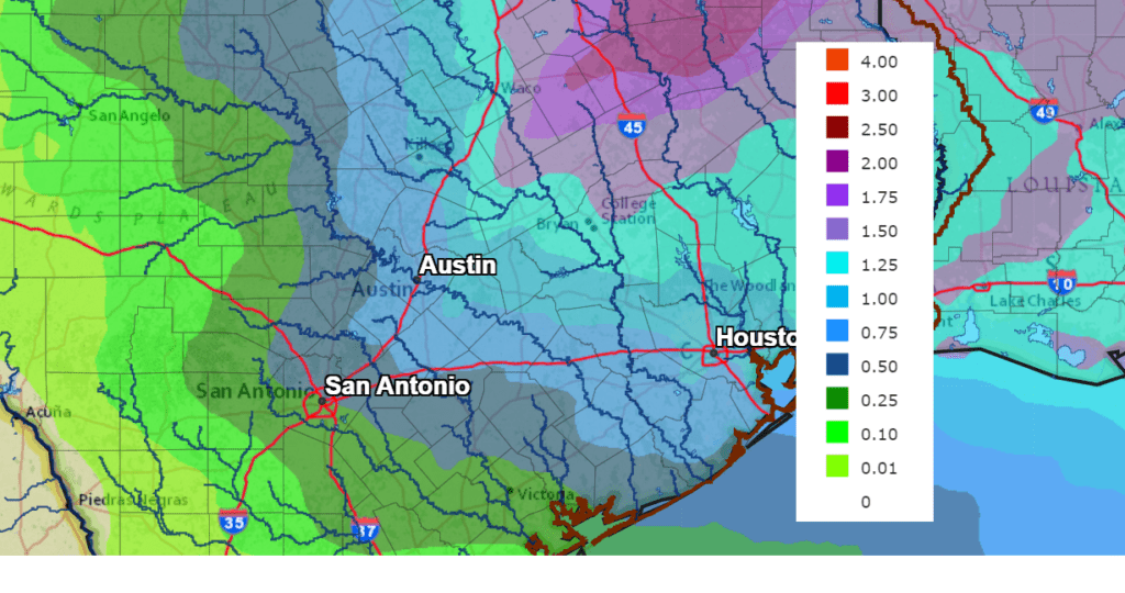
Rain amounts are forecast to be heaviest for areas generally along and to the east of the Interstate 35 corridor. The National Weather Service is predicting totals of 0.25-0.5 inches for the western Hill Country. Totals across the eastern Hill Country, Central Texas and the middle Texas coast are predicted to be in the range of 0.75 to 1.5 inches.
NWS Rainfall Forecast for the Period 7 pm Friday through 7 pm Wednesday:
Sunny and dry weather is forecast Monday afternoon, continuing through late next week as the atmosphere over our area becomes quit dry and stable. After highs in the low to mid-80s Monday, readings are forecast to trend a little cooler into the upper 60s next Tuesday through Thursday. Lows Tuesday morning will be in the upper 40s to low 50s. Lows Wednesday and Thursday mornings will range from the upper 30s across the Hill Country, to the upper 40s across the coastal region.
Sunny, dry, and warmer weather is forecast for next Friday and next weekend. High temperatures are predicted to be in the upper 70s to low 80s, with low temperatures in the low 50s.
Looking out into the week of March 28th, generally dry and mild weather looks to continue.
Fire Weather
Elevated to near critical fire weather conditions are expected area wide this afternoon due to the strong winds and low relative humidity levels.
A few spots may have a brief period of critical fire weather conditions.
Elevated to near critical fire weather conditions are expected again on Sunday as strong winds return to the region.
The Start of Spring
The Vernal Equinox will occur this Sunday, March 20th, at 10:33 am CDT. At the equinox, Earth’s two hemispheres are receiving the sun’s rays equally. Night and day are often said to be equal in length. In fact, the word equinox comes from the Latin aequus (equal) and nox (night). For our ancestors, whose timekeeping was less precise than ours, day and night likely did seem equal. The sun will rise due east and sets due west at the equinox.
Have a great weekend!
Bob
Social Media