Extreme Heat and No Rain Persisting through Next Week
July 28, 2023
Our summer of extreme heat and little to no rain continues. The temperature so far this month has been averaging between 3 and 5 degrees above normal. Rainfall has been well below normal, with the majority of Central Texas receiving less than a tenth of an inch. Texas summers can often be rough, but this summer is ranking among some of the roughest on record thanks to an unusually strong and persistent heat dome.
Friday’s weather maps showed the heat dome covering the southwestern, south central and southeastern U.S. For the past couple of days, the center of the heat dome has been centered to the west of Texas, between Albuquerque and Phoenix. This increased distance from the center has allowed afternoon temperatures to be about 1-3 degree lower than they were earlier in the week.
Forecast solutions call for the center of the heat dome to remain west of our region this afternoon and Saturday. As a result, high temperatures both days are predicted to be very similar to what was observed Wednesday and Thursday. The air mass over the region is not overly humid. As a result, heat index readings are forecast to be just slightly higher than the actual air temperature.
- High temperatures Friday and Saturday are predicted to be near 101-104 degrees across the Hill Country and Central Texas regions, and near 98-100 degrees across the coastal plains.
Beginning Sunday, the center of the heat dome is forecast to slowly shift east, moving from Arizona to New Mexico, the Texas Panhandle, and finally Oklahoma. Next Thursday and Friday, the dome center is predicted to be over eastern Oklahoma and northeast Texas. With the dome center moving closer to our area next week, high temperatures are forecast to rise 2-3 degrees.
- High temperatures Sunday through Tuesday are forecast to be near 102-105 degrees across the Hill Country and Central Texas regions, and near 98-101 degrees across the coastal plains.
- High temperatures Wednesday through Friday are forecast to be near 103-107 degrees across the Hill Country and Central Texas regions, and near 98-102 degrees across the coastal plains.
There are presently no Heat Advisories posted across the region. However, with increasing temperatures and humidity levels next week, Heat Advisories can be expected to be issued for most of the area.
A few widely scattered sea-breeze rain showers and thunderstorms will be possible for areas located south of Interstate 10 Friday and Saturday. The probability for rain at best will be 20 percent. Aside from this outside chance for rain across the coastal plains, no rain is forecast across the region through late next week.
Looking Ahead
Friday’s longer-range forecast data shows little change in the weather pattern next weekend and through the second week of August. Forecasts call for the center of the heat dome returning Arizona and New Mexico and remaining over the area through the middle of the month.
High temperatures are forecast to hold near 103-106 degrees.
Aside from a few sea breeze showers near the coast, no rain is forecast.
Tropical Weather Outlook
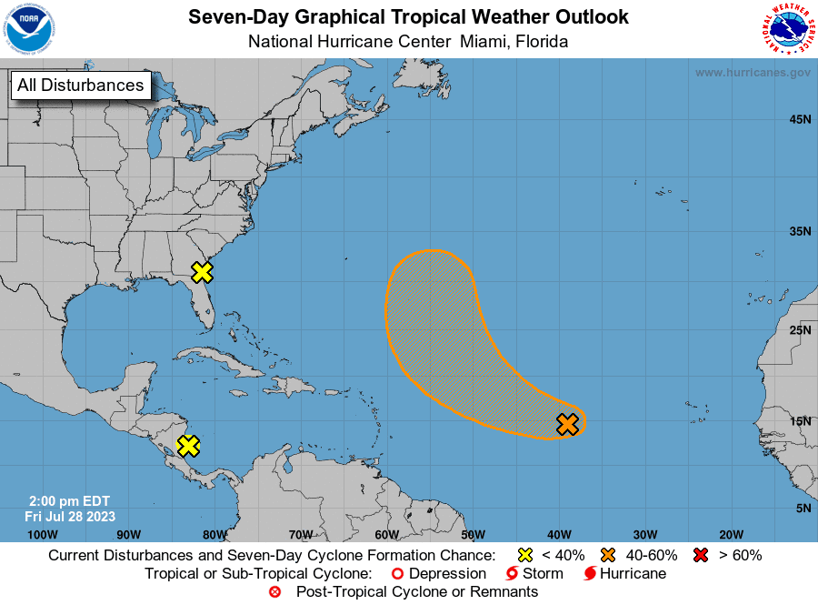
There are currently no systems of interest that have the potential to affect the Gulf of Mexico over the next several days.
National Hurricane Center forecasters are tracking a large area of disorganized showers and thunderstorms over the southwestern Caribbean Sea. These showers are associated with the tropical wave and low pressure area which moved across the Caribbean earlier this week. This system is forecast to move westward over Central America later today or tonight, and poses no threat for development in the Gulf.
NHC forecasters are monitoring and area of disorganized showers and thunderstorms over the far western Atlantic near the coasts of Georgia and northeastern Florida. These showers and storms are associated with a weak area of low pressure that has formed just east of Jacksonville. This system is moving north-northwestward and is forecast to move inland over northeastern Florida and eastern Georgia today, and additional development is not expected.
Out across the central tropical Atlantic, NHC forecasters are following a tropical wave located about midway between the Cabo Verde Islands and the Lesser Antilles. Showers and thunderstorms associated with the wave have increased since yesterday and environmental conditions are expected to be favorable for gradual development of this system during the next few days. A tropical depression could form early next week. The system is expected to follow a break in the subtropical ridge and to turn west-northwestward toward Bermuda, staying north of the Gulf of Mexico. NHC forecasters are giving this system a medium, or 60 percent chance for tropical development over the next seven days.
An Elevated Fire Weather Will Continue through Next Week
With the heat dome firmly settled over the region, no rain is forecast at least through he end of next week. Worsening drought conditions, increasingly dry fuels, and low afternoon relative humidity levels will bring a high fire danger to the Hill Country and Central Texas regions and medium fire danger to the coastal plains region through the weekend and much of next week.
Texas A&M Forest Service Forecast Fire Danger:

Bob
Social Media