Very moist air spreading north from the Gulf produced very beneficial rains across much of the area late Wednesday through Thursday night. While parts of the area saw totals of close to 2 inches, the highest totals from this rain event occurred across Deep South Texas, to the south of Laredo and Corpus Christi, where there were widespread 5 to 8 inch totals. Intense rains produced storm totals of 15-20 inches along the urban corridor between McAllen and Brownsville, resulting in catastrophic flash flooding.
NWS Estimate of Rain Falling Between 7 am Wednesday and 7 am Friday:
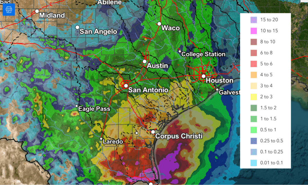
According to LCRA’s Hydromet, the lowest totals of rain over the past couple of days occurred across the northern and western Hill Country, generally west of a line stretching from Junction to San Saba. Totals through 9 am Friday across this area averaged less than a quarter inch. Across the remainder of the Hill Country and Central Texas, most totals averaged between 0.5 and 1 inch, with a few isolated heavier totals. Across the middle Texas coast, amounts generally averaged between 1 and 2.5 inches. The Bay City area in Matagorda County, appears to have received the most rain through 9 am Friday, with a total of 3.22 inches.
While additional rain is forecast Friday afternoon, the threat for heavy, flooding rain has diminished. Because of this, the National Weather Service has canceled the Flood Watch which had been posted for the middle Texas coast and parts of Central Texas. Widespread light to moderate rain and isolated thunderstorms are forecast from the eastern Hill Country, southeast to the Texas coast Friday afternoon as a trough of low pressure slowly moves east out of Central Texas.
- The probability for rain will range from 40 percent across the eastern Hill Country, to 70 percent across Central Texas, to 90 percent across the coastal region
- The chance for rain looks to diminish from west to east late Friday afternoon into Friday evening
- Additional rain amounts through Friday evening are forecast to average around a quarter inch or less across Central Texas, and between 0.5 and 1 inch across the coastal plains
A cloudy sky is forecast Friday night into Saturday morning. Clouds will decrease and the sky will become mostly sunny Saturday afternoon. A similar pattern of morning clouds and afternoon sunshine is forecast for Sunday. With the sunshine, the temperature is expected to be a bit warmer over the weekend.
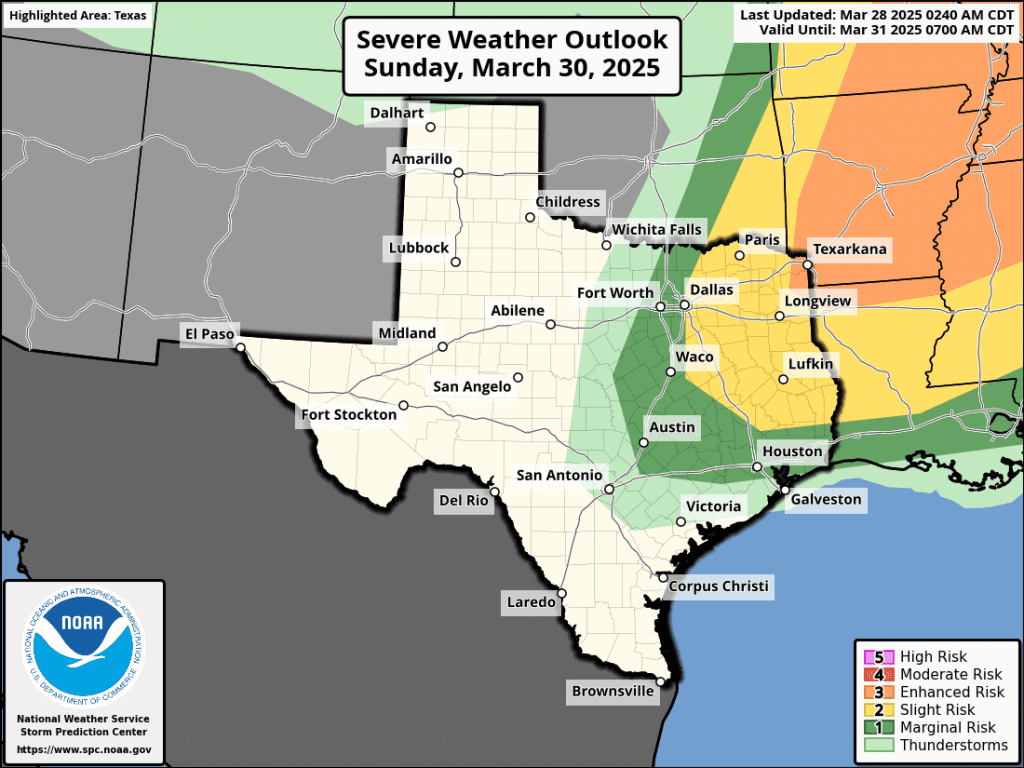
A trough of low pressure pushing northeast out of the southern Rockies on Sunday will help to push a cold front south through the Hill Country, Central Texas, and coastal region Sunday afternoon into Sunday night. While large-scale lift associated with trough is expected to remain north of our area, atmospheric conditions ahead of and along the cold front may support the development of a few widely scattered thunderstorms—mainly across the northeastern Hill Country and the northern half of Central Texas. The probability for rain will be 20 percent. Some of these storms could possibly become strong to severe. The Strom Prediction Center has placed these two areas under a Marginal Risk, or 1 out of 5 risk, for severe thunderstorms Sunday afternoon into Sunday night. The primary severe weather risks will likely be large hail and damaging winds.
- High temperatures Friday will generally be in the mid 70s
- Highs Saturday are forecast to be in the low and mid-80s
- High temperatures Sunday will generally be in the mid-80s, with upper 80s across the Hill Country
- Low temperatures Saturday and Sunday mornings are forecast to be in the low and mid-60s
- Lows Monday morning will range from the mid-50s across the Hill Country, to the mid and upper 60s near the coast
The first half of next week is shaping up to be mostly sunny and warm. Sunday’s cold front is predicted to move back to the north late Monday, allowing for a return of southerly winds and warmer temperatures.
- High temperatures are forecast to be in the upper 70s Monday, warming to the low and mid-80s Tuesday
- High temperatures Wednesday are predicted to be near 90-92 degrees, with upper 80s near the coast
- Lows will generally be in the upper 50s to mid-60s
The outlook for Thursday through next weekend, calls for more sunny and warm weather. However, there will be a slight chance for scattered afternoon and evening thunderstorms each day across the Hill Country and Central Texas regions as a series of weak troughs track move across the southern Plains. Significant or heavy rain is not expected. Forecasts point to a somewhat better chance for rain for the entire region around Monday, April 7th and 8th. No significant change in the temperature is forecast over the next ten days.
Have a good weekend!
Bob
Social Media