Thursday’s severe weather threat never quite came together across Central Texas or the middle Texas coast. However, showers and thunderstorms across the coastal plains did bring totals of 1-1.5 inches of rain to Matagorda and southern Wharton Counties. Totals were considerably lower across the rest of the region, with little to no rain falling across the Hill Country.
Overnight, a weak cold front dropped south through the region, bringing drier air and shifting winds out of the north. As of midday Friday, the front was situated along the middle Texas coast, near Bay City. The front is forecast to push just off the coast and stall Friday afternoon. While the sky has cleared across the Hill Country and the Interstate 35 corridor, satellite images show a large area of clouds blanketing South and Southeast Texas, generally south of a line stretching from Laredo, to La Grange, to Lufkin. The clouds are predicted to remain over this same general area Friday afternoon through Friday night. In addition, an atmospheric disturbance moving northeast along the coast will cause a 30 percent chance for rain showers for areas south of Interstate 10 through Friday evening. Rain amounts will be low—averaging less than a quarter inch. The chance for rain looks to diminish Friday night. For the Hill Country and the Austin/Interstate 35 corridor, expect a mostly sunny sky Friday afternoon.
Dry weather, a mostly sunny sky, and fall-like temperatures are forecast across the entire region this weekend as the storm track moves back to the north. Another weak cold front is predicted to spread across the area Saturday night into Sunday morning, bringing just slightly cooler air. No rain or clouds are expected with the front.
- High temperatures Friday will be in the upper 60s to low 70s.
- Lows Saturday morning are forecast to be in the mid and upper 40s across the Hill Country and Central Texas regions, and in the mid and upper 50s across the coastal region.
- High temperatures Saturday and Sunday will generally be in the low 70s.
- Lows Sunday morning will range from the upper 30s across the Hill Country, to the upper 40s across the coastal plains.
- Low temperatures Monday morning will range from the low 40s across the Hill Country, to the upper 40s near the coast.
The outlook for next week calls for continued mostly sunny and dry weather as a broad ridge of high pressure sets up across Texas and the Southwestern U.S. The week will feature mild afternoons and cool nights. Expect high temperatures to be in the upper 60s to low 70s, with low temperatures in the mid and upper 40s.
Longer-range forecasts are pointing toward a chance for rain taking shape next weekend as the ridge over Texas weakens and a southwesterly flow begins to develop out to the eastern Pacific. This chance for rain looks to extend into the first half of the following week as a large trough of low pressure pushes east out of southern California.
Temperatures are forecast to trend a little cooler beginning Sunday, December 10th, when a Canadian cold front pushes south through the area. High temperatures behind the front are forecast to fall to the 50s, with lows generally in the low and mid-40s.
Long-range forecasts are still not showing any arctic air headed our direction over the next two week period.
Tropical Weather Outlook
The 2023 Atlantic hurricane season came to an end Thursday. Weather conditions are currently quiet across the tropical Atlantic and are expected to stay that way for the next few months as water temperatures cool and atmospheric conditions become very unfavorable for tropical development.
The 2023 hurricane season turned out to be the 4th most active hurricane season on record. There were 20 named storms, with 7 of those storms becoming hurricanes. 3 major hurricanes occurred during the season.
November Weather was Cooler and Drier than Normal
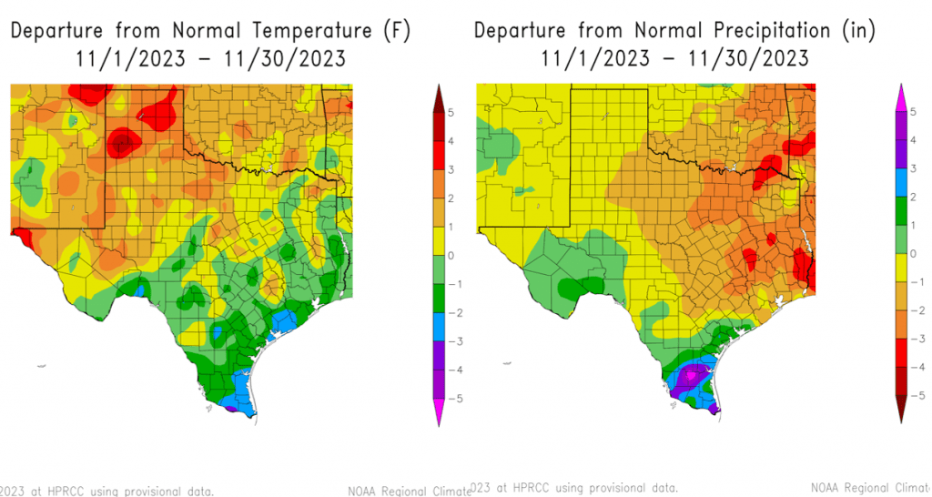
Thanks to numerous cloudy days and fall cold front, November’s temperature averaged between 0 and 2 degrees below normal across the Hill Country, Central Texas, and South Texas. November was the first month since April with the temperature averaging below normal.
November rainfall was below normal across the most of the region. Data shows the rain averaged about an inch below normal across the western half of the Hill Country and between 1 and 2 inches below normal across the eastern half. Across Central Texas, including Colorado County, rainfall averaged between 1 and 2 inches below normal. Wharton and Matagorda Counties saw near normal rainfall during November, with widespread totals of 3-5 inches.
- Austin, Camp Mabry recorded a November average temperature of 59.5 degrees, which was 1.5 degrees below normal. Rainfall totaled 1.21 inches, which was 1.71 inches below normal.
- Austin-Bergstrom Airport recorded a November average temperature of 58.9 degrees, which was 0.4 degrees below normal. Rainfall totaled 1.36 inches, which was 1.32 inches below normal.
Have a great weekend!
Bob
Social Media