No change to the current dry and warm weather pattern is expected this week across Texas. Forecasts call for the storm track to remain to the north of the state continuing into next week. At the same, only limited amounts of moisture will be able to spread north from the Gulf. This will result in continued sunny, dry, and breezy weather conditions stretching into next week. Unfortunately, elevated to critical fire weather conditions will continue—especially for areas located along and to the west of Interstate 35.
Monday through Wednesday
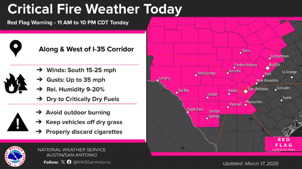
Developing low pressure across the southern Rockies Monday is creating a strengthening pressure gradient across the state. This will result in the development of breezy southerly winds of 10-20 mph, with gusts to near 30 mph Monday afternoon and Monday night. Despite winds being off the Gulf, very dry air is predicted to continue into Monday evening. Minimum relative humidity values are forecast to fall below 20 percent across the Hill Country and the Interstate 35 corridor Monday afternoon into Monday evening. This combination of gusty winds, very dry air, and critically to extremely dry fuels will create Critical Fire Weather conditions for areas along and west of Interstate 35. The National Weather Service has posted a Red Flag Warning for this general area through 10 pm Monday evening.
- High temperatures Monday are forecast to be in the low and mid-80s
- Lows Tuesday morning will be in the low and mid-50s
- High temperatures Tuesday are predicted to be in the mid-80s
- Lows Wednesday morning will be in the mid and upper 50s, with upper 60s expected towards the coast
- Highs Wednesday will range from the low 70s across the Hill Country, to the low 80s near the coast
Even stronger winds are forecast across the area Tuesday as the pressure gradient strengthens ahead of a storm system pushing east out of the southern Rockies. Gusts to near 40 mph are predicted for most of the region Tuesday afternoon into Tuesday evening. Relative humidity readings are forecast to be slightly higher—in the range of 15-25 percent. The strong wind and dry air will likely create more critical fire weather conditions for areas along and to the west of Interstate 35. The NWS indicates they may post another Red Flag Warning for this area on Tuesday.
Forecasts call for a cold to sweep southeast across the region late Tuesday night into Wednesday morning. No rain is expected with the front as most of the atmospheric dynamics will remain well north of our region. The front will bring drier and slightly cooler air. In addition, strong northerly winds with speeds of 15-25 mph and gusts to 30 mph can be expected Wednesday afternoon and evening. The combination of the strong winds and dry air will likely cause elevated to critical fire weather conditions in place across the entire region on Wednesday.
Wednesday through Saturday
Cooler air will spread across the area Wednesday night through Thursday. Milder air will begin returning Friday into Saturday. Lighter winds are forecast Thursday, which should help ease the fire threat temporarily. However, wind speeds are forecast to increase Friday and through the weekend. Elevated to critical fire weather conditions are forecast.
- Lows Thursday morning will include the upper 30s across the Hill Country, the low 40s across Central Texas, and the mid to upper 40s across the coastal plains
- High temperatures Thursday are forecast to be in the low 70s
- Lows Friday morning will be in the mid and upper 40s
- Highs Friday are forecast to be near 78-80 degrees
- Lows Saturday morning will be in the mid 50s
- High temperatures Saturday are forecast to be mid-80s
Sunday and Next Week
Forecasts call for a cold front to push southeast across the area Sunday afternoon into Sunday night. Unlike the past few fronts, a bit more moisture is forecast to return ahead of the front. This will result in a slight chance for a few rain showers and isolated thunderstorms along the cold front when it moves across the eastern Hill Country, Central Texas, and coastal regions. Rain amounts, are predicted to only be around a tenth of an inch.
Dry weather is forecast next Monday and Tuesday. Expect highs in the 80s, with lows in the 50s.
Another chance for rain is showing up for the middle of next week when a trough of low pressure moves over the area. Rain amounts are forecast to again only be around a tenth of an inch. Highs mid and late week are forecast to be in the 80s, with lows in the 50s and 60s.
First Day of Astronomical Spring
Astronomical spring, or the Vernal Equinox, begins on Thursday, March 20, 2025 at 4:01am CST. Near equal amounts of daylight and darkness will result.
Bob
Social Media