It’s early October and so far, autumn-like weather has been a no show. While nighttime temperatures have been fairly pleasant lately, daytime temperatures have been similar to what we typically see in late August. Unfortunately, this prolonged summer-like pattern doesn’t show signs of going away anytime soon. While readings are expected to trend a little cooler/less hot next week, it looks like it’s going to be a while yet before we see that first strong cold front of fall and some rain.
Dry and quiet weather continues across the region as we close out the workweek. However, one subtle change in the pattern is noted across the western Gulf of Mexico where a weak trough of low pressure is helping to pull an area of enhanced moisture toward the Texas coast. Doppler radar at midday showed an area of scattered rain showers and thunderstorms located just off the Texas coast, with the activity slowly moving to the west. This area of moisture is forecast to slowly spread inland this afternoon and Saturday and is expected to bring a slight chance for scattered rain showers and isolated thunderstorms to the coastal plains region—mainly over the area located to the south of Interstate 10. The chance for rain will only be 20 percent, and rain amounts are forecast to total less than a quarter inch. The chance for spotty rain will diminish Sunday as the area of moisture shifts to the south.
For the Central Texas and Hill Country regions, no rain is forecast this afternoon or Saturday as the atmosphere remains too stable. Expect a sunny to mostly sunny sky. Conditions will likely feel a bit more humid Friday afternoon through Sunday as the area of moisture spreads further inland. Little change in the temperature is forecast through Sunday.
- High temperatures Friday through Sunday are forecast to be in the low to mid 90 across the Hill Country and coastal regions, and in the mid-90s across Central Texas
- Low temperatures Saturday through Monday mornings will range from the low and mid-60s across the Hill Country, to the low 70s across the coastal plains
For next week, no significant changes are forecast as Texas will continue to remain under the influence of a broad, stable area of high pressure covering the Southwestern U.S. and northern Mexico. Forecasts do call for a weak cold front to push southwest across the region Monday. With little moisture in place, no rain is expected with the front. Dry and just slightly cooler conditions look to follow the cold front beginning late Monday, continuing through next Friday. Nighttime temperatures do look to be a touch cooler.
- High temperatures next Tuesday through Friday are forecast to be around 90 degrees across the Hill Country and in the low 90s across Central Texas and the coastal plains
- Low temperatures next Tuesday through Saturday mornings are forecast to be in the upper 50s across the Hill Country, in the upper 50s to low 60s across Central Texas, and in the low 60s across the coastal plains
Looking out a little further, Friday’s long-range forecast solutions show no significant changes in the weather for our region through the week of October 14th. The large ridge of high pressure over the Southwestern U.S is forecast to finally weaken, but the solutions still show no systems that would bring decent rain or noticeably cooler temperatures to our region. High temperatures are predicted to be near 88-90 degrees, with lows in the low 60s.
Tropical Weather Update
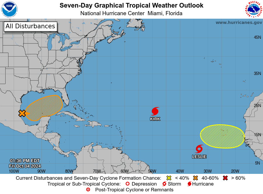
National Hurricane Center forecasters are continuing to keep a close watch on the western Gulf of Mexico where a trough of low pressure is producing widespread shower and thunderstorm activity. A broad area of low pressure is expected to develop over the southwestern or south-central Gulf of Mexico from this system during the next day or two, and additional subsequent development is possible while the low moves slowly eastward or northeastward. NHC indicates a tropical or subtropical depression or storm could form during the early to middle part of next week if the low remains separate from a frontal boundary that is forecast to sink into the Gulf of Mexico. This system is forecast to move to the east-northeast ahead of the cold front and will pose little threat to the Texas coast. Regardless of tropical or subtropical development, the system is forecast to bring locally heavy rain to portions of Mexico and the Florida Peninsula late this weekend into next week.
NHC forecasters are giving this system a 50 percent chance for tropical development over the next seven days.

Elsewhere, the National Hurricane Center is currently monitoring Major Hurricane Kirk located over the central tropical Atlantic, and Tropical Storm Leslie, located over the eastern tropical Atlantic.
Kirk is packing winds of 140 mph and is moving to the northwest. Kirk is forecast to slowly weaken over the weekend as it turns to the north over the open Atlantic. Leslie has maximum winds of 65 mph and is moving to the west-northwest. Leslie is forecast to strengthen and become a hurricane over the weekend as it moves to the northwest into the open Atlantic. Leslie is posing no threat of moving into the Gulf of Mexico.
In the far eastern Atlantic, a tropical wave is expected to move westward from the coast of Africa on Monday or Tuesday. Some development of this system will be possible thereafter as it moves westward or west-northwestward across the eastern tropical Atlantic. NHC forecasters are giving this system a 20 percent chance for tropical development over the next seven days.
Have a great weekend!
Bob


Social Media