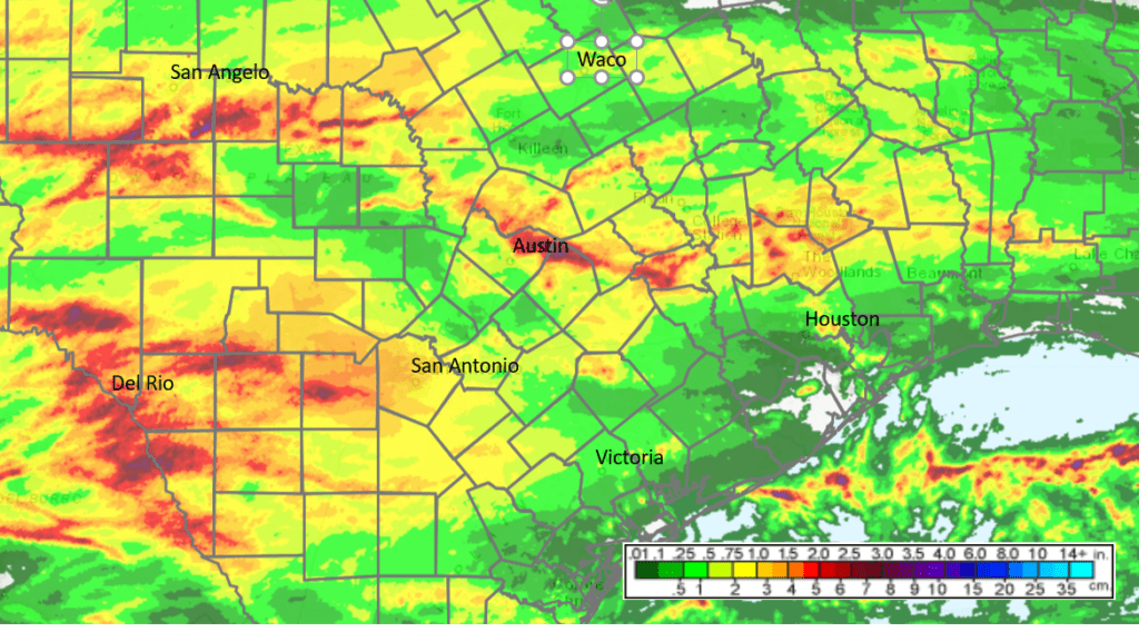
Widespread rain developed across the Hill Country and Central Texas regions Sunday night into Monday morning as a cold front and wave of low pressure moved across our region. The highest totals of rain occurred along a corridor stretching from San Angelo to San Saba, then southeast to Round Rock and North Austin, and southeast to Lexington and Brenham. Within this corridor, most totals were in the generally in the range of 1.5-2.5 inches. To the south of this corridor, most totals were less than 0.75 inches. The rains weakened considerably as they spread into the coastal counties, where totals have been just a couple hundredths of an inch. The highest gauged 24-hour total on LCRA’s Hydromet was 2.70 inches, recorded at a US Geological Survey gauge located in northeast Travis County, between Pflugerville and Manor.
NWS Estimate of Rain Falling between 2 pm Sunday and 2 pm Monday:
Early Monday afternoon, Doppler radar showed a an area of scattered light rain showers spreading east across the coastal plains region. Another area of mainly light rain was located across parts of the Hill Country. High-resolution forecasts call for occasional light rains to continue over parts of the Hill Country and the coastal plains region through late afternoon. Rain amounts are forecast to average less than a tenth of an inch. The rain is predicted to diminish by early evening. Elsewhere, expect an overcast sky and generally dry weather. Afternoon temperatures will be noticeably cooler—ranging from the mid and upper 60s across the Hill Country, to the low 70s across the coastal plains.
An overcast to mostly cloudy sky is forecast across the region Monday night. The clouds are forecast to decrease from northwest to southeast late Monday night into early Tuesday morning. Lows Tuesday morning will include the upper 40s across the Hill Country, the low 50s across Central Texas, and the mid to upper 50s across the coastal plains region.
Sunny and dry weather is forecast across the region Tuesday through Friday as Texas comes under the influence of a stable ridge of high pressure. A second push of cool air is predicted to spread south through our region Monday night into Tuesday morning, bringing even cooler temperatures for Tuesday and Wednesday. In fact, Tuesday night is shaping up to be the chilliest night of the week. But the batch of cool isn’t expected to stick around for long as southerly breezes return late week, along with milder temperatures.
- Lows Wednesday morning are forecast to be in the mid and upper 30s across the Hill Country. Do note, a few low spots could see readings bottom out around freezing. Lows across Central Texas are forecast to be near 38-42 degrees, with lower 40s expected across the coastal plains.
- Lows Thursday morning will generally be in the mid and upper 40s.
- Lows Friday morning will range from the upper 40s across the Hill Country, to the mid-50s across the coastal plains.
- High temperatures Tuesday are forecast to be in the upper 60s.
- High temperatures Wednesday are forecast to be in the low 70s.
- High temperatures Thursday and Friday are forecast to be in the low and mid-80s.
The outlook for the upcoming weekend calls for a mostly sunny sky. Expect high temperatures in the mid and upper 80s, with low temperatures generally in the mid-60s.
The outlook for next week calls for a slight chance to a chance for rain to develop across Central and South Texas Monday and Tuesday when trough of low pressure tracks across northern Texas out of the southern Rockies. The best chance for rain is expected to occur over areas along and to the east of Interstate 35. As of now, rain amounts are forecast to average less than a quarter inch for locations west of I-35, and be between a quarter and a half inch for locations east of I-35. Mostly sunny and dry weather is forecast next Wednesday through Friday.
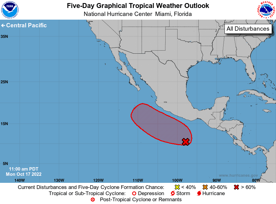
One item to keep an eye this week will be potential tropical development in the eastern tropical Pacific Ocean. National Hurricane Center forecasters indicate an area of low pressure is expected to form in a day or two a few hundred miles south of the southern coast of Mexico. Environmental conditions are forecast to be conducive for development, and a tropical depression is likely to form late in the week while the system moves westward to west-northwestward at 10-15 mph. Some of today’s forecasts indicate the trough moving out of the southern Rockies early next week could possibly pull the depression north to the northwestern coast of Mexico early next week, with some of the system’s middle and high-level moisture getting pulled north into Texas. Should this be the case, higher rain amounts will be possible the first half of next week.
Temperatures next week are forecast to mild, with highs mostly in the mid-80s, and lows in the mid-60s.
Tropical Weather Outlook
Weather conditions are quiet across the tropical Atlantic, the Caribbean Sea and the Gulf of Mexico. Tropical cyclone development is not expected for at least the next 5 days.
Have a good week.
Bob
Social Media