Here’s an update on this week’s cold weather pattern and the potential for wintery weather.
Arctic high pressure spread south into Texas behind a cold front late Sunday, bringing some of the coldest air since last January. Low temperatures Monday morning were generally in the low and mid-20s across the Hill Country, in the upper 20s across Central Texas, and in the upper 20s to low 30s across the coastal plains. Winds have been gusting up to 25/30 mph since Sunday afternoon and similar gusty conditions are expected to continue through late Monday afternoon. Wind speeds are forecast to diminish to 5-10 mph Monday night.
A sunny to mostly sky is forecast across the region Monday afternoon through Tuesday. Forecast solutions continue to call for a trough of low pressure over northern Mexico to track northeast across Texas late Wednesday through Friday morning that will have the potential to bring precipitation and winter weather to much of West, North, and Central Texas (more on that below). Temperatures are predicted to stay cold throughout the week, with slightly milder readings expected Friday through the upcoming weekend.
Updated temperature forecasts show few changes from what has been forecast over the past couple of days:
- Lows Tuesday morning are forecast to be in the low and mid-20s across the Hill Country, in the mid and upper 20s across Central Texas, and the upper 20s across the coastal plains
- Lows Wednesday morning are predicted to be in the mid-20s across the Hill Country, the upper 20s across Central Texas, and in the low to mid-30s across the coastal plains
- Lows Thursday morning are forecast to be in the mid and upper 20s across the Hill Country, around 30 degrees across Central Texas, and in the mid-30s across the coastal region
- Lows Friday morning are forecast to be in the upper 20s across the Hill Country, the low 30s across Central Texas, and in the mid-30s towards the coast
- Lows Saturday morning will include the upper 20s across the Hill Country and Central Texas regions, and in the low to mid-30s across the coastal plains
- High temperatures Monday and Tuesday will generally be in the mid-40s
- High temperatures Wednesday are forecast to be in the upper 30s
- Highs Thursday are predicted to be in the mid-30s across the Hill Country, the upper 30s across Central Texas, and the low 40s coastal plains
- High temperatures Friday will range from the low 40s west, to the upper 40s near the coast
- Highs on Saturday are forecast to be in the low and mid 50s
The outlook for mid and late week continues to be somewhat uncertainty. However, confidence is increasing for a potentially impactful winter storm to affect much of West and North Texas, and possibly into parts of Central Texas. The upper trough lifting northeast out of Mexico late Wednesday into Thursday is expected to pull warm Gulf air up and over the very cold air at the surface, creating favorable conditions for the development of precipitation across much of the state. As mentioned yesterday, the biggest problem yet to be worked out is how far the warmer air will spread inland, delineating the areas that will see wintery weather and which areas will just see rain. The consensus of the latest forecast solutions continues to show that zone setting up somewhere near the Balcones Escarpment/Interstate 35 corridor sometime late Wednesday into Thursday morning. There are indications the western Hill Country/Edwards Plateau could see at least 1 inch of snow accumulation from this event.
Based on these solutions, a mix of sleet showers and snow showers is forecast to develop across the Hill Country and Edwards Plateau regions after midnight Wednesday night. A mixture of sleet showers, snow showers and rain showers is forecast for the Austin and Interstate 35 corridor after midnight. For areas east of Interstate 35, there will be a chance for rain showers developing late Wednesday night.
For Thursday, a mix of freezing rain, rain showers, and snow showers is forecast across the Hill Country Thursday morning. Much of the precipitation should transition to just rain showers Thursday afternoon as the temperature rises above freezing. For the Austin and I-35 corridor, a mix sleet showers and rain showers is forecast early Thursday morning, with the precipitation becoming all rain late Thursday morning through Thursday afternoon. A good chance for rain is forecast across the coastal plains.
For Thursday night, a mixture of freezing rain, sleet showers and snow showers is forecast across the Hill Country as temperatures fall back below freezing. For the Austin/I-35 corridor and areas east, a good chance for rain showers looks to continue Thursday night as the temperature holds just above freezing.
The chance for precipitation is forecast to end from west to east late Thursday night into Friday morning as the upper trough exits to the northeast. Forecasts do call for another cold front to push south across the area on Saturday that will reinforce the cool conditions already in place. No rain is forecast along the cold front.
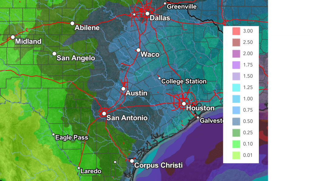
I do want to mention that in addition to the threat for wintery weather, the trough late week looks to being some very beneficial rain to much of the area. Rainfall forecasts through Saturday afternoon call for totals of 0.25 to 0.75 inches across the Hill Country, between 0.5 and 1.25 inches across Central Texas and the middle Texas coast.
NWS Rainfall Forecast for the Period 6 pm Monday through 6 pm Saturday:

Bob


Social Media