Weather Highlights
- Sunny and dry weather will be in place throughout the week
- An approaching storm system will cause gusty winds to increase across the region Tuesday through Wednesday
- A second system is expected to cause another period of strong and gusty winds Friday into Saturday
- Elevated to critical fire weather conditions will develop due to the strong winds, dry air, and dead vegetation.
- Long-range forecasts call for little to no rain across the area next week
Discussion
Saturday’s cold front brought a blast of colder air that lingered into Monday morning. In fact, a light freeze occurred across a large part of the Hill Country early Monday. According to LCRA’s Hydromet, low temperatures Monday morning included the upper 20s to mid-30s across the Hill Country, the mid and upper 30s across Central Texas, the mid and upper 30s across Central Texas, and the upper 30s to mid-40s across the coastal plains region.
We’re looking at another week of spring-like weather across the region, featuring more periods of strong wind and elevated fire risks. Unfortunately, no rain is forecast through the upcoming weekend as the atmosphere over Texas looks to remain too dry and stable.
The weather will be sunny and quiet Monday through Tuesday. At the surface, a large dome of Canadian high pressure will be shifting off to the east Monday afternoon and Monday night, causing the return of west and southwesterly winds. Speeds of 5-10 mph are forecast Monday afternoon and Monday night. Wind speeds are predicted to increase to a range of 10-15 mph, with gusts to near 25 mph Tuesday through Tuesday night. With the return of southwesterly breezes, warmer temperatures are forecast.
- High temperatures Monday are forecast to be in the upper 70s
- Lows Tuesday morning will generally be in the mid-40s
- High temperatures Tuesday are forecast to be near 80-82 degrees
- Lows Wednesday morning will range from the low 50s across the Hill Country, to the upper 50s across the coastal plains
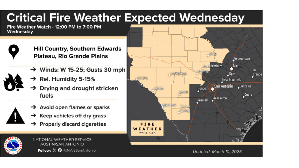
Mostly sunny and breezy weather is forecast Wednesday. Our weather will be influenced by a fast-moving trough of low pressure that will be lifting northeast our or northern Mexico. A lack of moisture ahead of this system will likely preclude the development of any rain or storms as the trough moves across Northwest Texas. However, a strong pressure gradient around the trough is expected to cause gusty southwesterly winds at speeds of 10-20 mph, with occasional gusts to 30 mph. Wind speeds will stay strong into Wednesday night, then decrease to around 5-10 mph on Thursday. Sunny and less breezy weather is forecast Thursday in the wake of the departing upper tough.
- High temperatures Wednesday are forecast to be in the mid-80s
- Lows Thursday morning will be in the mid and upper 50s
- High temperatures Thursday are predicted to be in the upper 80s
- Lows Friday morning will be in the low 60s
Warm and windy weather is forecast to develop across the region Friday as yet another Pacific trough of low pressure tacks from southern California to the southern Plains states. With this system, the surface and upper level low pressure systems are forecast to be nearly on top of each other, and the stacked low pressure system is expected to generate a large-scale swath of intense surface winds stretching from southern Texas northeastward through the Plains and into the Midwest. Friday winds are forecast to be in the range of 15-25 mph, with gusts to near 40-45 mph. Wind speeds are predicted to decrease Friday night into Saturday as a Pacific cold moves east across the state.
- High temperatures Friday are forecast to be around 90 degrees
- Lows Saturday morning are will range from the low 50s across the Hill Country, to near 60 degrees towards the coast
Sunny, dry, and mild weather will continue for the upcoming weekend as a weak ridge of high pressure builds over the state. High temperatures Saturday will be in the mid-70s, warming to the low 80s on Sunday. Lows look to be in the upper 40s to low 50s.
Looking ahead to next week, more sunny and mild weather is forecast. A trough lifting northeast to the Plains states Tuesday night into Wednesday will likely cause another period of strong winds the middle of the week. A few spotty light rain showers may accompany a Pacific cold front on Wednesday. However, rain amounts of only a few hundredths of an inch are forecast.
No big changes in the temperature are forecast. Highs next Monday through Wednesday are predicted to be in the mid and upper 80s. Lows will be in the upper 50s to the mid-60s. Slightly cooler temperatures are forecast for next Thursday and Friday.
Fire Weather Concerns
Increasing winds and low relative humidity readings will combine to produce elevated to near-critical fire weather conditions across the Hill Country and Central Texas regions Tuesday and again on Wednesday.
The fire threat should lower somewhat on Thursday.
Critical fire weather conditions are forecast to be in place across the Hill Country and Central Texas region Friday into Saturday due to very strong winds and low relative humidity levels develop ahead of and behind a Pacific cold front.
Residents are urged to exercise care with respect to all outdoor activities that could inadvertently cause wildfires.
Total Eclipse of the Moon Thursday Night
There will be a total lunar eclipse of the full “earthworm” full moon visible across all of North America Thursday night into Friday morning. In a lunar eclipse, the Earth’s shadow will move across the moon, causing the moon to go nearly dark. However, light flowing through edge of Earth’s atmosphere is expected to cause a reddish color to the moon.
Total eclipse begins at 1:26 am CDT, mid-eclipse will be at 1:59 am CDT, with the total eclipse ending at 2:32 am CDT.
No special glasses or equipment will be needed to see this spectacular event!
Bob
Social Media