Freezing temperatures were reported across much of the region early Friday. Lows Friday morning included the mid and upper 20s across the Hill Country, the upper 20s to low 30s across Central Texas, and mid to upper 30s across the coastal plains. According to LCRA’s Hydromet, the lowest gauged temperature was 20 degrees, at a location about 5 miles south of the town of Telegraph, in northern Edwards County. In Austin, Camp Mabry recorded a low temperature of 33 degrees and Austin-Bergstrom saw 27 degrees.
Quiet weather is in place as we close out the work week. However, numerous change in the weather are expected to take place as we move through the weekend and next week.
Friday morning’s satellite images showed considerable mid-level clouds spreading over the region out of northeastern Mexico. These clouds will result in a partly to mostly cloudy sky Friday afternoon. Expect high temperatures to generally be in the upper 50s to low 60s.
Widespread lows clouds are forecast to develop across the area by midnight Friday night as a weak overrunning pattern begins to develop. Patchy drizzle and even a few spotty light rain showers are predicted to develop beginning late Friday night and continuing through Saturday afternoon as a weak trough of low pressure passes over the area. The chance for rain is expected to diminish late Saturday afternoon through Saturday evening. Rain mounts are forecast to be less than a tenth of an inch, with isolated amounts up to a quarter inch. Temperatures will trend warmer Friday night through Saturday night.
- Lows Saturday morning will range from the low and mid-40s across the Hill Country, to the low 50s near the coast.
- High temperatures Saturday are forecast to be in the mid-60s. Low 70s are forecast for the coastal area.
- Low temperatures Sunday morning are forecast to be in the mid and upper 50s.
A chance for rain showers will return to the forecast after midnight Saturday night when another trough of low pressure begins to move toward Texas out of northern Mexico. There will be a 40-50 percent chance for rain showers and scattered thunderstorms across the region Sunday morning into Sunday afternoon as the trough moves over the area. The chance for rain will be enhanced by a Canadian cold front that will be pushing southeast across the area. Some of the thunderstorms may be strong to severe—especially for areas along and south of Interstate 10. The Storm Prediction Center has placed Colorado, Wharton, and Matagorda Counties under a Marginal Risk (a 1 out of 5 risk) for severe thunderstorms Sunday. Large hail and damaging downburst winds will be possible with any potentially severe storms. The front it forecast to exit Central Texas by mid-afternoon Sunday and move off the coast sunset. The chance for rain is expected to diminish behind the cold front as cooler as drier air spreads south. Rain amounts Saturday night through Sunday evening are forecast to total less than a quarter inch across the Hill Country, and be between 0.25 and 0.5 inches across Central Texas. Significantly higher totals are forecast across the coastal plains, where amounts are forecast to average closer to an inch. Ahead of the cold front, temperatures are forecast to warm into the 60s. Readings are forecast to fall through the 50s Sunday afternoon as the front moves south to the coast.
Partly cloudy and cooler weather will be in place Sunday night. Lows Monday morning will range from the upper 30s to low 40s across the Hill Country, to the low 50s across the coastal plains.
A period of cloudy, wet, and cool weather is predicted to set up across our area beginning Monday morning as a large trough of low pressure stalls over the southwestern U.S. between Monday and Thursday. The cold temperatures will be reinforced by a second Canadian cold front pushing south across the area Monday. The trough is expected to pull warm, moist air up and over the cool air at the surface, resulting in widespread overrunning clouds and periods of rain. The probability for rain each day is expected to be near 50-60 percent. Mostly light to moderate rain is predicted for Monday and Tuesday, with daily totals in the range of 0.25 to 0.5 inches. A more moderate rain rate is forecast for Wednesday and Thursday when the upper trough finally moves across northern Texas and the southern Plains. Totals of 0.5 to 1 inch can be expected.
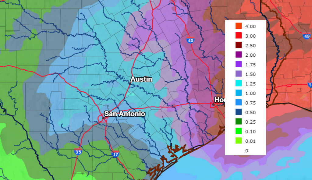
Total rainfall through next Friday morning is forecast to generally average between 0.5 and 1.5 inches across the Hill Country and Central Texas regions, and between 1.5 and 2 inches across the coastal plains.
NWS Rainfall Forecast for the Period 6 pm Friday through 6 pm next Friday:
As of now, it appears all of next week’s precipitation will fall as liquid across the Hill Country, Central Texas and coastal regions. But if temperatures happen to trend a little colder, some light freezing rain or freezing drizzle will be a possibility for the northern and western Hill Country.
- High temperatures Monday through Thursday are forecast to be in the mid-40s to 50 degrees across the Hill Country and Central Texas regions, and in the 50s to low 60s across the coastal plains.
- Lows Tuesday and Wednesday mornings are forecast to be in the low and mid-30s across the Hill Country, the upper 30s to 40 degrees across Central Texas, and in the mid-40s to low 50s across the coastal plains.
- Lows Thursday morning will range from the low 30s across the Hill Country, to the low and mid-40s across the coastal plains.
Sunny and dry weather is predicted for next Friday and next weekend. Expect high temperatures in the 50s to low 60s and low temperatures generally in the 30s.
Have a good weekend.
Bob
Social Media