Beryl Predicted to Impact Texas Weather by Monday
July 3, 2024
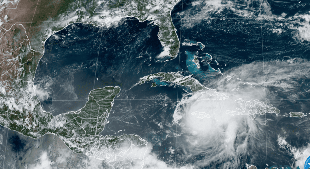
As of 4 pm Wednesday, the center of major hurricane Beryl was located across the central Caribbean Sea, roughly 65 miles southwest of Kingston, Jamaica.
While westerly wind has affected Beryl on Wednesday, the central core of the hurricane has made a bit of a comeback this afternoon with the eye becoming better defined in Cuban radar data and re-appearing in satellite imagery. Whether this has resulted in any re-intensification is unclear, so the initial intensity is still believed to be 140 mph. So far, the weakening process has been slower than expected. Beryl should continue to experience some westerly shear for the next 24 hours, and the ECMWF model forecasts moderate shear to persist until the hurricane makes landfall in Yucatan. Beryl is forecast to weaken to a tropical storm when it moves over the Yucatan Peninsula Friday. Wednesday’s intensity guidance has become less enthusiastic about the potential for Beryl to re-intensify once it is back over the Gulf of Mexico.
NHC’s intensity forecast now calls for the cyclone to regain category 1 hurricane strength on Sunday before the system makes landfall as a tropical storm somewhere along the western Gulf coast Sunday night.
Colorado State University/RAMMB/NOAA 07/03/24 2:40 pm CDT
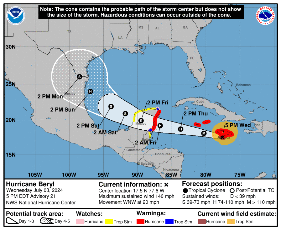
Forecast Track
A strong mid-level ridge of high pressure centered over the southeastern U.S. will continue steering Beryl generally west-northwestward but at a slower forward speed for the next couple of days or so. The motion should bring the center near or just south of Jamaica during the next 6 to 12 hours and to south of the Cayman Islands Wednesday night. After that, the system should reach the Yucatan Peninsula of Mexico early Friday, then emerge over the southwestern Gulf of Mexico Friday night.
A strong mid-level ridge centered over the southeastern US is expected to continue steering Beryl generally west-northwestward at a decreasing speed for the next couple of days or so. The motion should bring the center near or just south of Jamaica Wednesday evening, and south of the Cayman Islands Wednesday night. After that, the system should reach the Yucatan Peninsula of Mexico on Friday, and emerge over the southwestern Gulf of Mexico sometime late Friday night. Once over the Gulf, Beryl is forecast to northwestward toward a break in the subtropical ridge caused by a large mid-latitude trough over the central United
States. This forecast cycle, better agreement in the track guidance has taken place, as the GFS has shifted its track a little southward and the ECMWF has shifted its track a little northward. Based on this and other guidance, the National Hurricane Center official forecast track has shifted the Saturday and Sunday points a little to the southwest of the previous forecast. However, there is still uncertainty during this part of the forecast, and a landfall in Texas cannot yet be ruled out.
The official NHC forecast track is showing a potential landfall in northeastern Mexico, just to the south of the Rio Grande river, early Monday morning, with impacts starting along the lower Texas coast Sunday night. But do note the cone of uncertainty on the official track extends all the way north to Matagorda Bay.
Impacts:
It’s still too early yet to know any specific impacts from Beryl. However, increasing swells from Beryl are expected to reach the entire Texas coast by late Saturday and especially into Sunday. This will be ahead of tropical storm force winds arriving along the lower Texas coast Sunday. Increasing tides and squalls will be likely along the middle Texas coast Sunday into Monday
Based on the latest NHC forecast for Beryl to make landfall along the northeastern coast of Mexico late Sunday night, clouds, rain, and some wind associated with Beryl can be expected to spread north to the middle Texas coast beginning sometime Sunday afternoon/Sunday night. The clouds and rain are then forecast to spread northwest to cover Central Texas and much of the Hill Country next Monday through Wednesday.
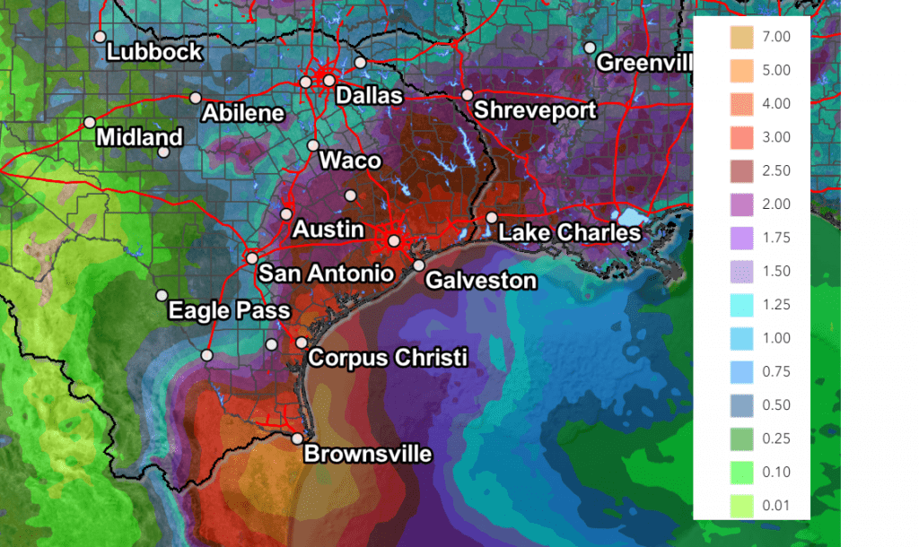
Cumulative totals through Tuesday evening could be as high as 2-4 inches across the coastal plains, and 1-2.5 inches across Central Texas, and around 0.5-1 inches across the Hill Country. As I pointed out Tuesday, please use WPC’s forecast as general guide. These forecasted totals will likely change over the coming days as the models get a better handle on where Beryl will make landfall and go from there.
Weather Prediction Center Rainfall Valid through Next Tuesday at 7 pm:
Stay tuned for further updates as the forecast path and potential impacts become clearer.
Bob
Social Media