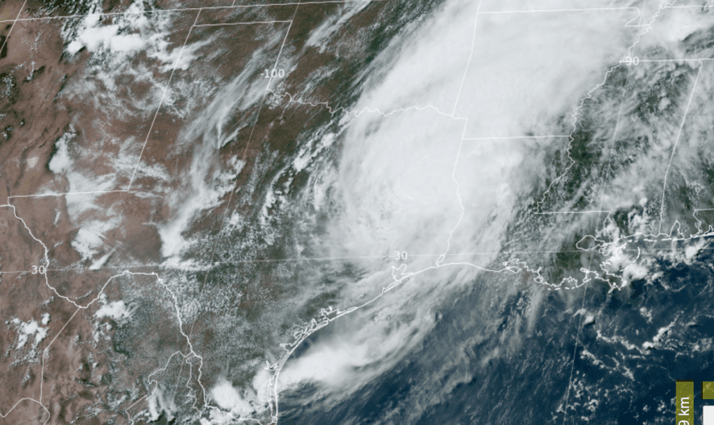
Hurricane Beryl moved inland around 4 am Monday morning near Matagorda with peak winds of 80 mph. The hurricane produced very strong winds and heavy rain across Colorado, Wharton, and Matagorda Counties overnight and into the morning hours. Wind gusts of 60-75 mph were reported across all three counties. A naval observing station at Matagorda City reported a sustained wind of 68 mph, with a gust to 86 mph just before landfall. LCRA’s Hydromet showed widespread totals of 5-6 inches occurring across Wharton and Matagorda Counties.
Once inland, the center of Beryl tracked to the north-northeast through the morning hours, passing just west of Houston. As of 1 pm, Beryl had been downgraded to a tropical storm and was centered about 55 miles north of Houston. A turn to the northeast, with an increase in forward speed is expected Monday night and Tuesday. On the forecast track, the center of Beryl will move over eastern Texas today, then move through the Lower Mississippi Valley into the Ohio Valley on Tuesday.
Maximum sustained winds have decreased to 60 mph, with some higher gusts. Steady weakening is forecast, and Beryl is expected to become a post-tropical cyclone on Tuesday.

NOAA/Colorado State University/RAMMB 07/08/24 3:00 pm CDT
As Beryl moves away from our region this afternoon, impacts from the storm will diminish. While some additional showers will be possible for the area east of Interstate 35, no heavy rain is expected. Wind speeds should slowly decrease.
Weather Outlook
Although Beryl been the weather headline for the past few days, another big weather headline has been the heat dome moving away from Texas. Late last week, the heat dome shifted from Texas to the West Coast, with another heat dome developing over the Southeastern U.S. Between the two heat domes, a broad trough of low pressure has developed from south central Canada to southern Texas. It’s this trough that allowed a weak cold front to sink south into Texas last Friday. Another cold front is currently situated over Northwest Texas. Forecasts call for the heat dome to remain out west through late week, and this will help to keep our high temperatures below 100 degrees. This weekend, the heat dome is predicted to shift back to the central and southern Rockies.
For Monday afternoon, there will be a 20 percent chance for scattered rain showers and thunderstorms across the region as the circulation around the backside of Beryl brings tropical moisture westward. Rain amounts, if any, should average well below a quarter inch.
For Tuesday through Thursday, a mostly sunny and dry weather pattern is forecast across the Hill Country and Central Texas regions. Daily high temperatures look to be in the mid-90s. For the coastal region, there will be 30-40 percent chance for scattered mainly afternoon showers and thunderstorms due to lingering tropical moisture and an active sea breeze. Rain amounts through Thursday are forecast to generally average around a half inch. Daily High temperatures are predicted to be around 90-92 degrees.
Friday through Sunday, there will be a 20-30 percent chance for scattered rain showers and isolated thunderstorms across the Central Texas and coastal regions due to an increase in tropical moisture spreading inland from the Gulf. Rain amounts are forecast to average less than a quarter inch. High temperatures should be in the mid and upper 90s across Central Texas, and the low 90s across the coastal areas. For the Hill Country, expect mostly sunny and dry weather with high temperatures in upper 90s.
The outlook for next week calls for more typical July-like weather, as the heat dome begins to spread east to cover Texas. Sunny and hot conditions are forecast, with daily high temperatures near 100 degrees across the Hill Country and Central Texas regions, and the mid upper 90s across the coastal plains
Following Beryl, weather conditions across the tropical Atlantic are quiet and additional tropical cyclone development is not expected for at least the next seven days.
Bob


Social Media