Weather Highlights
- Another hard freeze is forecast for the Hill Country and Central Texas regions Thursday night
- Friday’s weather will be cloudy and cold
- The eastern Hill Country and the Austin/Interstate 35 corridor will see a chance for some light freezing rain and freezing drizzle in the period after midnight Friday night through mid-morning Saturday
- Ice accumulations are forecast to forecast to average around 0.01 inch
- There will be an increasing chance for rain across the region Saturday afternoon through Saturday night. The rain should taper off from west to east Saturday night into early Sunday morning
- Sunny and milder weather is predicted for Sunday and next week
Discussion
The arctic air mass continues its grip across our region. Minimum temperatures Thursday morning ranged from the low and middle teens across the Hill Country, to the low and mid-20s across the coastal plains. Wind speeds are starting to decrease across the region as the center of the arctic air begins to settle south across Texas. Wind speeds are forecast to decrease to around 5-10 mph Thursday night and remain light Friday into Saturday.
Afternoon satellite image show a large area of low clouds spreading north over the Hill Country and Central Texas regions our of Deep South Texas. The clouds are associated with a weak overrunning pattern that is developing well out ahead of a trough of low pressure diving southeast out of the southern Rockies. This area of low clouds is forecast to cover the entire region by Thursday evening and remain over the area Friday and Saturday. The clouds are expected to clear from west to east Sunday afternoon as the upper trough exits to the northeast.
We still have another couple of cold nights and cold days to go before milder temperatures return. Here’s a recap of forecasted temperatures into the weekend:
- Low temperatures Friday morning will range from the low 20s across the Hill Country, to the mid-20s across Central Texas, to around 30-32 degrees across the coastal region
- High temperatures Friday are forecast to be in the mid and upper 30s across the Hill Country and Central Texas regions, and near 40 degrees towards the coast
- Lows Saturday morning will range from the upper 20s across the Hill Country, to the low and mid-30s across Central Texas, to the upper 30s across the coastal plains
- High temperatures Saturday are forecast to be in the low 40s across the Hill Country and Central Texas regions, and in the mid to upper 40s across the coastal plains.
- Lows Sunday morning will include the mid-30s across the Hill Country, the upper 30s across Central Texas, and the low 40s across the coastal plains.
- High temperatures Sunday are forecast to generally be in the low 60s.
The Potential for Freezing Rain/Freezing Drizzle
Thursday’s forecast solutions continue to show a low potential for the development of light freezing rain and light freezing drizzle across the eastern Hill Country and the Austin/Interstate 35 corridor from late Friday night through about mid-morning on Saturday. Clouds and moisture are predicted to spread northwest across the region Friday into Friday night ahead of the approaching through of low pressure. High resolution forecasts call for the development of some patchy drizzle and very spotty light rain from the coast into the eastern Hill Country after midnight Friday night, continuing into Saturday morning. With the temperature forecast to fall to or just below freezing over the Hill Country and the Austin/I-35 corridor Friday night, some of the precipitation could form a small amount of ice over this particular area. This will mainly be on exposed surfaces such as bridge and overpasses. General precipitation amounts through Saturday morning are only expected to total a couple hundredths of an inch. For areas east and southeast of Austin with warmer temperatures, the precipitation is expected to remain all liquid.
The chance for rain showers will increase across the eastern half of the Hill Country, Central Texas, and coastal plains beginning around midday Saturday, continuing through late Saturday night. The rain should exit the coastal region by mid-morning on Sunday. The probability for rain Saturday will be near 50-60 percent.
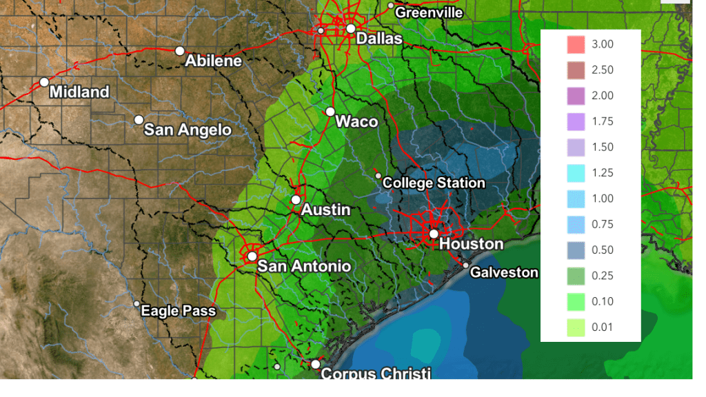
Rain amounts through Sunday are forecast to average between a quarter and a half inch from just east of Austin, southeast to the coast. Across the eastern Hill Country and the Austin/I-35 corridor, totals should average around a tenth of an inch or less.
NWS Rainfall Forecast Valid through 6 pm Sunday:
Next week’s weather continues to look dry and mild, with high temperatures in the mid and upper 70s. Lows should be in the 50s.
Bob
Social Media