Dry and summer-like weather continues across the area even though we are now moving into the second week of October. This situation is quite unusual as the month of October is typically one of the wettest and one of the most comfortable months of the year. Although the calendar shows we’re clearly in the season of fall, a summer-like dome of high pressure remains parked over the Southwestern U.S. and northern Mexico. The ridge is causing a summer-like weather pattern across Texas. This pattern looks to continue into next week, the finally begin to weaken.
This week’s weather is forecast to be sunny and continued dry as our region remains on the eastern periphery of that ridge of high pressure. A weak cold front currently located across North Texas, is forecast to sink slowly to the south and southwest across Central Texas and the middle Texas coast Tuesday into Wednesday. The front is expected to bring a push of drier air to the region mid and late week. This will result in little change in daily high temperatures and slightly cooler nighttime readings.
- High temperatures Monday afternoon through Friday afternoon are forecast to be in the upper 80s to 90 degrees across the Hill Country, and in the low to mid-90s across Central Texas and the coastal region
- Low temperatures Tuesday through Saturday mornings will include the upper 50s to low 60s across the Hill Country, the low 60s across Central Texas and coastal plains
The outlook for the upcoming weekend calls for very similar weather conditions.
Looking ahead to next week, the sunny and dry weather pattern looks to continue. However, the forecast solutions call for the persistent ridge of high pressure to our west to slowly weaken. Forecasts call for a cold front to move across the area next Tuesday, bringing a push of drier and slightly cooler. No rain is expected along the front. High temperatures are forecast to fall to around 88-90 degrees, with lows mostly in the low 60s. There’s a possibility for another cold front sometime late next week which could take temperatures down another 2-3 degrees.
Tropical Weather Outlook
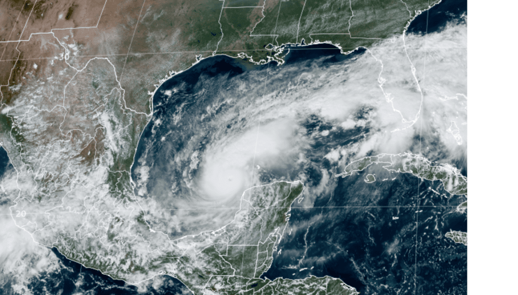
All eyes are on the Gulf of Mexico where this morning, Hurricane Milton explosively intensified into a category five hurricane with top winds of 175 mph! Winds in Milton increased 80 knots over the past 24 hours, making for the third fastest intensification on record, behind Hurricane Wilma in 2005 and Hurricane Felix in 2007.

NOAA/Colorado State University/RAMMB 10-07-24 1:00 pm CDT
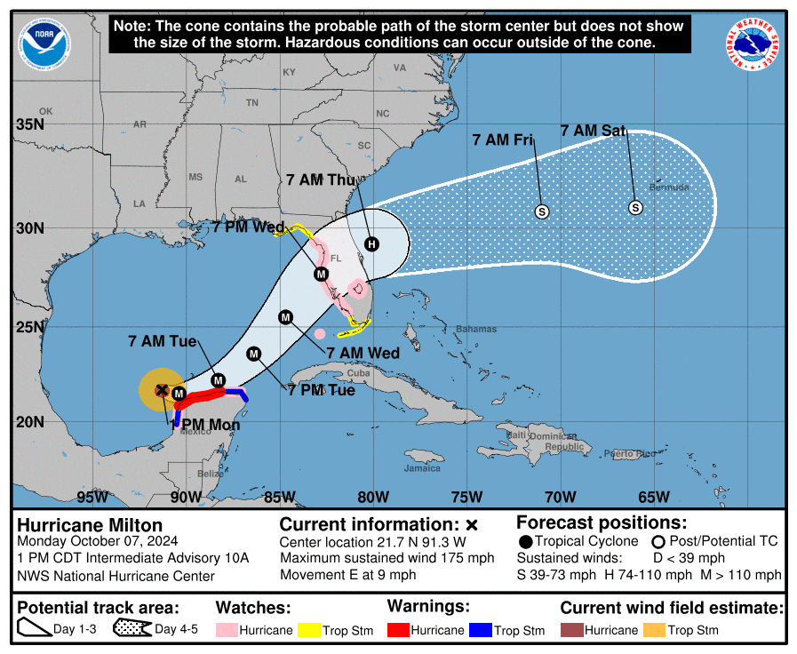
As of 1 pm CDT, the eye of Hurricane Milton was located by an Air Force Reserve Hurricane Hunter aircraft over the southern Gulf of Mexico, about 700 miles southwest of Tampa, Florida. Milton was moving toward the east near 9 mph. This general motion is expected today followed by a turn toward the east-northeast and northeast on Tuesday and Wednesday. On the forecast track, Milton is forecast to move near or just north of the Yucatan Peninsula today and Tuesday, then cross the eastern Gulf of Mexico and approach the west coast of the Florida Peninsula by Wednesday.
Data from NOAA and Air Force Reserve Hurricane Hunter aircraft indicate that the maximum sustained winds have increased to near 175 mph. Milton is a potentially catastrophic category 5 hurricane on the Saffir-Simpson Hurricane Wind Scale. While fluctuations in intensity are expected, Milton is forecast to remain an extremely dangerous hurricane through landfall in Florida on Wednesday.

Elsewhere, the National Hurricane Center is closely monitoring the progress of Hurricane Leslie, located over the central tropical Atlantic Ocean, and Post-Tropical Cyclone Kirk, located over the North Atlantic Ocean.
In the far eastern Atlantic, a tropical wave is expected to move off the west coast of Africa in a couple days. Afterward, environmental conditions appear marginally favorable for some slow development of this system while it moves westward or west-northwestward across the eastern tropical Atlantic. The system is expected to move near or over the Cabo Verde Islands on Thursday or early Friday. This system is forecast to eventually turn northwest into the open Atlantic.
Bob


Social Media