Another Week of Extreme Heat, but Changes Coming Next Week
SEPT. 5, 2023
We’re looking at another rough week of dry and very hot weather. But finally, there are some signs our extreme, never-ending summer might be finally be backing down. A change in the pattern is forecast to take place next week that will bring less hot weather along with a chance for rain.
But before we get to next week’s changing weather, more dry and very hot weather can be expected this week and through the upcoming weekend. The heat dome will again be the primary factor in our weather. Tuesday’s analysis shows the heat dome covering the south central U.S., with the center located over north central Mexico. Forecasts call for the center, or most intense part of the heat dome, to remain over Mexico today and Wednesday, then shift northeast to West Texas late week and through the weekend, bringing with it extreme temperatures.
For this afternoon and Wednesday, weather conditions will continue to be sunny and very hot! Thanks to the sea breeze and abundant tropical moisture, there will be a slight chance for a few scattered afternoon and evening rain showers and isolated thunderstorms across the coastal plains region, extending inland to La Grange. The probability for rain both days will be near 30 percent. For locations that do happen to see rain, totals will average less than a quarter inch. None of the rain activity is expected to make it to Central Texas or the Hill Country regions.
- High temperatures Tuesday and Wednesday are forecast to be between 101 and 103 degrees across the Hill Country and Central Texas regions, and between 98 and 101 degrees across the coastal plains.
Temperatures are forecast to trend even hotter Thursday through Sunday as the center of the heat dome moves north into West Texas.
- High temperatures Thursday through Sunday are forecast to be between 102 and 106 degrees across the Hill Country and Central Texas regions, and between 100 and 104 degrees across the coastal plains.
Parts of the Hill Country and Central Texas may see a slight chance for a few scattered rain showers Sunday as a weak wave of low pressure tracks southeast out of Oklahoma.
Forecasts call for the heat dome to begin weakening early next week as it slowly contracts southwest into Mexico. At the same time, a trough of low pressure is forecast to develop south out of central Canada the middle of next week, and this will allow for a cold front to push south into Texas during the middle and latter parts of next week.
The cold front is forecast to arrive sometime next Tuesday. This won’t be a “blue norther” by any means, but the front will bring less hot air into our region for the second half of the week and the following weekend.
The triple digit temperatures are forecast to come to an end next week as the heat dome moves away and the cold front spreads south. High temperatures Monday are still forecast to be near 100 degrees, but look to fall to the mid and upper 90s Tuesday, and to the mid-90s Wednesday through Friday.
The other big change for next week will be for an increasing chance for rain showers and thunderstorms Tuesday into Wednesday with the cold front. Forecasts call for fairly widespread totals close to a half inch, and possibly higher over the two-day period.
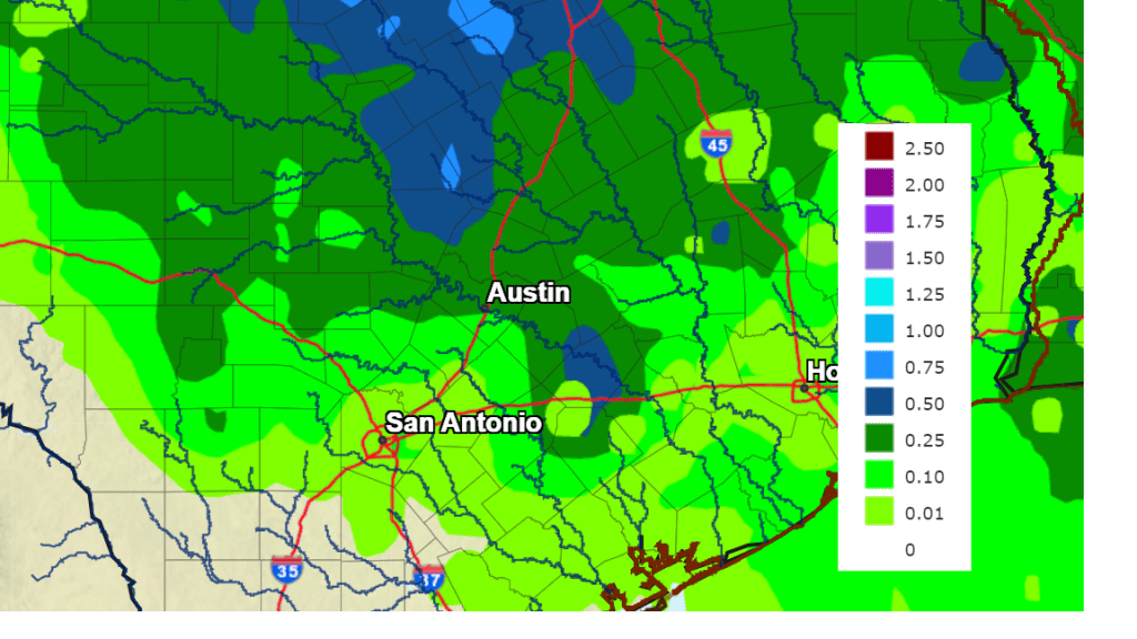
The National Weather Service’s 7-day rainfall forecast goes out to 7 pm next Tuesday. It doesn’t account for any rain next Tuesday night or Wednesday, but it gives us an idea about the increasing chance for rain.
NWS Rainfall Forecast for the Period 7 pm Tuesday through 7 pm next Tuesday:
Tropical Weather Outlook
Weather conditions are quiet across the Gulf of Mexico and the Caribbean Sea. There are no systems here which pose a threat for tropical development over the next seven days.
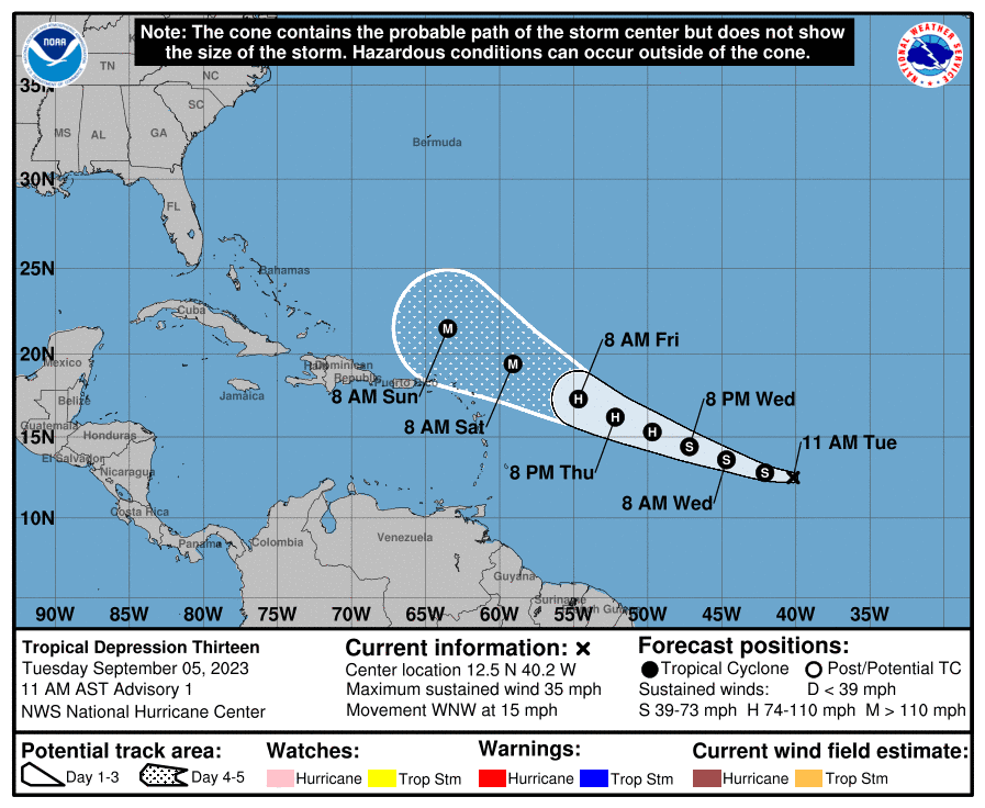
In the central tropical Atlantic, a new tropical depression formed Tuesday morning and is forecast to become a powerful hurricane by the end of the week. As of now, this system is expect to bend north of the Caribbean Sea and poses little threat to the western Gulf of Mexico.
As of 10 am CDT Tuesday, the center of Tropical Depression Thirteen was located about 1425 miles east of the Lesser Antilles. The depression was moving toward the west-northwest near 15 mph, and this motion is expected to continue for the next few days. Maximum sustained winds are near 35 mph with higher gusts. The depression is forecast to be a hurricane in a couple of days and could become a major hurricane in a few days.
Fire Weather Concerns
Near critical fire weather conditions continue over the Hill Country and the Interstate 35 corridor this week, and from the continued combination of above average temperatures, critically to extremely dry fuels, minimum relative humidity levels between 25 to 35 percent and south to southeasterly winds that increase each evening with inland advancement of the sea breeze.
Have a good week!
Bob
Social Media