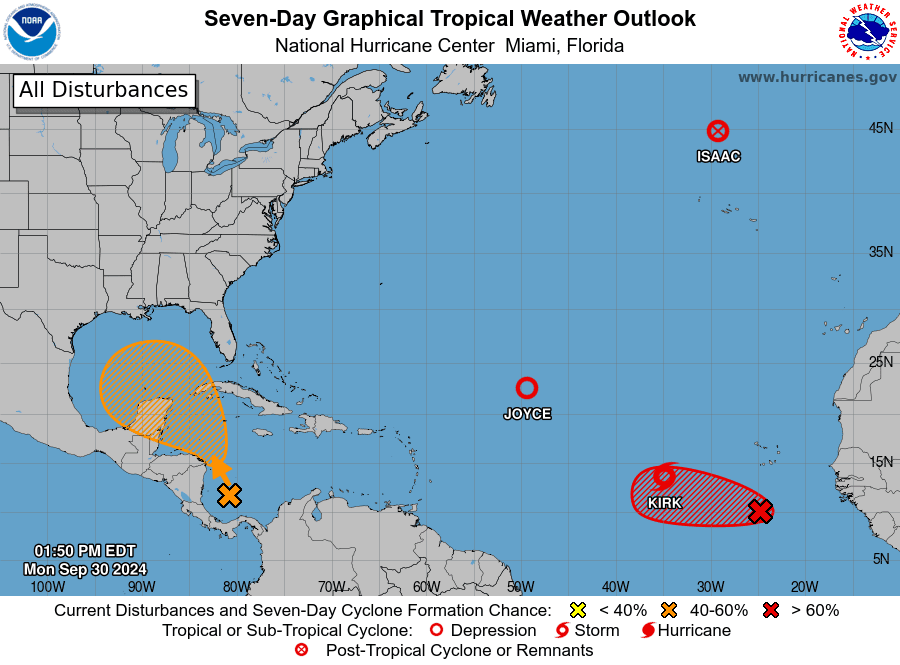
A trough of low pressure located over the southwestern Caribbean Sea continues to produce some disorganized shower and thunderstorm activity. National Hurricane Center forecasters indicate environmental conditions could become conducive for gradual tropical development, and a tropical depression could form in a few days while the system is over the southern Gulf of Mexico or northwestern Caribbean Sea.
While there is support for tropical development among the major computer forecast solutions, this support has been slowly weakening in the number of individual forecast members showing development. Atmospheric conditions in the upper atmosphere are not shaping up to be as favorable as they were last week with Helene. This week, there is quite a bit of dry air across the western Gulf of Mexico, and if this dry air gets pulled into the developing system, it would seriously limit development. The National Hurricane Center has lowered the probability for development from 50 percent, down to 40 percent over the next seven days.
Should a tropical system develop later this week, the majority of the forecast solutions call for the system to track northwest into the central Gulf of Mexico, then turn northeast and move toward Florida. As of now, this potential tropical system poses little threat to Texas.
A dry and quiet weather pattern remains in place across Texas. Our region remains under the influence of a broad, stable ridge of high pressure located across the western and southwestern U.S. The storm track is currently located across southern Canada. Forecasts call for the current dry and stable weather pattern to remain in place through late week and the upcoming weekend. Dry air looks to continue across the Hill Country and most of Central Texas through late week. However, higher moisture levels are predicted to return to the coastal plains region late week and through the upcoming weekend. A weak trough of low pressure tracking east across South Texas late week is predicted to bring a 30-40 percent chance for scattered showers and isolated thunderstorms to the middle Texas coast Friday into Saturday. Rain amounts, if any, are forecast to generally average between 0.25 and 0.5 inches. Elsewhere, no rain is forecast.
No significant change in the temperature is forecast this week.
- High temperatures Monday afternoon through Sunday are forecast to be in the upper 80s to low 90s across the Hill Country, and in the low and mid-90s across Central Texas and the middle Texas coast
- Low temperatures Tuesday through Sunday mornings are forecast to be in the low 60s across the Hill Country, in the mid-60s across Central Texas, and in the upper 60s to low 70s across the coastal plains
Looking ahead to next week, slightly cooler temperatures can be expected. Forecasts call for a dry cold front to spread south across the area next Monday. The front is forecast to bring with it dry and slightly cooler air that will be in place throughout the week. High temperatures next week are predicted to be in the upper 80s across the Hill Country and be around 90-92 degrees across the rest of the region. Unfortunately, no rain is expected next week and through the middle of the month as our region remains under the influence of stable high pressure.
Tropical Weather Outlook
In addition to the possible tropical disturbance over the southwestern Caribbean Sea, National Hurricane Center forecasters are monitoring the progress of Post-Tropical Storm Isaac located northwest of the Azores, Tropical Depression Joyce located over the central tropical Atlantic, and Tropical storm Kirk located over central tropical Atlantic. Both Joyce and Kirk are predicted to track to the northeast and pose no threat to the Gulf of Mexico.
NHC forecasters are monitoring an area of showers and thunderstorms over the eastern tropical Atlantic. Conditions are quite favorable for this system to develop into a tropical depression over the next couple of days as the system moves slowly westward.

Comet Tsuchinshan-Atlas
Astronomers are closely following the progress of a recently discovered comet which just moved around the sun. Now visible in the early morning sky, Comet Tsuchinshan-ATLAS is about to pass between Earth and the sun, shifting from the September morning sky to the October evening sky. The closest approach to Earth will be on October 12th. By then it could be a beautiful naked-eye comet that is as bright as a first-magnitude star at dusk. in 2007. Stay tuned over the coming days for further updates and where it will be visible in the evening sky.
Bob


Social Media