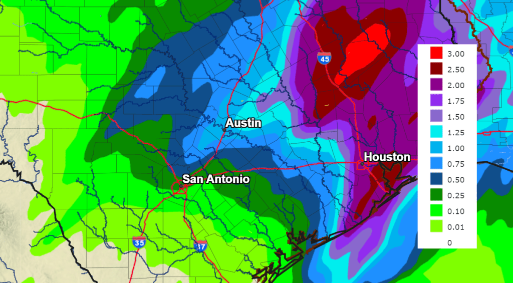
A trough of low pressure tracking northeast out of Mexico Sunday night caused the development of a large area of rain which slowly spread northeast across the region. Some of the heaviest rain was focused along the Interstate 35 corridor, where totals of 2-4.25 inches were recorded. Another area of heavy rain occurred southeast of Austin, where totals of 2-3.5 inches occurred over parts of Fayette, Austin, Lavaca, Colorado, and Wharton Counties. Unfortunately, most of the rain took a path along and east of Interstate 35, leaving the majority of the Hill Country with totals under a quarter of an inch.
As of early Monday afternoon, the rain had pushed east of Interstate 35. The rain is expected to end from west to east across Central Texas and the middle Texas coast mid-afternoon as the trough exits to the northeast. Clouds will decrease across parts of the Hill Country and parts of Central Texas, allowing for just a few peaks at the sun. The temperature will trend warmer Monday afternoon as the arctic moves out . High temperatures will range from the low and mid-50s across the Hill Country, to the mid-60s across the coastal plains.
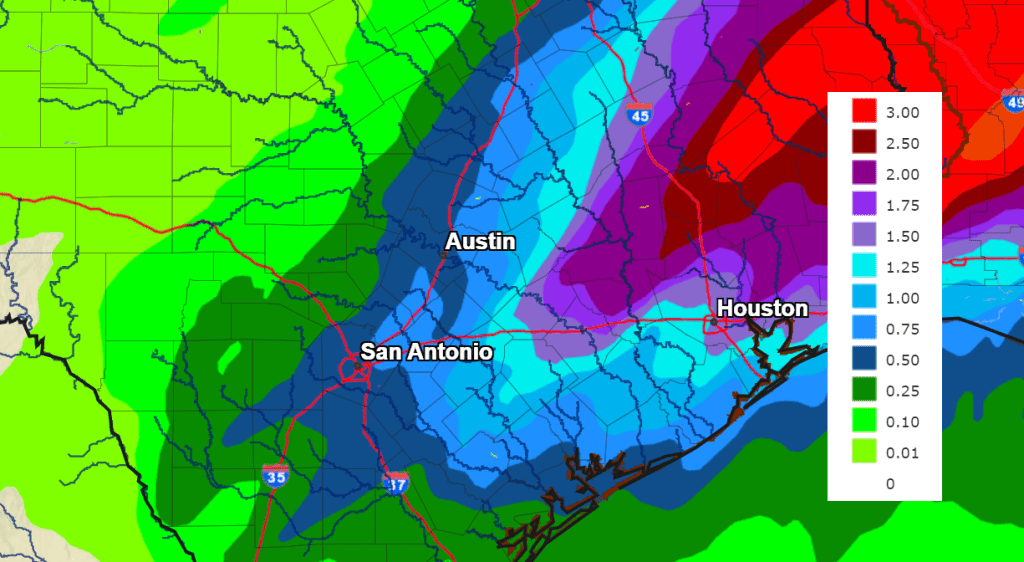
Attention turns to a second wave of low pressure that is predicted to lift northeast out of Mexico late Monday night into Tuesday morning. This trough is forecast to track across Texas, causing the widespread development of rain showers and scattered thunderstorms. But once again, the focus for the heaviest rain looks to occur over areas along and east of Interstate 35. High resolution forecasts call for showers and scattered thunderstorms to develop across West and South Texas late Monday evening, with the activity then spreading northeast across the Hill Country, Central Texas, and coastal regions after midnight Monday night. Some of the rain could be locally heavy—especially across the northern Hill Country and for areas along and east of I-35. The rain and thunderstorms are expected to push north and east of the region Tuesday afternoon. Do note there is a slight chance some of the thunderstorms Tuesday could be strong to severe. The Storm Prediction Center has placed the area along and east of a line stretching from Hondo, to Marble Falls, to Franklin, under a Marginal risk (a 1 out of 5 risk) for severe thunderstorms. The primary severe weather risks will be large hail and damaging winds.
Rain amounts from this next round of showers are predicted to be a little lower than what occurred Sunday night. Forecasts call for widespread totals of 0.5-1.5 inches across the northern Hill Country and for areas along and east of I-35. Some isolated totals up to 2 inches will be possible. Much of the central and southern Hill Country is forecast to see totals close to a half inch.
NWS Rainfall Forecast for the Period 6 pm Monday through 6 pm Tuesday:
Milder temperatures are predicted for Monday night and Tuesday. Expect lows in the low 50s, with highs in the mid-60s to low 70s.
A third round of rain showers and thunderstorms is forecast across the area from late Tuesday night through Wednesday afternoon as yet another trough of low pressure tracks northeast out of Mexico. This system is expected to bring another widespread area of rain showers and scattered thunderstorms to the region. The heaviest rain is predicted to again occur over areas along and east of Interstate 35. Totals from this next system are forecast to generally average between 1 and 1.5 inches for areas along and east of I-35. For areas to the west, most totals are forecast to average less than a half inch.
NWS Rainfall Forecast for the Period 6 pm Tuesday through 6 pm Wednesday:
Dry weather is forecast Wednesday night through Thursday night as the last of the troughs of low pressure exit to the northeast. High temperatures Wednesday and Thursday are predicted to be in the upper 60s to low 70s. Lows Thursday morning will be in the upper 40s to low 50s.
A 30 to 40 percent chance for scattered rain showers and isolated thunderstorm is forecast across the region Friday as a Pacific cold front moves across the region. Rain amounts Friday are forecast to average less than a quarter inch.
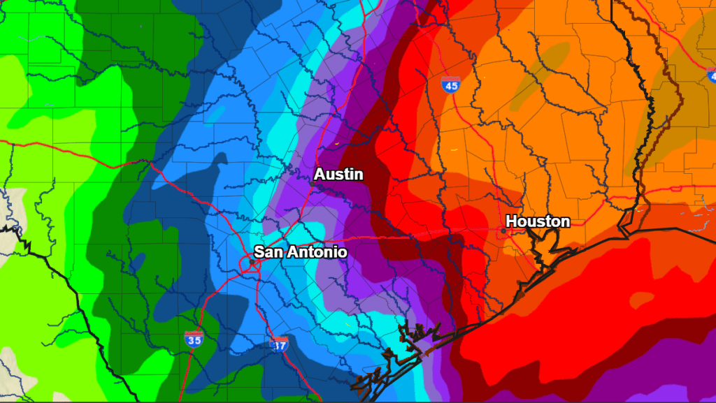
Total rainfall forecast through Friday afternoon ranges from around a half inch across the western Hill Country, to between 2 and 4 inches for areas between La Grange and Matagorda Bay.
NWS Rainfall Forecast for the Period 6 pm Monday through 6 pm Friday:
Mostly sunny, dry, and slightly cooler weather is forecast this weekend. Expect highs in the upper 50s, with lows in the mid and upper 30s. A freeze is not anticipated.
Looking ahead to next week, dry and mild weather is forecast. Expect daily high temperatures in the 60s, with lows in the 40s.
Bob
Social Media