An unusual July weather pattern is taking shape, with heat domes now situated across the western and southeastern U.S. and a rare cold front draped across Central and South Texas. This unusual pattern is forecast to strengthen next week, and is expected to bring a week-long wet weather pattern to much of Texas.
As of late Friday morning, the cold front stretched from Houston, to San Antonio, to near Ozona. Slightly drier and slightly cooler air was noted behind the cold front. The front is forecast to sag south to the middle Texas coast Friday evening and stall over that general area through Saturday . The front is then predicted to return back to the north on Sunday. With drier and somewhat more stable atmospheric conditions expected behind the cold front, no rain is forecast across the Hill Country or Central Texas regions through Sunday morning. For areas near and to the south of Interstate 10, there will a 40 percent chance for scattered rain showers and thunderstorms across the area this afternoon and again Saturday afternoon. Rain amounts through Saturday evening are forecast to average around a half inch, with isolated totals of 1-2 inches possible.
- Despite the “cold” front, high temperatures Friday and Saturday are predicted to generally be in the mid to upper 90s. Low 90s are forecast for the coastal region.
Significant moisture looks to return off the Gulf of Mexico to the eastern half of Texas beginning Sunday afternoon. As a result, there will be a 30-40 percent chance for scattered rain showers and thunderstorms across the region Sunday afternoon into Sunday evening. Rain amounts of 0.25 to 0.5 inches can be expected. Sunday’s weather will; include a partly to mostly cloudy sky.
A change to a wet and unsettled weather pattern is forecast to begin Sunday afternoon into Sunday night when a trough of low pressure situated between the two heat domes builds south into West Texas out of the southern Plains states. Waves of low pressure are predicted to move through the broad trough and track east across Texas next week, with each trough expected to kick off showers and thunderstorms. The unusual trough is forecast to remain in place across West Texas through late next week, and is expected to keep the wet pattern going through next Friday.
Forecast solutions are showing the first wave of low pressure to spread east out of West Texas late Sunday into Monday. Showers and scattered thunderstorms are forecast to increase across the region Monday morning, followed by a fairly widespread coverage of rain Monday afternoon into Monday evening. The probability for rain will be near 70-80 percent. Rainfall forecast for Monday call indicate widespread totals of 1-1.5 inches will be possible.
A second wave of low pressure is forecast to spread across the region Tuesday, bringing more widespread moderate to heavy rain to the region. The probability for rain will again be near 70-80 percent. Rain amounts Tuesday are predicted to average around 1 inch.
Forecasts call for additional waves of low pressure to move across the area next Wednesday into Friday. With a very moist air mass in place, additional periods of moderate to occasionally heavy rain is forecast. There are some signs the rain may trend down a bit in intensity and coverage next Thursday and Friday. The chance for rain is forecast to decrease by next weekend as the stalled trough of low pressure finally exits to the northeast.
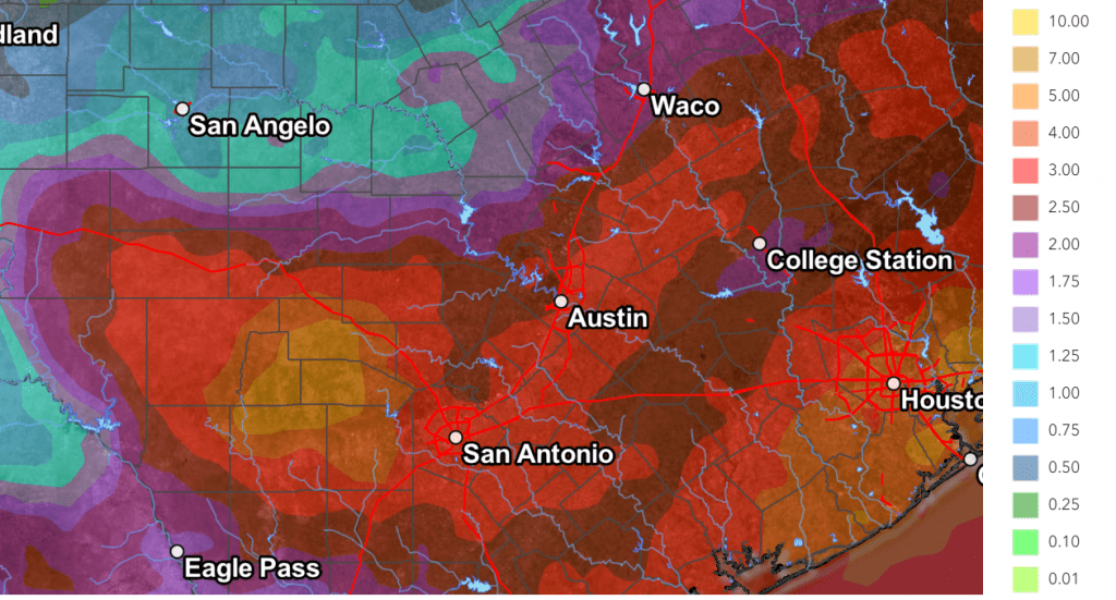
Note that next week’s rains are expected to be slow-moving efficient rain producers and will be capable of producing large amounts of rain in a short period of time. The Weather Prediction Center’s 7-day rainfall forecast, valid through 7 pm next Friday, calls for widespread totals of 2-4 inches, with isolated totals of 4-6 inches possible.
NWS Rainfall Forecast Valid through Next Friday at 7 pm:

Next week’s pattern will feature considerable clouds, periods of rain, and lower temperatures. High temperatures Monday through Friday are forecast to generally be around 88-90 degrees.
Looking out to next weekend and the week of July 29th, a drier and warmer pattern is forecast as the western heat dome shifts closer to Texas. High temperatures are forecast to generally be in the mid to upper 90s.
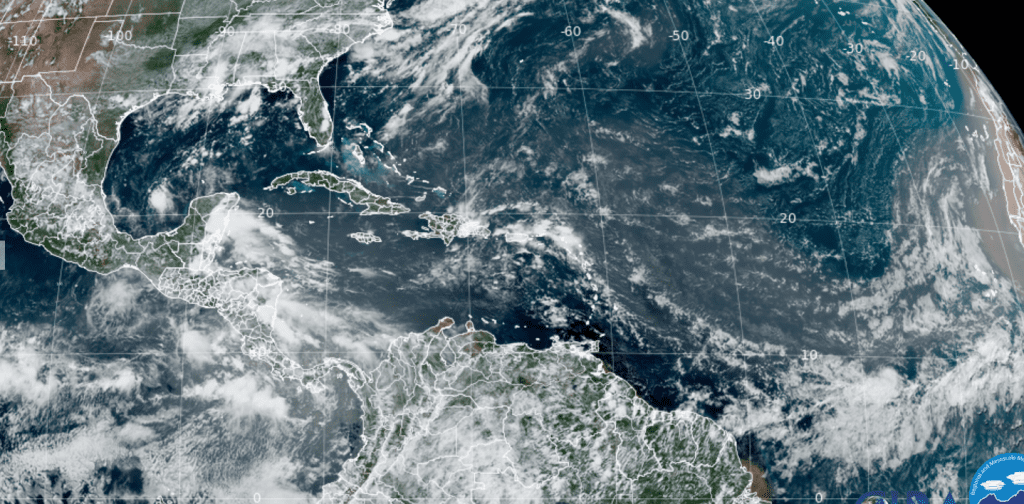
Tropical Weather Outlook
Weather conditions are very quiet across the tropical Atlantic and they are expected to remain that way for at least the next seven days.

NOAA/Colorado State University/RAMMB 07-19-24 1:10 pm
The July Full Moon
Don’t miss the Full Buck Moon this weekend. Technically, the moon will be full Sunday morning at 5:17 am CDT. This means we will be treated to a full-looking moon Friday, Saturday, and Sunday nights. By the way, July’s full Moon is traditionally called the “Buck Moon” due to the fact that deer antlers are seen around this time of year in North America.
Have a good weekend!
Bob


Social Media