Highlights:
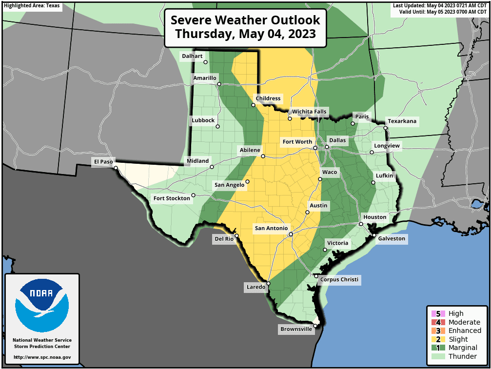
- There is a Level 2 of 5 Risk (Slight Risk) for severe storms late this afternoon and evening across the Hill Country and Central Texas.
- The primary window for severe storms will be between 4 pm and midnight.
- Large hail and damaging winds will be today’s primary severe weather threats.
- Forecast confidence is low regarding coverage and exact placement of storms, however any storms that form will be capable of producing large hail and damaging winds.
A partly to mostly cloudy sky will be in place across the region today. Mid to late afternoon, all eyes will be focused on the Edwards Plateau and Rio Grande Plains regions where an area of scattered thunderstorms are forecast to develop along the dry line. An approaching trough of low pressure moving out of Mexico is expected to help initiate thunderstorm development. The thunderstorms will be developing in a moist and fairly unstable atmosphere that will allow the storms to become strong to severe.
High resolution forecasts call for scattered thunderstorms to develop over the area between Del Rio, Menard, and Brownwood sometime between 3 and 4 pm, with the thunderstorms then spreading east across the Hill Country late afternoon into the early evening. Some of the storms are forecast to spread into the Austin/Interstate 35 corridor between 7 pm and 10 pm. Should the storms still be holding together, they could reach the area between Bastrop and La Grange sometime between 10 pm and midnight.
The Storm Prediction Center has placed the Hill Country and most of Central Texas, including the Austin metro area, under a Slight Risk (a 2 out of 5 risk) for severe thunderstorms late this afternoon through tonight. The area between Smithville and Wharton has been placed under a Marginal Risk (a 1 out 5 risk) for severe thunderstorms overnight. Today’s primary severe weather threats will be large hail and damaging winds.

Rain amounts from today’s storms are forecast to average between 0.25 and 0.5 inches. However, some isolated totals of 1-2 inches will be possible.
All of the thunderstorm activity is forecast to diminish shortly after midnight tonight.
A somewhat similar pattern is forecast to repeat on Friday. Scattered thunderstorms are predicted to develop across the Hill Country in the mid to late afternoon and spread to the east in the late afternoon and evening. However, storm coverage is expected to be a little less. The probability for rain and storm development across the region will be around 30 percent.
Bob


Social Media