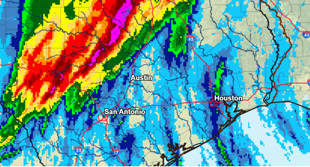
A slow moving area of rain showers and thunderstorms brought significant rain to the Hill Country and Interstate 35 corridor Wednesday night into Thursday morning. On average, totals since early Wednesday have averaged between 1 and 3 inches. However, a large swath of 6 to 8 inch totals occurred over the area between Junction and Lampasas. (see map of estimated rainfall totals at the bottom). In addition to the heavy rain, this line of storms also produced a couple of brief tornadoes over the area between San Antonio and Austin.
As of noon, the rain had ended across most of the Hill Country. The line of moderate to heavy rain showers and thunderstorms was located just to the east of Interstate 35, from east of Waco, to just east of Austin, to east of San Antonio. The line was moving very slowly to the east. Waves of moderate to heavy rain and scattered thunderstorms are forecast to continue across the Austin metro and the I-35 corridor trough mid-afternoon. The National Weather Service has posted a Flood Watch for Travis, Hays, Williamson, and Comal Counties through Thursday evening. Additional totals of 1-2 inches, along with isolated amounts to near 3 inches will be possible across these counties. A Flood Watch has also been posted for Llano, Burnet, Edwards, Kerr, Gillespie, Kendall, Blanco and Comal Counties through this evening where excessive runoff from Wednesday night’s heavy rain may result in flooding of rivers, creeks, streams, and other low-lying and flood-prone locations.
High resolution forecasts call for the line of rain to shift a little further east in to parts of Bastrop, Fayette, Lee, and Caldwell Counties by mid-afternoon. Waves of moderate to heavy rain can be expected, with general totals in the range of 1-2 inches. The rain should slowly taper off late afternoon into early evening.
For the middle Texas coast, showers and scattered thunderstorms are predicted to increase in areal coverage through the afternoon and continue through late evening. The rain is forecast to decrease after 10 pm. Totals of 0.5 to 1 inch are forecast.
Some additional light rain showers will be possible across the eastern Hill Country through late afternoon.
Thursday night, only a slight chance for rain showers and isolated thunderstorms is forecast.
Friday’s weather will feature a mostly cloudy sky, with an increasing chance for scattered rain showers and isolated thunderstorms across the region in the afternoon and evening. Friday’s rain is not expected to be as heavy, with rain amounts averaging between a quarter and a half inch.
A slight chance for rain is predicted for Saturday with a partly to mostly cloudy sky. Rain amounts should average less than a quarter inch.
The next significant chance for rain looks to take place Sunday afternoon through Monday along and behind a strong Canadian cold front. The front is predicted to arrive Sunday afternoon, the push into the Gulf Sunday evening. Light rain showers will continue behind the cold front Monday, then taper off Monday night into Tuesday morning. Totals through the period are forecast to generally average between 0.25 and 0.5 inches.
Much colder temperatures are forecast behind Sunday’s cold front. High temperatures Monday through Wednesday are forecast to be in the 50s. Lows Tuesday through Thursday mornings are predicted to be in the low and mid-30s across the Hill Country , in the mid and upper 30s across Central Texas, and in the upper 30s to low 40s across the coastal plains! Much of the Hill Country is forecast to see a light freeze next week.
NWS Estimate of Rain Falling Between 7 am Wednesday and 7am Thursday:
Bob
Social Media