A Strong Cold Front To Arrive Sunday Afternoon. Colder Temperatures Expected Next Week
OCT. 27, 2023
The threat for heavy rain, similar to what occurred Wednesday night into Thursday across the Hill Country and Central Texas regions, has ended. The trough of low pressure responsible for the slow-moving line of rain showers and thunderstorms exited Texas Thursday evening. This was quite a rain event, with many locations seeing more than the normal rainfall for all of October falling in less than 24 hours. It should be noted, the rain diminished before reaching the middle Texas coast Thursday. Areas south of Interstate 10 saw little to no rain over the past three days.
Scattered rain showers and isolated thunderstorms are forecast to continue across the region this afternoon and evening in the wake of Thursday’s storm system. The combination of a very moist atmosphere and a couple of weak waves of low pressure drifting north out of South Texas is expected to cause the development passing showers and a few isolated thunderstorms. Widespread, heavy rain and severe storms are not anticipated. Rain amounts through Friday evening should average less than a half inch, with a couple of isolated heavier totals. Under a partly to mostly cloudy sky, afternoon temperatures should warm to the mid and upper 80s.
A weak cold front, currently located across Northwest Texas, is forecast to sag south and stall over the area between Brownwood and San Angelo Friday evening. Forecasts call for moderate rain and scattered thunderstorms to develop over this general area Friday night. Some of this rain activity could spread into parts of the northern Hill Country overnight, but the rain should stay north of the rest of the region.
Friday night, there will be a 20-30 percent chance for a few scattered rain showers and isolated thunderstorms across the Hill Country, Central Texas, and the middle Texas coast. Rain amounts should stay below a quarter inch.
Saturday through Saturday night, a 20-30 percent chance for scattered rain showers and isolated thunderstorms will continue. For areas that do see rain, totals are forecast to average around a quarter inch or less. Saturday‘s high temperature is forecast to be in the mid-80s.
BIG WEATHER CHANGE
The much talked about strong cold front is forecast to sink south into Northwest Texas early Sunday morning. The front is predicted to move across the Hill Country and Central Texas regions Sunday afternoon and the coastal plains region Sunday evening. Ahead of the cold front, temperatures are forecast to warm into the 70s across the Hill Country and into the 80s across Central Texas and the coastal plains.
Scattered rain showers and thunderstorms look to accompany the frontal boundary as it pushes south through the area. Behind the cold front, an overrunning pattern of widespread clouds and periods of light to moderate rain is forecast beginning Sunday evening, continuing through Monday night. A trough of low pressure responsible for the overrunning pattern is predicted to move east of our area Tuesday, and this should end the chance for rain. Rain amounts between Sunday evening and Tuesday morning are forecast to generally average between 0.25 and 0.5 inches. However, some isolated totals to near 1 inch will be possible. The rain should end well before trick-or-treat activities Tuesday evening. A dry weather pattern is forecast to take shape Tuesday afternoon and continue through late next week.
Blustery conditions will develop behind the cold front beginning Sunday afternoon/evening, and continue through Tuesday. Behind the front Sunday afternoon and Sunday night, northerly winds are forecast to increase to 20-30 mph, with gusts of 35-40 mph. These windy conditions are forecast to continue Monday into Tuesday.
Sunday’s cold front is going cause a huge change in the temperature! The coldest air so far this fall is on the way. Confidence has increased this front will bring the first freeze of the season to the Hill Country and a few parts of Central Texas next Wednesday and Thursday mornings. It’s going to be quite cold at all other locations as well. Make preparations this afternoon and this weekend to protect any tender vegetation.
Here is a breakdown of expected temperatures next week:
Monday
Lows Monday morning will include the mid and upper 30s across the Hill Country, the low 40s across Central Texas, and the upper 40s across the coastal plains. High temperatures will be in the mid-40s across the Hill Country and Central Texas regions, and be around 50 degrees across the coastal plains.
Tuesday
Lows Tuesday morning will include the upper 30s across the Hill Country, the low 40s across Central Texas, and the low to mid-40s across the coastal plains. High temperatures will be in the mid-50s.
Wednesday and Thursday
Lows Wednesday and Thursday mornings will be near 28-32 degrees across the Hill Country, in the mid-30s across Central Texas, and in the upper 30s to low 40s across the coastal plains. High temperatures will be in the mid and upper 50s Wednesday and in the low 60s Thursday.
Slightly milder readings are forecast for Friday and next weekend.
For any trick or treaters out on Halloween/Tuesday evening, it will be chilly evening, with temperatures in the upper 40s. Plan on costumes with layers.
Tropical Weather Update
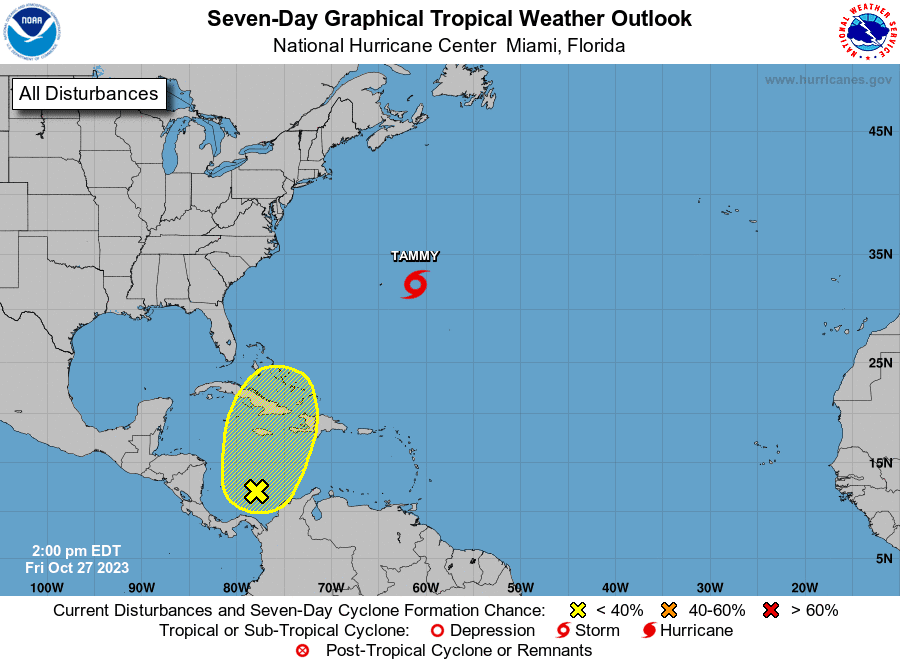
The National Hurricane Center has re-initiated advisories on Tropical Storm Tammy, located a couple of hundred miles east of Bermuda. Tammy became extratropical Thursday, but a recent change in structure has allowed the system to evolve back into a tropical storm. Forecasts call for Tammy to move east-southeast over the open water and dissipate sometime early next week.
NHC forecasters note a broad area of low pressure has formed over the southwestern Caribbean Sea. Environmental conditions could support some slow development of the system during the next several days while it moves generally northward. This system poses no threat to the western Gulf of Mexico. NHC forecasters are giving this system a 30 percent chance for tropical development over the next seven days.
The October Hunter’s Moon
Full Moon will occur at 3:24 pm CDT Saturday. As a result, the moon will appear full Friday, Saturday and Sunday nights.
As twilight deepens Saturday evening and the Moon climbs higher, note the planet Jupiter will be shining just 3° or so below or lower left of the moon. Watch them appear to draw closer together through the night. Jupiter will pass 2° below the brilliant Moon in the early morning hours of Sunday.
Have a good weekend.
Bob
Social Media