There was little to no frozen precipitation across the region Thursday night into Friday morning. Weather conditions are currently quiet, but very cold temperatures remain in place. Friday’s satellite images show a large area of clouds covering all of South, Central and East Texas as an weak overrunning pattern continues. No rain is expected this afternoon. With widespread clouds in place, only a slight rise in the temperature is expected this afternoon. High temperatures are forecast to be in the mid-30s across the Hill Country, be in the upper 30s to 40 degrees across Central Texas, and in the low to mid-40s across the coastal plains. A north wind at 10-15 mph, with occasional gusts to 25 mph will continue through late afternoon.
Scattered light rain showers and drizzle are forecast to develop beginning around midnight Friday night and continue into Saturday morning across the region as moisture levels increase ahead of a trough of low pressure over the southern Rockies. Temperature forecasts call for the readings to remain above freezing across Central Texas and the coastal plains Friday night, meaning the precipitation should remain all liquid. However, readings are forecast to fall to, or just below freezing across parts of the Hill Country early Saturday morning. Here, light rain, light freezing rain, and freezing drizzle are forecast. The most favored area for the freezing precipitation is forecast to be across the northern Hill Country between San Angelo and San Saba, extending south to Mason, Llano and Fredericksburg. Very light ice accumulations can be expected, potentially causing slippery and hazardous driving conditions—mainly on bridges and overpasses.
Weather outlook for 8 am Saturday:
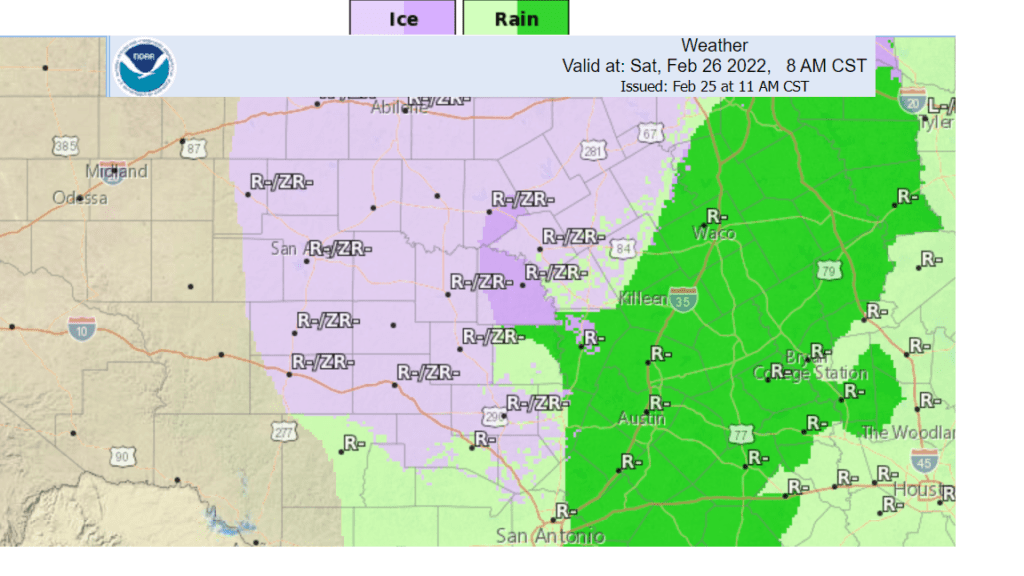
- Lows Saturday morning are forecast to be near 30-32 degrees across the Hill Country, be in the mid-30s across Central Texas, and be near 40 degrees across the coastal plains.
A steady, light rain or drizzle is forecast to occur across the entire region Saturday through Saturday evening as the overrunning pattern strengthens. The most concentrated area of rain is expected to occur across Central Texas and the Interstate 35 corridor. Temperatures across the Hill Country are predicted to rise above freezing mid to late morning Saturday, allowing the threat for ice to diminish. Elsewhere, just a slow warmup in the temperature is forecast.
- High temperatures Saturday are predicted to be in the low 40s across the Hill Country and Central Texas regions, and the mid to upper 40s across the coastal plains.
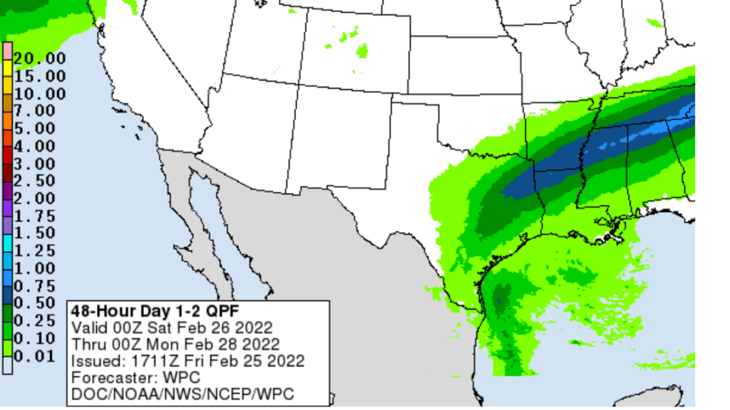
The rain is predicted to taper off from northwest to southeast after midnight Saturday night through mid-morning Sunday. Rain totals between Friday night and Sunday morning are forecast to generally average between a quarter and a half inch across Central Texas, For the Hill Country and the middle Texas coast, Totals are forecast to be near or less than a quarter inch. Lows Sunday morning will range from the low 30s across the Hill Country, to the low 40s across the coastal plains.
NWS Rainfall Forecast for the Period 6 pm Friday through 6 pm Sunday:
The rain is forecast to exit the coastal plains Sunday morning. Sunny and warmer weather is forecast across the entire region Sunday afternoon, followed by clear and chilly conditions Sunday night.
- Sunday’s temperature is forecast to warm to the upper 50s.
- Lows Monday morning will include the mid and upper 20s across the Hill Country, the lower 30s across Central Texas and middle 30s across the coastal plains.
Sunny, dry, and warmer weather is forecast next week as a ridge of high pressure spreads over Texas our of northern Mexico. High temperatures are forecast to be in the upper 60s Monday, warming to around 70-74 degrees Tuesday through Friday. Low temperatures are forecast to generally be in the 40s.
Looking out over the next two weeks, no additional arctic air is expected across our region.
Have a good weekend.
Bob
Social Media