Breezy and much cooler weather will develop this weekend as a strong cold front moves across the area Saturday afternoon. This front is expected to bring a freeze to the Hill Country and most of Central Texas Monday morning.
Before that happens though, we’re looking at a period of very mild weather this afternoon through Saturday morning. A widespread area of low clouds developed across the region late Thursday night into Friday morning thanks to a moderate wind flow off the Gulf of Mexico. These clouds are expected to break around midday, with the sky becoming partly cloudy. Friday’s weather will be breezy and warm, with high temperatures forecast to be in the upper 70s to low 80s. Southerly winds with speeds of 10-15 mph and occasional gusts to 25 can be expected. Lows Saturday morning will range from the low and mid-50s across the Hill Country, to the mid and upper 60s near the coast.
All eyes are on a Canadian cold front that is currently situated across the southern Rockies and southern Plains. The front is currently nearly stationary. However, a trough of low pressure lifting northeast out of the Desert Southwest tonight and Saturday is expected to give the front a push to the south. Forecasts call for the cold front to reach the northern Hill Country mid to late morning, the Austin and Interstate 35 corridor early to mid-afternoon, and the coastal plains region in the late afternoon to early evening. The atmospheric setup ahead of and along the cold front does not appear favorable for the development of any rain when the front moves across the Hill Country. However, there will be a 30-40 percent chance for scattered rain showers and isolated thunderstorms for areas south of Interstate 10 Saturday evening. Totals, if any, are forecast to remain below a quarter inch.
Saturday’s weather will feature early morning low clouds, followed by mostly sunny conditions late morning through the afternoon. High temperatures Saturday are forecast to be in the mid and upper 70s. Behind the cold front, northwesterly winds are predicted to increase to a range of 10-15 mph, with cooling temperatures.
Saturday night, the sky will clear as northerly winds increase to 10-20 mph, with gusts to 35 mph. The temperature will turn noticeably cooler. Los Sunday morning will range from the low and mid-30s across the Hill Country, to the low 40s across Central Texas, to the mid-40s across the coastal plains. Preparations should be made today to secure any loose Christmas decorations.
Sunday’s weather is shaping up to be sunny, breezy and cool as Canadian high pressure settles into the state. Strong northwesterly breezes will continue all day, with gusts to near 30 mph. High temperatures will only be in the mid and upper 50s.
Clear and cold weather is forecast Sunday night as the wind begins to subside. As mentioned earlier, conditions appear favorable for the temperature to drop to or just below freezing across the Hill Country, most of Central Texas and the northern portion of the coastal plains. Recent forecast data has trended cooler for the region.
- Lows Monday morning will include the upper 20s to low 30s across the Hill Country, and the low and mid 30s across Central Texas and the middle Texas coast.
For next week, a mostly sunny to partly cloudy sky is forecast Monday and Tuesday. The temperature will trend milder, with highs in the low and mid-60s. Lows Tuesday morning are predicted to be in the upper 30s. Lows Wednesday morning are predicted to be in the upper 40s to low 50s.
The weather pattern is forecast to become more unstable Wednesday through Friday. Forecasts call for a trough of low pressure to sink south into the Desert Southwest mid week, with the trough slowly pushing to the east Thursday through next Saturday. This system is forecast to cause a mostly cloudy sky across the region the second half of next week. In addition, this system is expected to cause the development of scattered rain showers across the region Wednesday through Friday, with most favorable area for rain being across the Hill Country. There is some possibility this system could linger into next weekend, prolonging the chance for rain.
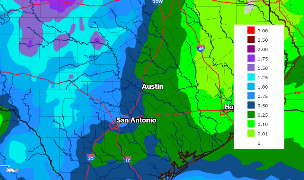
Rain amounts over this period are currently forecast to be between 0.5 and 1 inch across the Hill Country, and around 0.5 inch or less at most other locations.
NWS Rainfall Forecast for the Period 6 pm Friday through 6 pm Next Friday:
Temperatures Wednesday through Friday will feature highs in the 60s and lows in the 40s.
Have a good weekend.
Bob
Social Media