Spring-like temperatures will continue this week as a series of Pacific cold fronts move across Texas. Unfortunately, none of the fronts are expected bring significant rain. The first of the cold fronts is expected to move across our region late Monday night into Tuesday morning. In advance of the cold front, moisture levels are increasing thanks to a moderate flow off the Gulf. This will result in the mostly cloudy sky. A spotty light shower or two will be possible for areas east of Interstate 35 through Monday evening. Monday’s high temperature is predicted to reach near 78-80 degrees.
The Pacific cold front is forecast to reach West Texas late Monday evening and move across the Hill Country roughly between 4 and 6 am Tuesday. The front is expected to spread across the Austin/I-35 corridor between 6 and 8 am, the Intestate 10 corridor between 9 am and noon, moving off the middle Texas coast by early afternoon. Atmospheric conditions appear to be most favorable for shower and thunderstorm development with the cold front over North and Northeast Texas. However, forecasts call for a thin line of showers and isolated thunderstorms to develop along the cold front when it tracks east across the Hill Country and Central Texas regions. A stable layer in the middle atmosphere is expected to limit the development of severe storms across the Hill Country, Central Texas, and coastal regions. However, one or two of the thunderstorms may be strong with gusty winds.
Since the front and the area of rain will be moving so quickly, rain amounts are predicted to remain below a quarter inch.
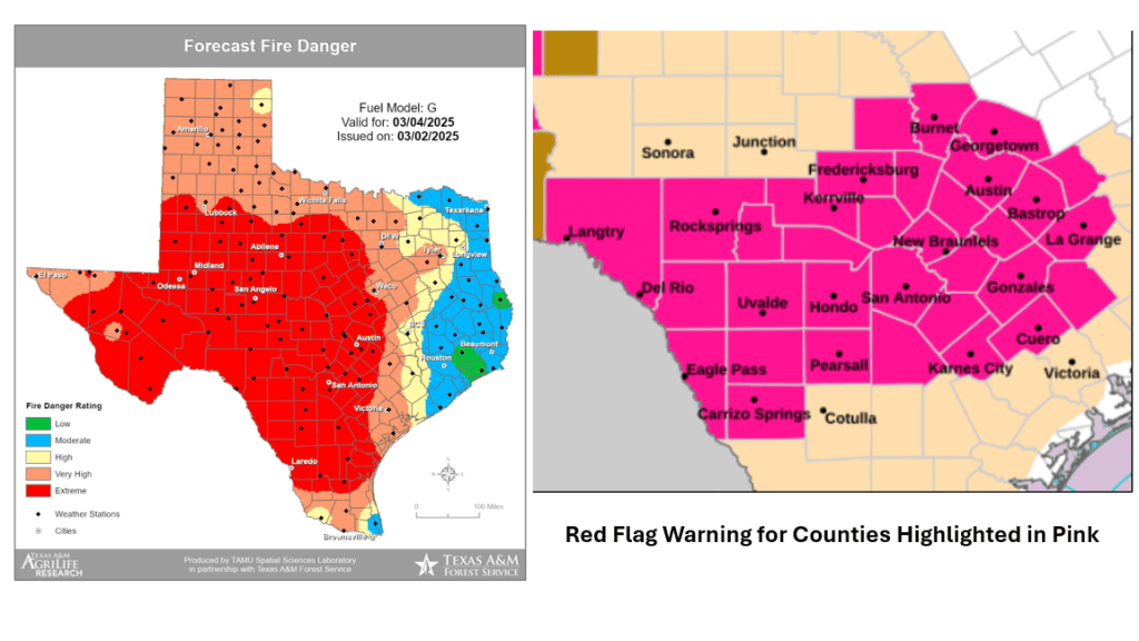
Behind the cold front, the sky will clear as mild and much drier air arrives. The wind will shift to the west and northwest with sustained speeds of 25-35 mph. Due to a strengthening pressure gradient, gusts of 40 to 50 mph are forecast across the Hill Country and Central Texas regions through Tuesday afternoon. Gusts to near 40 mph are predicted for the coastal plains. In addition to the windy conditions, the air on Tuesday will be unusually dry. Forecasts call for relative humidity levels to fall to a range of 5-15 percent across the Hill Country and Central Texas regions, and between 15 and 20 percent across the coastal region.
The strong winds and very low humidity levels will combine to create a very high to extreme fire danger across the entire region. Because of this, the National Weather Service has posted a Red Flag Warning for the Hill Country, all of Central Texas, and much of West Texas Tuesday morning through Tuesday afternoon. A Red Flag Warning means that critical fire weather conditions are either occurring now, or will shortly. The combination of strong winds, low relative humidity, and warm temperatures can contribute to extreme fire behavior. Residents are urged to exercise care with respect to all outdoor activities that could inadvertently cause wildfires.
Wind speeds are forecast to decrease and humidity level increase after sunset on Tuesday. This should gradually reduce the extreme fire weather threat.
Areas of blowing dust are forecast across much of West Texas, the Edwards Plateau, and the western Hill Country Tuesday. Under a sunny sky, high temperatures are forecast to be in the low and mid-70s.
A cooler, drier airmass will settle across the region late Tuesday into Thursday as northwesterly winds prevail behind Tuesday’s cold front. Expect a sunny to mostly sunny sky both days.
- High temperatures Wednesday and Thursday are forecast to be in the upper 60s
- Low temperatures Wednesday morning are predicted to be in the mid-40s across the Hill Country, with upper 40s at most other locations
- Lows Thursday morning are forecast to be in the low 40s at most locations
Mostly sunny and much warmer weather is forecast Friday as southerly breezes return to the area. Expect high temperatures in the low 80s.
Forecasts call for a weak Canadian cold front to move across the area late Friday night into Saturday morning. As of now, atmospheric conditions appear unfavorable for the development of rain along the front. Sunny and slightly cooler weather is forecast Saturday and Sunday.
- High temperatures Saturday and Sunday are predicted to be near 68-72 degrees
- Low temperatures Saturday morning will range from the upper 40s across the Hill Country, to the upper 50s near the coast
- Lows Sunday morning will include the upper 30s across the Hill Country, the low 40s across Central Texas, and the mid-40s across the coastal plains
The outlook for next week calls for mostly sunny and dry weather throughout the week as the storm track remains well to the north of Texas. Daily high temperatures are forecast to be in the low 80s, with lows generally in the 50s.
There are still no signs of any arctic air spreading into our region over the next 2-3 weeks.
Time Change Weekend
Daylight Saving Time begins this Sunday, March 9th, at 2 am. Remember to “spring forward” and set all clock ahead one hour before going to bed Saturday night. After the time change, there will be more light in the evening and less light in the morning.
Have a good week.
Bob
Social Media