The trough of low pressure responsible for rounds of rain earlier this week finally exited our region Thursday, ending the threat for additional heavy rain. However, a separate low pressure trough dipping south from the southern Rockies looks to move just close enough to bring our region one more chance for rain before the weekend. Rain from this next system isn’t expected to be anywhere near as heavy as the rain that fell earlier this week.
Foggy conditions Friday morning will give way to a cloudy to mostly cloudy sky Friday afternoon. Forecasts call the next trough of low pressure to track east across the Texas Panhandle and Northwest Texas regions Friday afternoon and Friday night, then shift east to the middle Mississippi Valley late Saturday. Atmospheric lift out ahead of the trough is expected to cause an area of scattered light showers and a few isolated thunderstorms to spread across the northern half of Texas, including the northern Hill Country, Friday afternoon into Friday evening. The probability for rain will be near 50 percent. Across the remainder of the Hill Country, Central Texas and the middle Texas coast, a slight chance for spotty rain showers and a couple of isolated thunderstorms is forecast from late Friday afternoon through Friday evening as moisture increases ahead of the upper trough. The probability for rain will be around 40 percent.
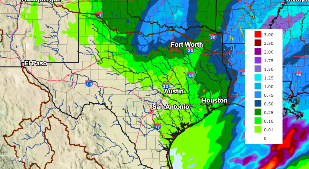
Rain amounts, if any, are forecast to only average around a tenth of an inch.
NWS Rain Forecast for the Period 6 pm Friday through 6 pm Saturday:
The chance for rain is predicted to end from west to east late Friday evening and toward midnight when a Pacific cold front pushes to the east out of West Texas, bringing drier and more stable air. Behind the cold front, northwesterly winds are forecast to increase to a range of 10-20 mph.
- High temperatures Friday are forecast to be in the low 60s across the Hill Country and Central Texas regions, with mid and upper 60s expected towards the coast.
- Low temperatures Saturday morning will range from the mid-40s across the Hill Country, to the mid-50s across the coastal plains.
On Saturday, widespread low clouds are forecast through the morning hours, but sunny weather will develop in the afternoon. A strong pressure gradient behind the cold front will cause breezy northwesterly winds with speeds of 10-20 mph and occasional gusts to 30 mph. The wind is expected to decrease to around 10-15 mph Saturday evening and Saturday night. Sunny and less breezy weather looks to follow on Sunday. Expect some chilly temperatures Saturday and Sunday nights.
- High temperatures Saturday are forecast to be around 58-60 degrees.
- Lows Sunday and Monday mornings will include the mid-30s across the Hill Country, the upper 30s across Central Texas, and the upper 30s to low 40s across the coastal plains.
- High temperatures Sunday are forecast to be in the low 60s.
Mostly sunny, dry, and mild weather is forecast all of next week as stable ridge of high pressure spreads over Texas from the western U.S. Expect daily high temperatures to be in the upper 60s. Low temperatures are forecast to be in the mid and upper 40s.
Beginning late Friday, continuing through next Saturday, there will be an increasing chance for rain showers and scattered thunderstorms across the region when a large Pacific trough of low pressure moves from the Desert Southwest to the southern Plains states. Forecasts currently call for totals to average around a half inch. These totals could trend a little higher as we get closer to next weekend.
Looking further ahead, little change in the temperature is forecast for the first full week of February.
Have a great weekend!
Bob
Social Media