There will be a couple more opportunities for rain and thunderstorms tonight and Saturday, before a dry, hot, and very summer-like pattern begins to set up on Sunday. This upcoming pattern is expected to bring the hottest temperatures so far this year. Most locations are expected to see a series of triple-digit readings throughout the week and into next weekend as an early-season heat takes shape. Long-range forecasts suggest the very hot temperatures might moderate down a few degrees staring around June 21 or 22.
Those working or spending time outside will definitely want to take needed heat safety precautions with the change to triple digit temperatures next week.
After this weekend, little to no rain is expected over the next week to ten days.
Here’s a breakdown of the weather through late next week:
This Afternoon through Tonight
Mostly sunny and hot weather will be in place across the region this afternoon. No rain is expected. High temperatures are forecast to be in the mid-90s at most locations. Some upper 90s can be expected across the western Hill Country. Expect a light southwesterly breeze at 5-10 mph.
Forecasters will be keeping a close eye on northeastern Mexico and Far West Texas late this afternoon and evening. Here, an area of thunderstorms is forecast to develop as a wave of low pressure tracks to the east. High resolution forecasts call for an area of thunderstorms to develop along the West Texas dry line and spread to the east. The showers and thunderstorms are predicted to track east, possibly reaching parts of the Hill Country late Friday evening and toward midnight. There’s even an outside chance some of the storms could reach the Interstate 35 corridor before dissipating. Some of these storms could be strong to severe, producing damaging wind gusts and large hail. The probability for rain will be near 30 percent. Rain amounts should average between a quarter and a half inch, with isolated totals of 1-2 inches possible.
No rain is forecast Friday night for locations east of Interstate 35.
Saturday through Saturday Night
Saturday’s weather is expected to be mostly sunny and hot as a ridge of high pressure over northern Mexico nudges a little further to the northeast. However, there will be a chance for the development of scattered afternoon and evening thunderstorms across the region as another small wave of low pressure tracks southeast out of Northwest Texas. The West Texas dry line is predicted to shift all the way east into the Hill Country by Saturday afternoon. Forecasts call for scatted thunderstorms to develop along the dry line, then move east to parts of Central Texas Saturday afternoon into Saturday evening. The probability for rain will be near 30-40 percent.
Several ingredients will be in place that may help some of these storms to become strong or severe. The Storm Prediction Center has placed the northern half of the Hill Country and most of Central Texas, including the Austin area, under a Slight Risk, or a 2 out of 5 risk, for severe thunderstorms through Saturday afternoon through Saturday evening. SPC has placed the southern half of the Hill Country and the middle Texas coast under a Marginal Risk, or 1 out of 5 risk, for severe thunderstorms Saturday afternoon through Saturday evening. Damaging winds and large hail will be possible from a few of the storms.
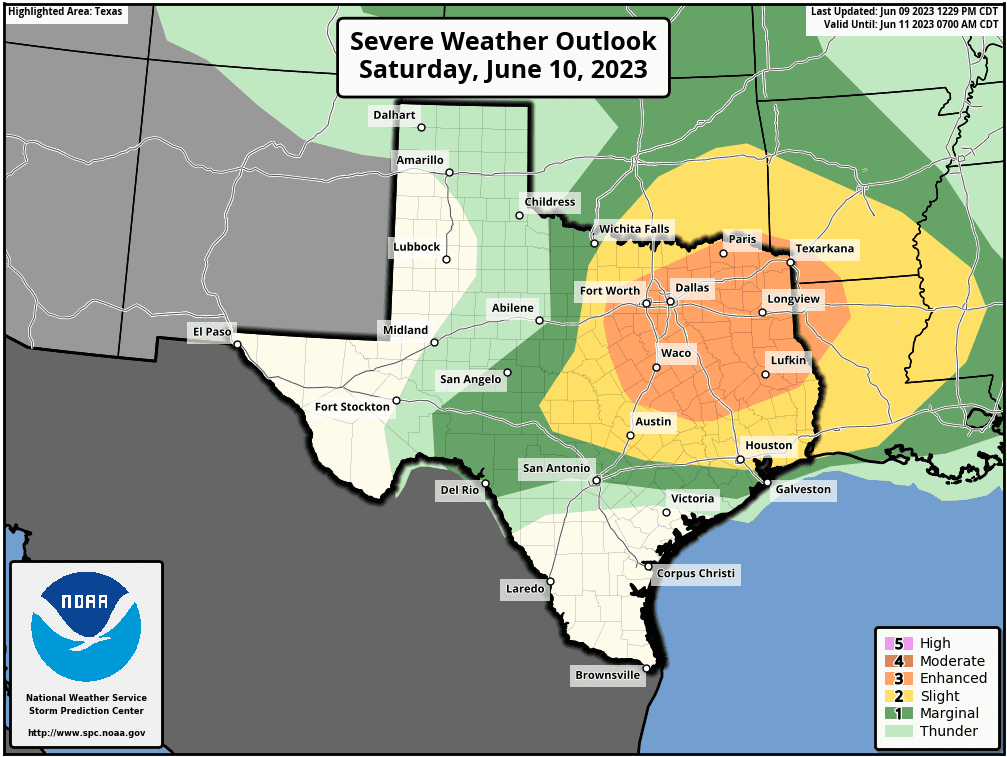
For locations that do see rain and storms, rain amounts should average between a quarter and a half inch, with isolated totals of 1-2 inches possible.
Saturday’s temperature is forecast to be in the mid and upper 90s.
Sunday through Next Friday
Sunny, dry, and very hot weather is forecast across the region as the ridge of high pressure over northern Mexico expands north across Texas. The expanding ridge will likely shut off the periodic waves of low pressure and periods of rain we’ve seen so far this June.
The big news will be the unusually hot temperatures! Much of the Hill Country and Central Texas is expected to see high temperatures close to 100 degrees beginning Sunday, with high temperatures staying close to 100-101 degrees through late week. Thursday and Friday are shaping up to be the hottest days next week, when high temperatures look to rise to around 102-103 degrees. For the coastal plains region, high temperatures throughout the week are forecast to generally be in the upper 90s.
Next Weekend into the Early Part of the Week of June 19th
Unfortunately, little change in the hot and dry weather pattern is forecast. Daily high temperatures are predicted to remain around 100 degrees.
Tropical Weather Outlook
Weather conditions across the Atlantic basin are currently quiet. Tropical storm development is not expected for the next seven days.
Have a good weekend!
Bob
Social Media