Just when it appeared the summer heat dome was beginning to set up for the summer, the heat dome weakened on Sunday. Scattered thunderstorms developed across parts of the Hill Country Sunday afternoon and evening. This was followed by additional thunderstorms across parts of the Hill Country early Monday morning. The storms generally affected the area between Sonora, Junction, and Mason, along with the western half of Blanco County. Rainfall across the area generally averaged between 1 and 1.5 inches. However, two LCRA Hydromet gauges located in Kimble County did pick up higher totals. A gauge located in western Kimble County, along the North Llano River, measured a 24-hour total of 4.34 inches! A second gauge located in southern Kimble County along the South Llano River, recorded 3.71 inches.
A chance for rain has entered the forecast this afternoon and will continue through Wednesday. Monday’s analysis shows the heat dome has weakened and temporarily shifted south into central Mexico. Meanwhile, A weak cold front has moved south out of the Plains states and sagged into North Texas. As of early Monday afternoon, the front stretched from Fort Stockton, to Brownwood, to just south of Dallas. Forecasts call for the cold front to slowly push to the south this afternoon and tonight, stalling somewhere near the Interstate 10 corridor on Tuesday. With the help of a an area of low pressure located over the Panhandle, the cold front is predicted to be the focus for the development of showers and thunderstorms into Wednesday.
For Monday afternoon and Monday night, there will be a 30-40 percent chance for scattered showers and thunderstorms across the region. High resolution forecasts call for an area of thunderstorms to develop across West Texas Monday evening, with some of the storms tracking southeast into parts of the Hill Country and Central Texas late Monday night. Monday’s high temperature is forecast to be in the low and mid-90s.
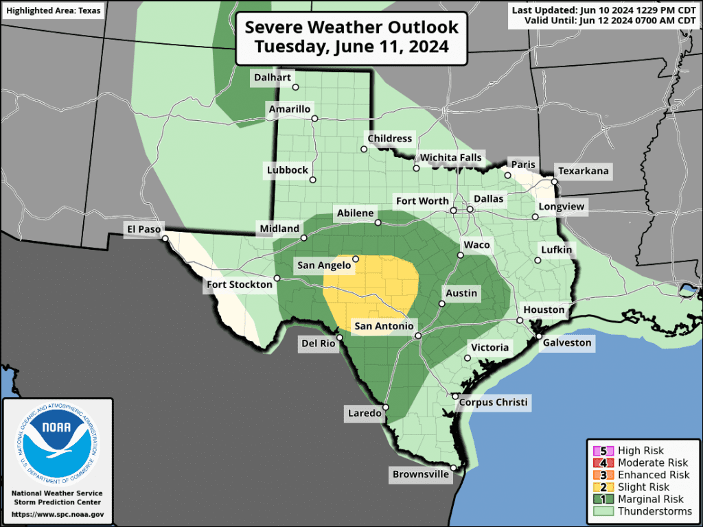
For Tuesday and Tuesday evening, there will be a 40-50 percent chance for scattered rain showers and thunderstorms across the region. Some of the thunderstorms, mainly across the Edwards Plateau and Hill Country regions, may be strong to severe. The Storm Prediction Center has placed this area under a 2 out of 5 risk for severe thunderstorms. A Marginal Risk for severe thunderstorms will extend as far east as Columbus. The primary severe weather risks will be large hail and damaging winds. In addition, a couple of the thunderstorms may be slow-moving, with the potential for locally heavy rain. High temperatures Tuesday are forecast to be in the low 90s.
Tuesday night into Wednesday morning, there will be a continued 40-50 percent chance for rain showers and scattered thunderstorms across the Hill Country and most of Central Texas as the West Texas area of low pressure finally exits to the northeast.
Wednesday afternoon, the chance for rain looks to decrease to 20 percent as the heat dome begins to spread north in the wake of the departing upper trough. High temperatures Wednesday are forecast to be in the low 90s.
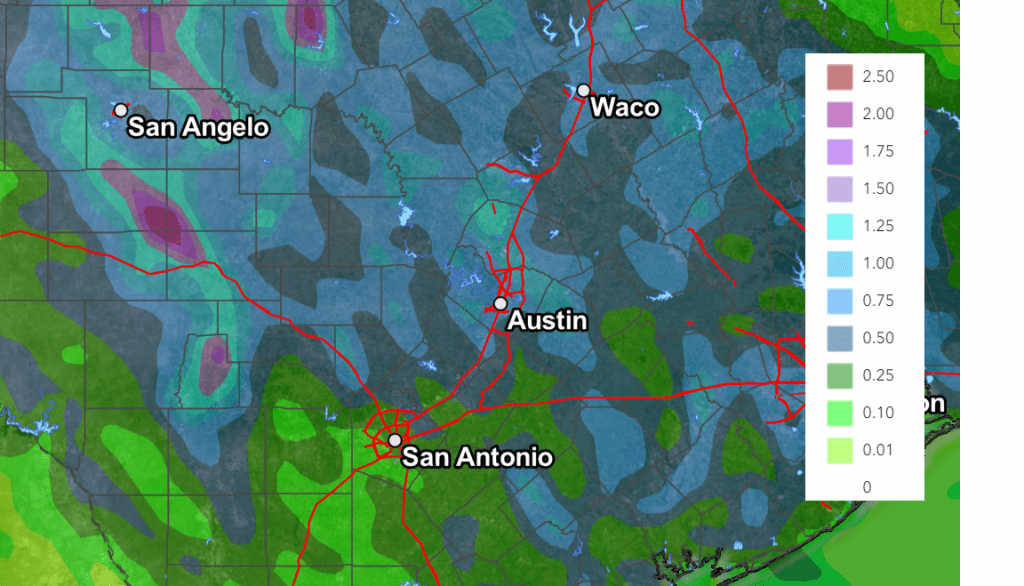
Rain amounts between Monday evening and Wednesday evening are forecast to generally average between 0.5 and 1 inch, with isolated heavier totals possible.
NWS Rainfall Forecast for the Period 7 pm Monday through 7 pm Wednesday:
Mostly sunny, dry, and warmer weather is forecast late week and through the weekend as the heat dome expands north from Mexico, across Texas, and into the Plains states. Warm to hot temperatures are forecast, with daily high temperatures predicted to be in the mid to upper 90s.
Regarding next week’s weather, a plume of deep tropical moisture is currently spreading north out of the western Caribbean Sea into the eastern Gulf of Mexico. This moisture is forecast to be drawn northeastward to Florida over the next 2-3 days. Strengthening high pressure over the southeastern U.S. this weekend is expected to shift the plume of tropical moisture westward toward the central Gulf of Mexico and possibly to the western Gulf by early next week. The forecast solutions are hinting a weak surface low may developing over the central or southern Gulf of Mexico late this weekend or early next week. However, this situation if far from certain. This will be a complex weather pattern, so the forecast solutions are struggling for consistency. If nothing else, some of the tropical moisture shifting westward could spread into parts of Texas next week, possibly bringing our region an increasing chance for rain.
High temperatures next week are forecast to hold mostly in the low and mid-90s.
Tropical Weather Outlook
Weather conditions are currently quiet across the tropical Atlantic and tropical cyclone development is not expected over the next seven days.
Record High Dewpoints in May
If you thought the month of May was unusually humid, you are correct. An analysis by Brian Brettschneider with the National Weather Service (using the ECMWF ERA5 Reanalysis data) shows most of South, Central, North, and East Texas recorded the highest dewpoint temperatures on record for the month of May, dating back to 1940. Combining these record high readings with the very warm temperatures, many locations across Texas also set record heat index values in May.
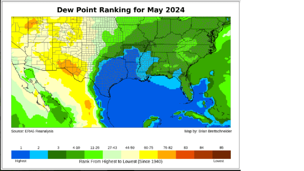
The dewpoint is a measure of how much moisture is in the air. The dew point is defined as the temperature at which water vapor in the air turns into liquid, which would appear as dew on grass or puddles.
Bob
Social Media