There will be a couple of opportunities for thunderstorms across the Hill Country and Central Texas regions this week, but the best chance for a more widespread coverage or rain and storms looks to occur Friday into Saturday morning when a large trough of low pressure and cold front move across the state. Expect warm temperatures all of this week, followed by noticeably cooler readings this weekend and for most of next week. Lows early next week are forecast to fall to the 40s at most locations. Some upper 30s will be possible across the Hill Country.
A weak cold front pushed south through the area Sunday night into Monday morning, bringing a influx of drier and slightly cooler air that will likely extend into Tuesday morning. The front is forecast to move back north as a warm front Tuesday afternoon, bringing a return or warmer and more humid air. Expect light winds Monday, followed by breezy conditions, with gusts to near 30 mph on Tuesday.
- Monday’s high temperature will generally be in the mid and upper 70s across the Hill Country and Central Texas, with mid and upper 80s towards the coast
- Lows Tuesday morning are forecast to be in the low and mid-50s, with low and mid-60s across the coastal plains
- High temperatures Tuesday are predicted to be in the mid-80s
- Lows Wednesday morning will be in the mid and upper 60s, with low 70s expected towards the coast
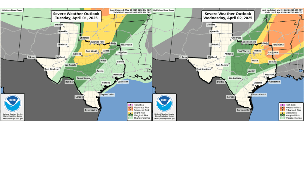
Tuesday night into Wednesday morning, there will be a chance for scattered rain showers and thunderstorms across the Hill Country and the northern half of Central Texas (including the Austin metro area) when a weak cold front sags southeast out of northwest Texas. The probability for rain will range from 40 percent across the northern Hill Country, to just 20 percent in the Austin area. The atmospheric setup near and south of the front appears somewhat favorable for some of the storms to become strong to severe. The Storm Prediction Center has placed the area along and west of a line stretching from just east of Waco, to Austin, to just north of San Antonio under a Marginal Risk, or a1 out of 5 risk, for severe thunderstorms Tuesday evening through 7 am Wednesday. Large hail and damaging winds will be the primary severe weather threats. For areas that happen to see rain, amounts are predicted to average less than a half inch.
A second and somewhat better chance for scattered showers and thunderstorms for the Hill Country and Central Texas regions is forecast to occur Wednesday night into Thursday morning when passing disturbance to our north will help spark the development of scattered showers and thunderstorms along and north of Tuesday’s stalled cold front. Once again, some of the thunderstorms may be strong to severe. The Storm Prediction Center has placed most of the Hill Country and the northern counties of Central Texas under a 1 out of 5 risk for severe thunderstorms through 7 am Thursday. For locations that happen to see rain, totals once again are forecast to average less than a half inch.
High temperatures Wednesday and Thursday are forecast to be warm, with highs in the upper 80s to 90 degrees. Lows Thursday and Friday mornings are predicted to be near 70-72 degrees.
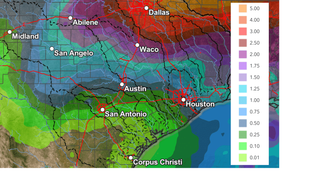
A more widespread coverage of rain showers and thunderstorms is forecast to occur beginning Thursday night, when a large trough of low pressure starts to move to the east out of the western and southwestern U.S., dragging a Pacific cold front into the state. In advance of the front, warm and humid air will spread north from the Gulf. Scattered showers and thunderstorms are forecast to develop Thursday night, then increase in coverage Friday through Friday night. Additional periods of rain are forecast to continue into Saturday morning as the cold front slowly spreads east through the region. The majority of the rain is forecast to taper off from west to east midday Saturday through late Saturday afternoon as drier and a somewhat more stable air spreads in behind the cold front. However, a slight chance for a showers looks to continue Saturday night through midday Sunday as an area of weak atmospheric lift spreads in behind the cold front.
Rain amounts Thursday through Sunday are forecast to range from about 1-1.25 inches across the northern Hill Country, to near 0.5 to 1 inch around the Austin area, to between 0.25 and 0.5 inches across the coastal plains.
NWS Rainfall Forecast for Valid through 7 pm next Monday:
Cooler air will spread south across the area Saturday afternoon and Saturday night behind the cold front and remain in place through the middle of next week. Sunny and dry weather is forecast next Monday through Friday as weak ridge of high pressure sets up over the south central U.S.
- Lows Sunday morning are forecast to be in the mid-40s across the Hill Country, the upper 40s across Central Texas, with upper 50s near the coast
- High temperatures Sunday are predicted to be in the low 60s across the Hill Country and Central Texas regions, and in the upper 60s across the coastal plains
- Lows next Monday morning will include the low 40s across the Hill Country, the mid-40s across Central Texas, and upper 40s across the coastal plains
High temperatures Monday through Wednesday are forecast to be in the 70s. Lows Tuesday and Wednesday mornings will be in the 40s. Warmer temperatures will return next Thursday and Friday with highs returning to the 80s, with lows in the 50s.
Bob
Social Media