A Chance for Severe Thunderstorms Tuesday and Again on Wednesday
April 24, 2023
This week’s weather highlight will be the potential for strong to severe thunderstorms on Tuesday, followed by another possible round of severe thunderstorms on Wednesday. All forms of severe weather will be possible from both rounds of storms. Totals from the rain and thunderstorms are not forecast to be all that heavy, with 2-day totals averaging around a half inch. However, isolated totals of 1-2 inches will be possible. Another highlight to this week’s weather will be the continued mild temperatures, with highs remaining in the 70s to low 80s.
On Saturday, an area of strong to severe thunderstorms tracked southeast across parts of the Hill Country, producing areas of very large hail and pockets of heavy rain. Totals of 1-1.5 inches were recorded across parts of Mason and Gillespie Counties, as well as Brown and Coleman Counties. The rain and thunderstorm activity shifted to South Texas and the middle Texas coast late Saturday night into Sunday morning. These storms produced totals mainly in the range of 0.5 to 1 inch.
Here’s a breakdown of this week’s weather:
Monday Afternoon through Monday Night
In the wake of Sunday’s storms, a dry and quiet pattern is in currently in place across the region. Expect a partly to mostly cloudy sky this afternoon, with high temperatures in the mid and upper 60s.
A slight chance for drizzle and rain showers will develop after midnight Monday night as a warm front begins lifting north from the coast. This should allow very moist air to spread inland. Lows Tuesday morning will be in the mid and upper 50s.
Tuesday through Tuesday Night
Tuesday afternoon into Tuesday evening is shaping up to be our region’s next period of active weather.
Scattered rain showers are predicted to increase in areal coverage Tuesday morning as moisture levels increase further. A chance for showers and scattered strong to severe thunderstorms is forecast to develop Tuesday afternoon as atmospheric lift increases in advance of a trough of low pressure tracking southeast out of the southern Rockies. Although a weak cap, or stable layer in the middle atmosphere will be in place initially, this cap is predicted to eventually erode, enabling thunderstorms to rapidly develop. Atmospheric conditions are predicted to be structured in a way that will support the development of some supercell thunderstorms. These storms will be capable of producing large hail, damaging downburst winds, and also some scattered tornadoes.
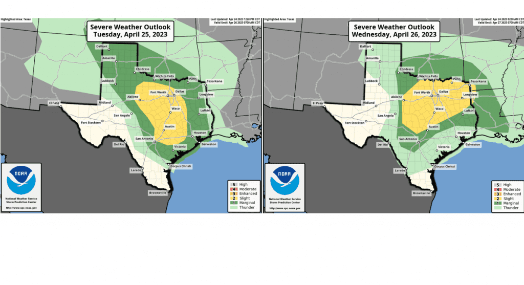
The Storm Prediction is pinpointing the eastern Hill Country and all of Central Texas, including the Austin metro, for the greatest threat for severe storms. SPC has placed this area under a Slight Risk, or 2 out of 5 risk, for severe thunderstorms. A Marginal Risk, or 1 out of 5 risk, is noted for the central Hill Country and the middle Texas coast.
The chance for showers and thunderstorms is forecast to decrease by midnight Tuesday night as the trough of low pressure moves off to the northeast. Rain amounts Tuesday through Tuesday evening are forecast to average around a quarter inch, with isolated totals of 1-1.25 inches possible.
High temperatures Tuesday are forecast to be in the mid-70s. Lows Wednesday morning will be in the mid-60s.
Wednesday through Thursday
Wednesday is forecast to start of cloudy. The focus for rain and thunderstorm activity is expected to occur Wednesday afternoon through Wednesday night as a cold front pushes southeast out of Northwest Texas. Atmospheric conditions ahead of the cold front are expected to become quite moist and unstable through the afternoon. This will lead to the possible development of strong to severe thunderstorms ahead of and along the cold front. As of now, the Storm Prediction Center has pinpointed the northern Hill Country and all of North Texas, extending south to near Austin as having the highest potential for severe storms. SPC has placed this area under a Slight Risk, or a 2 out of 5 risk. A Marginal Risk, or 1 out of 5 risk covers the rest of the Hill Country and Central Texas as far south as Smithville. Severe weather threats will include large hail, damaging downburst winds and isolated tornadoes.
Rain amounts of 0.25 to 0.5 inches are forecast across the eastern Hill Country and most of Central Texas. Lower totals are forecast across the middle Texas coast.
The chance for rain is forecast to diminish from northwest to southeast Thursday morning as drier air spreads in behind the cold front. Clouds will decrease with the sky becoming sunny Thursday afternoon.
- High temperatures Wednesday are forecast to be around 80-82 degrees.
- Lows Thursday morning are forecast to be in the mid-50s to low 60s.
- High temperatures Thursday are predicted to be in the mid-70s.
- Lows Friday morning will be in the low and mid-50s.
Friday through Friday Night
Friday’s weather is shaping up to be sunny and warm, with high temperatures in the low and mid-80s.
A fairly strong cold front is forecast to sweep southeast across the region Friday evening into Friday night, bringing cooler air. No rain is expected with the cold front.
Lows Saturday morning will range from the low 50s across the Hill Country, to the upper 50s near the coast.
Saturday through Sunday
Sunny and dry weather is forecast through the weekend as a ridge of high pressure strengthens over the south central U.S.
- High temperatures Saturday are forecast to be in the low 70s, warming to the upper 70s on Sunday.
- Lows Sunday morning will be in the upper 40s to low 50s.
Next Week
Mostly sunny and dry weather is forecast next Monday through Wednesday as the ridge of high pressure remains over the area. Expect high temperatures in the low 80s, with low temperatures in the low 60s.
The next chance for rain is forecast to develop Thursday into Friday as the ridge moves off to the east, and a southwesterly flow in the upper atmosphere begins to pull atmospheric disturbances into Texas out of the eastern Pacific. High temperatures will continue in the low to mid-80s, with lows in the 60s.
Have a good week.
Bob
Social Media