Quiet weather conditions are currently in place and are forecast to continue through Wednesday night. Moisture returning off the Gulf of Mexico will cause the development of widespread low clouds Tuesday night through Wednesday morning. A mostly cloudy to partly cloudy sky is forecast Wednesday afternoon and Wednesday night.
The temperature will be trending milder.
- Lows Wednesday morning are forecast to be in the upper 40s to low 50s.
- High temperatures Wednesday are forecast to be near 68-70 degrees.
- Low temperatures Thursday morning are forecast to be in the upper 50s.
Thursday morning through Sunday night, daily rain chances will enter the weather outlook. This wet and unsettled pattern will be the result of a large trough of low pressure moving inland along the southern coast of California Thursday and its slow track to the east. Multiple disturbances are forecast to track across Texas out ahead of the trough resulting in the development of scattered rain showers and isolated thunderstorms beginning Thursday morning.
Thursday’s weather will feature a cloudy sky with patchy fog and drizzle through the morning hours, followed by a 30-40 percent chance for scattered rain showers Thursday afternoon. The probability for rain showers and isolated thunderstorms will increase to 50 percent Thursday night through Friday afternoon. Rain amounts Thursday through Friday afternoon are predicted to generally be between 0.25 and 0.50 inches.
The chance for rain looks to temporarily taper off from west to east Friday evening through Saturday morning.
Rain showers and scattered thunderstorms are forecast to develop and increase in areal coverage across the region Saturday afternoon and Saturday evening and continue throughout the day Sunday as the western trough moves from southern New Mexico to the southern Plains states. The trough will help push a Pacific cold front across the area Sunday afternoon. The probability for rain will be near 40 percent Saturday and at 60 percent Saturday night and Sunday. Most of the rain is predicted to taper off from west to east Sunday night as drier air spreads in behind the cold front.
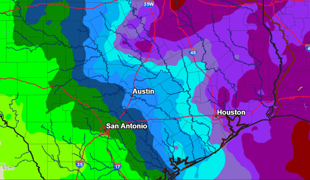
Rain amounts Sunday through Sunday night are forecast to average around a quarter inch or less across the Hill Country, be between a quarter and a half inch across Central Texas, and be between a half inch and one inch across the coastal plains.
Christmas Day Weather is shaping up to be mostly cloudy. There will be a slight chance for a few light rain showers throughout the day, but rain amounts look to remain below a tenth of an inch.
Total rain amounts over the upcoming period are forecast to be lowest across the Hill Country and heaviest across the coastal plains and Southeast Texas. Totals will range from 0.25 to 0.75 inches across the Hill Country, to around 1.25 inches across the coastal plains.
NWS Rainfall Forecast Valid through 6 pm Tuesday, 12/27
Temperatures are forecast to be quite mild Thursday through Sunday, with highs in the low 70s and lows in the upper 50s to low 60s. Cooler air is forecast to spread into the area Sunday night. Low temperatures Christmas morning are forecast to be in the upper 40s to low 50s. High temperatures Christmas Day are predicted to be in the mid-60s.
No arctic air is on the horizon through the end of the year.
Bob
Social Media