As we start off the month November, I’m happy to say we’re entering a weather pattern that looks to bring our region cooler/less hot temperatures along with some chances for rain. The broad ridge of high pressure which has dominated our region’s weather all of October has finally shifted to the east. This change will enable a series of low pressure troughs and cold fronts to spread across Texas over the next week, bringing chances for rain and cooler temperatures.
Friday’s weather will feature a mostly cloudy sky across the region. The cold front which pushed south through the area Thursday is quickly returning north as a warm front, bringing a surge of low-level moisture. Although plenty of moisture will be in place, Friday’s atmosphere is lacking a significant trigger for rain. As a result, there will be just a 20 percent chance for a few passing showers across the Hill Country and Central Texas regions through Friday night. Significant rain is not expected. For locations south of Interstate 10, the chance for scattered rain showers and thunderstorms will be near 40 percent Friday afternoon, decreasing to 20 percent Friday night. Rain amounts should average less than a quarter inch. Friday’s high temperature will range from the upper 70s across the northern Hill Country, to the mid-80s across the coastal plains.
This weekend and into Monday, there will be a slight chance for scattered rain showers and isolated thunderstorms across the region as a large trough of low pressure sinks south from the northern Rockies into the Desert Southwest. East of the trough, a series of compact disturbances are predicted to track from west to east across the northern half of Texas. These disturbances look to help spark the development of scattered showers and thunderstorms. The probability for rain is forecast to be near 30 percent Saturday through Monday afternoon. Rain amounts through late Monday are predicted to average close to a quarter inch. A few isolated heavier totals will be possible.
Expect a mostly cloudy to partly cloudy sky through the period. Breezy southerly winds of 10-20 mph, with gusts to near 25/30 mph will be also be in place. Daily high temperatures are predicted to generally be in the mid to upper 80s.
The biggest change in the weather and the best chance for rain and thunderstorms is expected to occur Monday night into Tuesday morning when the trough out west lifts to the north, allowing a Canadian cold front to sweep south through Texas. Forecasts call for the cold front to reach the northern Hill Country late Monday evening, the Austin area in the hours after midnight, and the coastal region around sunrise on Tuesday. Forecasts call for a large area rain showers and thunderstorms to develop along and behind the cold front when it moves across our region. There will be a small potential for some of the thunderstorms to be strong to possibly severe mainly—mainly for areas along and to the east of Interstate 35.
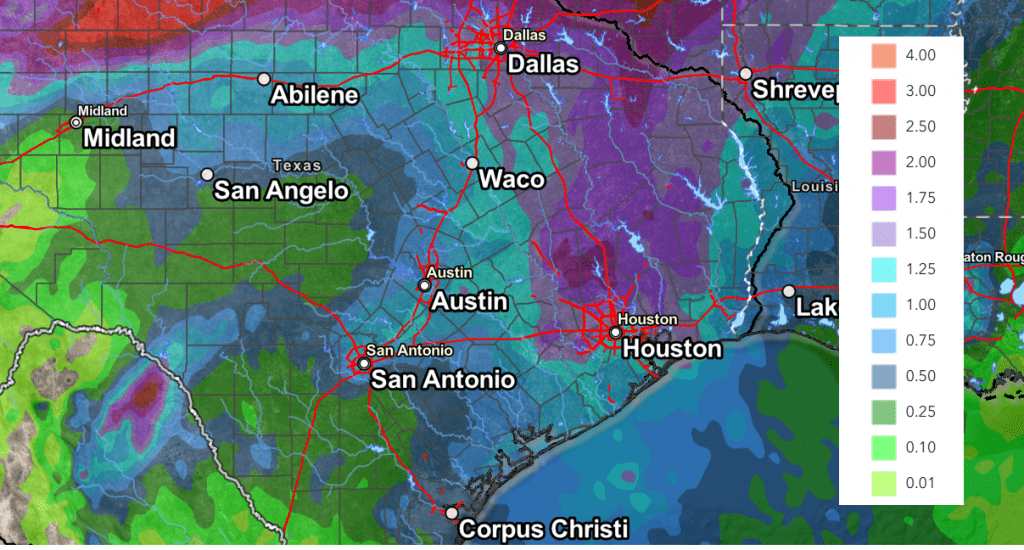
The rain is forecast to taper off across the Hill Country and Central Texas regions before sunrise Tuesday, and across the coastal plains, by mid-morning. Rain amounts from the line of showers and thunderstorms is forecast to average between 0.25 and 0.75 inches across the Hill Country, and between 0.75 and 1.25 inches across Central Texas and the middle Texas coast.
NWS Rainfall Forecast for the Period 7 pm Friday through 6 pm Wednesday:

Noticeably cooler air will follow Monday night’s cold front, and this cool air is forecast to remain in place through late next week and next weekend. Expect a mostly sunny sky Tuesday and Wednesday.
- Daily high temperatures Tuesday through Friday will range from the upper 60s to low 70s across the Hill Country, to the upper 70s across the coastal plains
- Lows will range from the mid and upper 40s across the Hill Country, to the upper 50s and low 60s across the coastal plains
Longer-range forecasts call for a chance for rain to return to the forecast late next week as another trough of low pressure lifts northeast out of the Desert Southwest. Rain amounts from this system are not expected to be very heavy.
Tropical Weather Update
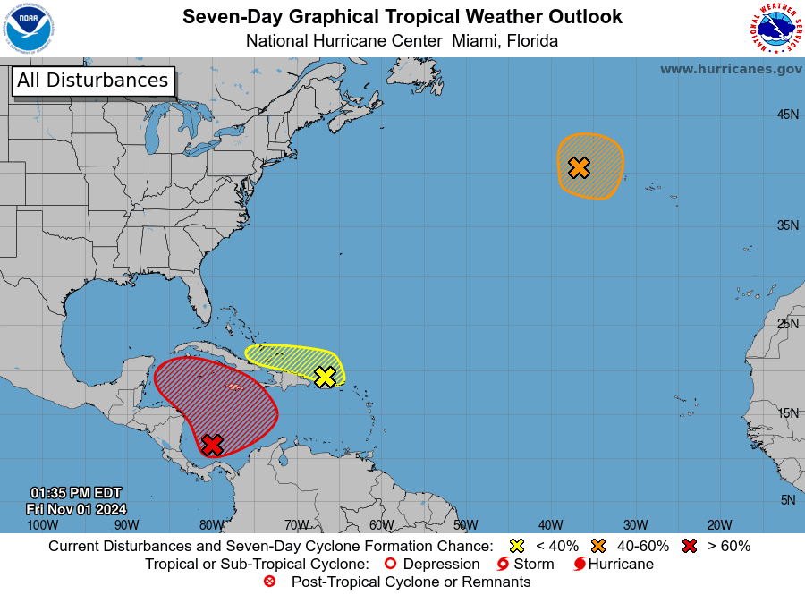
National Hurricane Center forecasters continue to monitor a broad area of low pressure over the southwestern Caribbean Sea. NHC forecasters indicate an area of low pressure is likely to form over this area in a couple of days. Gradual development will be possible thereafter, and a tropical depression could form over the weekend or early next week. The system is forecast to drift generally northward over the central or western Caribbean Sea.
NHC forecasters are giving this system a 70 percent chance for tropical development over the next seven days.
Ensemble forecast solutions are split on where this system will track. Some solutions show the system heading west to Mexico in another week, while others show the system coming north toward Florida. It’s too early to have much confidence in either solution. With next week’s cold front moving into the Gulf of Mexico, there is very little chance this system could move toward Texas and the western Gulf.

NHC forecasters note a separate trough of low pressure located near Puerto Rico is producing a large area of showers and thunderstorms over portions of the Greater Antilles and the adjacent waters of the Atlantic and the northeastern Caribbean. Slow development of this system will be possible during the next few days as it moves west-northwestward near the Greater Antilles. After that time, this system is expected to be absorbed into the low pressure area over the Caribbean.
NHC forecasters are giving this system only a ten percent chance for tropical development over the next seven days.
Time Change Weekend
This is time change weekend. Daylight Saving Time will come to an end this Sunday morning, November 3rd, at 2 am. At that time, we will move to standard time. Remember to “fall back” and set clocks back one hour before going to bed Saturday night.
Have a great weekend!
Bob


Social Media