Friday started off rather chilly. LCRA’s Hydromet showed temperatures reached the mid-30s to low 40s across the Hill Country and Central Texas regions and the mid to upper 40s across the middle Texas coast. It’s interesting to note that many traditional low spots, including Austin-Bergstrom International Airport, recorded low temperatures in the upper 20s to low 30s. ABIA recorded a low of 32 degrees, while Austin-Camp Mabry recorded a low of 44 degrees.
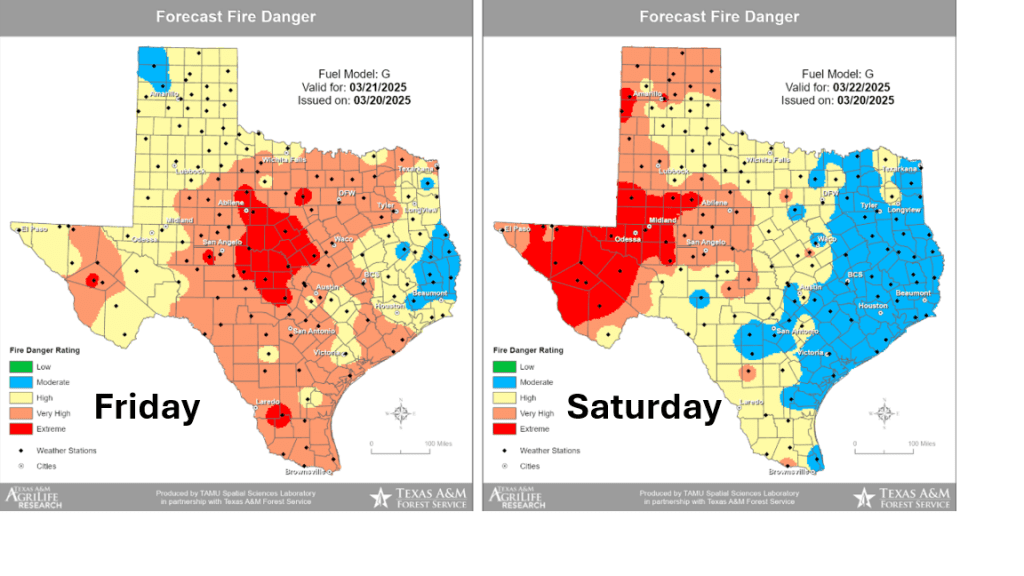
The area of high pressure which brought the cool air into our region has moved off to the east, causing the return of southerly breezes. Wind speeds are predicted to increase to a range of 10-20 mph, with occasional gusts to 30 mph Friday afternoon into Friday evening as the pressure gradient strengthens. The air mass is currently quite dry across as low-level moisture will take some time to return off the Gulf. Minimum relative humidity levels are forecast to reach the teens to low 20 percent range Friday afternoon. The combination of the strong winds, low humidity levels, and dry vegetation is expected to cause elevated to near critical fire weather conditions across the entire region Friday afternoon. Any fires that happen to develop will spread quickly. All types of outdoor burning are not recommended!
Sunny and warmer weather is forecast Friday afternoon through Saturday. Wind speeds are predicted to decrease to 5-10 mph Friday night, but increase to 10-15 mph with gusts to 25 mph Saturday. Meanwhile, relative humidity levels are forecast to be higher Friday night through Saturday as low-level moisture slowly returns off the Gulf. The higher relative humidity levels should cause fire weather conditions to improve some on Saturday.
Fire Danger Forecast for Friday and Saturday (Texas A&M Forest Service):
- High temperatures Friday are forecast to be in the mid and upper 70s
- Lows Saturday morning will generally be in the low 50s
- High temperatures Saturday are predicted to be in the low and mid-80s
- Lows Sunday morning are forecast to be in the low and mid-60s
- High temperatures Sunday are forecast to be in the mid-80s
A trough of low pressure moving east across the Plains on Sunday will help to a Pacific cold front across the Hill Country and Central Texas regions late Sunday afternoon into Sunday evening. The front is forecast move across the coastal plains region after midnight Sunday night. Ahead of the cold front, low-level moisture is expected to spread north from the Gulf, causing a partly cloudy sky. Forecasts indicate a few rain showers and isolated thunderstorms may accompany the cold front when it moves across the area Sunday evening and Sunday night. The probability for rain will be near 30-40 percent. Low rain amounts are forecast, with most totals averaging around a tenth of an inch or less.
NWS Rainfall Forecast for the Period 7 am Friday through 7 am Monday:

Quiet and warm weather is forecast for the first half of next week as a weak ridge of high pressure spreads over Texas. High temperatures Monday are forecast to be in the mid-80s. Highs Tuesday are forecast to be in the upper 80s to low 90s. Highs Wednesday are forecast to be in the mid and upper 80s.
Forecasts call for a temporary change in the persistent dry weather pattern late next week when a trough of low pressure is predicted to slowly track from northern Mexico eastward across Central and South Texas. This system is expected to pull considerable moisture north from the Gulf of Mexico and cause the development of widespread rain showers and scattered thunderstorms across a large part of Texas beginning Wednesday night, continuing Thursday through Friday. This will be very beneficial rain! National Weather Service rainfall forecasts are showing the potential for totals between 1 and 2 inches across Central and South Texas next Thursday through Friday. Cumulative totals of more than 2 inches will be possible over parts of the Hill Country and the Edwards Plateau.
NWS Rainfall Forecast for the Period 7 pm Wednesday through 7 pm Friday:

Dry and warm weather is forecast next weekend, continuing into the start of April.
Have a great weekend!
Bob
Social Media