The long holiday weekend featured dry weather and pleasant, fall-like temperatures. Many parts of the Hill Country recorded readings at or below freezing Thursday and Friday mornings. The temperature stayed above freezing at most other locations. In Austin, Camp-Mabry’s lowest temperature occurred Friday morning with 39 degrees. Austin-Bergstrom’s lowest temperature also occurred Friday morning, with 37 degrees.
Weather conditions are quiet as we kick off this first week of December. Monday’s weather maps showed a weak cold front situated along the Red River that is dropping to the south. This front is forecast to quietly push south across Texas this Monday afternoon and Monday night, causing the wind to shift back out of the north Monday night into Tuesday. A sunny sky is forecast Monday afternoon, followed by a partly cloudy sky Monday night.
- High temperatures Monday are forecast to generally be around 68-70 degrees
- Lows Tuesday morning will include the upper 30s to low 40s across the Hill Country, the low and mid-40s across Central Texas, and the upper 40s across the coastal plains.
Clouds are forecast to increase across the area Tuesday in response to weak trough of low pressure tracking to the east out of the Desert Southwest. Clouds and moisture look to begin spreading north from the Gulf of Mexico in advance of the approaching trough of low pressure. As moisture levels increase, a slight chance for light rain showers is forecast to develop across the region after midnight Tuesday night. A somewhat better chance for occasional rain showers (40-50 percent) is forecast for the Hill Country and Central Texas regions Wednesday morning, continuing through Wednesday afternoon. Just a slight chance for rain is forecast Wednesday night. Rain amounts through early Thursday morning are forecast to average less than a tenth of an inch across the Hill Country, and less than a quarter inch across Central Texas.
The approaching upper trough is forecast to bring a better chance for rain showers to the coastal plains region beginning late Tuesday night, continuing through Wednesday night. Here, the chance for rain will be near 70 percent. Rain amounts through early Thursday morning are forecast to generally average between 0.5 and 1 inch, with isolated heavier totals.
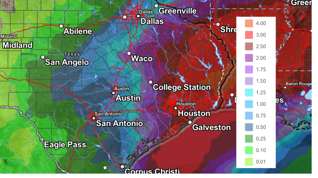
NWS Rainfall Forecast for the Period 6 pm Monday through 6 pm Thursday:

- High temperatures Tuesday and Wednesday are forecast to be in the mid-60s across the Hill Country and Central Texas regions, and in the upper 60s to low 70s across the coastal plains
- Lows Wednesday and Thursday mornings are forecast to be in the mid-50s
For Thursday, expect a mostly cloudy sky across the region. No rain is forecast across the Hill Country and Central Texas regions. Meanwhile, a slight chance for rain is forecast to continue across the coastal plains. Expect high temperatures in the upper 60s to 70 degrees.
Forecasts call for a cold front to spread south across the area Thursday afternoon into Thursday night, bringing a shot of slightly cooler air for Thursday night and Friday. At the same time, a second trough of low pressure is forecast to set up over the Desert Southwest. This system is predicted to slowly track to the east, moving across Texas this weekend. The advancing trough is expected to cause overrunning clouds and bring a chance for rain showers to the region Friday through Sunday, with the best chance rain expected to occur Saturday and Saturday night. Rain amounts Friday through Monday morning are forecast to average around a half inch across the Hill Country, between 0.5 and 0.75 inches across Central Texas, and 0.5 and 1 inch across the coastal plains region.
Adding in the forecasted rain from the first half of the week with the forecasted rain late week and over the weekend, the National Weather Service’s rainfall forecast valid through 7 pm Monday calls for totals of 0.5 to 0.75 inches across the Hill Country, 0.5 to 1 inch across Central Texas, and 1-2 inches across the coastal plains.
NWS Rainfall Forecast Valid through 6 pm Monday, 12/9

High temperatures Friday through Sunday are forecast to be in the low and mid-60s. Lows Saturday through Monday morning are forecast to be in the low and mid-40s, with low 50s across the coastal plains.
Looking ahead to next week, forecasts call for partly cloudy and dry weather Monday and Tuesday. A chance for rain showers looks to develop next Wednesday into Thursday as another trough of low pressure moves over the area out the Desert Southwest. As of now, rain amounts are not expected to be very heavy with this next system. High temperatures next week are predicted to be in the 60s to low 70s, with lows in the 40s.
No outbreaks of unusually cold weather are predicted over the next couple of weeks.
Tropical Weather Update
The 2024 Atlantic hurricane season ended November 30th. Weather conditions across the tropical Atlantic are quiet as atmospheric conditions are becoming quite unfavorable for tropical development.
November Climate
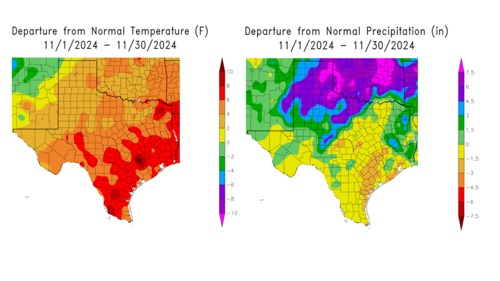
The month of November featured drier than normal, and much warmer than normal temperatures across the entire region.
Rainfall generally averaged around an inch below normal across the Hill Country and the Austin/Interstate 35 corridor. Rainfall averaged between 1 and 3 inches below normal for areas southeast of Austin.
November’s temperature averaged between 4 and 8 degrees above normal across the entire region. November will likely rank as one of the warmest on record.
For Austin-Camp Mabry, November 2024 ranked as the 4th warmest and the 70th driest/55th wettest November on record.

Bob


Social Media