A Chance for Rain Developing Late Week, With Another Chance for Rain Expected Next Week
July 15, 2024
Dry and quiet weather conditions are in place as we kick off the new week. The area of low pressure over northern Mexico responsible for the clouds and scattered showers across the region over the weekend has shifted to the south, taking the clouds and most of the moisture with it. Meanwhile, the heat dome which has recently been parked over the western U.S. has nudged itself a little further to the east to now cover much of Texas. The heat dome is expected to cause a pattern of generally sunny, dry, and hot weather this afternoon through Wednesday.
The only exception to this will be for areas located to the south of Interstate 10, where lingering moisture and an active sea breeze front will cause a 20 percent chance for scattered afternoon rain showers and isolated thunderstorms this afternoon through Wednesday. Rain amounts should stay below a quarter inch.
- High temperatures Monday afternoon through Wednesday are forecast to be near 98-100 degrees across the Hill Country and Central Texas regions, and in the low to mid-90s across the coastal region.
A trend toward a less stable weather pattern is forecast for Thursday and Friday as the heat dome shifts more to the west and a large trough of low pressure develops from the Great Lakes, south to the southern Plains. This will allow a rare July cold front to push south into Texas late week, increasing the chance for rain. The front is forecast to reach the Central Texas region late Thursday, then stall somewhere close to Interstate 10 Friday into Saturday. Outflow boundaries from storms over North Texas will help to increase the chance for rain and scattered thunderstorms across the region beginning Thursday afternoon, with another chance for rain expected on Friday. The probability for rain both days is forecast to be near 40-50 percent. Rain amounts Thursday through Friday are predicted to average less than a quarter inch across the Hill Country, average less than a half inch across Central Texas and the coastal plains. High temperatures Thursday and Friday are forecast to be in the mid-90s.
The outlook for the weekend calls for just a slight chance for rain across the region on Saturday, followed by a better probability for rain on Sunday as the trough over the southern Plains sharpens, pulling more moisture north from the Gulf. Sunday’s totals are forecast to generally average between 0.5 and 1 inch. Weekend high temperatures are forecast to be in the low and mid-90s.
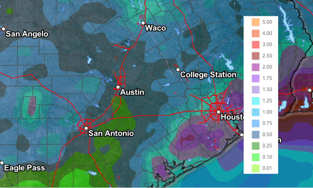
Looking ahead to next week, forecasts are pointing to an unsettled weather pattern across the region, with continued chances for rain through late week as the trough of low pressure remains stationary over the southern Plains and northern Texas. Elevated chances for widespread showers and scattered thunderstorms are forecast Monday through Friday. It’s interesting to note both the GFS and ECWMF ensemble solutions call for totals through Friday of 1-2 inches, and possibly higher. There are still many details to be worked out, but it is looking to be wet and unsettled next week.
NWS Rainfall Forecast Valid through 7 am Next Monday:
Temperatures next week are not predicted to be all that hot, with highs mostly in the low 90s.
Tropical Weather Outlook
Weather conditions remain quiet across the tropical Atlantic as a large area of Saharan dust spreads to the west. There are no systems in place which pose a threat for tropical development for the next seven days.
Have a good week!
Bob
Social Media