A Chance for Rain Developing for all of Next Week
OCT. 20, 2023
The weather has been very fall-like this week, featuring chilly/cool nights and mild afternoons. And just when it seemed like fall had finally arrived, summer-like temperatures in the 90s are forecast to make a return today and through the weekend. Fortunately, these 90s are not expected to hang around for very long.
A dry weather pattern continue across the region thanks to a large ridge of high pressure parked across northern Mexico and the Southwestern U.S. The ridge is forecast to remain over the area through the weekend, causing continued dry weather. Forecasters are monitoring the progress of eastern Pacific Hurricane Norma, currently located about 250 miles south of Cabo San Lucas. Norma is predicted to move inland along the west coast of Mexico, just east of Baja, California on Sunday. Clouds and high-level moisture from the weakening system are forecast to spread over Central Texas late Sunday into Monday. Note the remnants of Norma are forecast to spread northeast across northern Mexico and the Desert Southwest early next week, staying well to the northwest of our region.

NOAA/Colorado State University/RAMMB 10/20/2023 1:30 pm CDT
A Pacific cold front quietly moved across the Hill Country and Central Texas regions late Thursday, bringing drier air and turning surface winds out of the west. The combination of the westerly down sloping winds, dry air, and full sunshine is expected to help push Friday’s temperature into the mid-90s, with low 90s expected towards the coast. Despite the warm afternoon readings, the dry air will allow temperatures to cool down nicely Friday night. Lows Saturday morning will generally be near 58-60 degrees.
Fairly similar weather conditions are forecast across the area Saturday. Although we’ll likely see some scattered high clouds, high temperatures are predicted to again be in the low and mid-90s. Lows Sunday morning will be in the mid-60s.
Sunday’s weather will feature a partly cloudy sky as considerable mid and high-level clouds spread over the area from the southwest. High temperatures look to be a little lower, mainly in the upper 80s. Lows Monday morning are forecast to be in the upper 60s.
Monday’s weather will feature a mostly cloudy sky along with a few scattered light rain showers in the afternoon. Rain amounts are forecast to average less than a tenth of an inch. Expect a high temperature in the mid-80s.
Changes in the weather pattern will begin to take place across our region next Tuesday when a large trough of low pressure sinks south along the West Coast, and southerly breezes increase off the Gulf of Mexico. Forecasts call for the trough to reach northwestern Mexico and southern Arizona next Tuesday, then slow down and become nearly stationary Wednesday through Friday. The trough is predicted to finally lift northeast into the southern Plains late next week into next weekend. With the trough stalled across northwestern Mexico next week, occasional disturbances are predicted to track east of the trough and move across Texas. These disturbances, combined with abundant moisture off the Gulf of Mexico, are expected to cause daily periods of rain showers and thunderstorms.
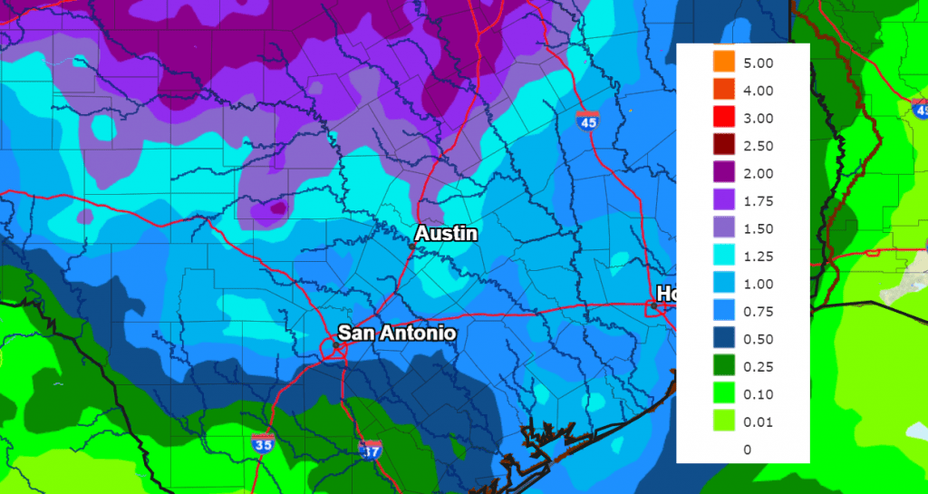
While the heaviest and most widespread rain is forecast to occur across Northwest and North Texas, including the Big Country, we will also see a good chance for rain showers and scattered thunderstorms across the Hill Country, Central Texas, and coastal regions. Daily rain amounts of 0.25 to 0.5 inches are forecast for the Hill Country and most of Central Texas. Slightly lower totals are forecast across the coastal plains. The National Weather Service’s rainfall forecast through next Friday evening calls for widespread totals of 1-1.5 inches across the Hill Country, Central Texas, and coastal regions. Totals close to 2 inches are forecast for the the northern Hill Country.
NWS Rainfall Forecast for the Period 7 pm Friday through 7 pm next Friday:
Southerly flow off the Gulf of Mexico will bring warm and humid conditions to the area for all of next week. Expect daily high temperatures in the mid-80s, with lows around 68-72 degrees.
A Canadian cold front is forecast to move across the area next Saturday, clearing out the clouds and rain, and bringing cooler temperatures. Highs next weekend are forecast to be in the 70s, with lows in the 50s.
Tropical Weather Outlook
Weather conditions are quiet across the Gulf of Mexico. Tropical cyclone development is not expected here over the next seven days.
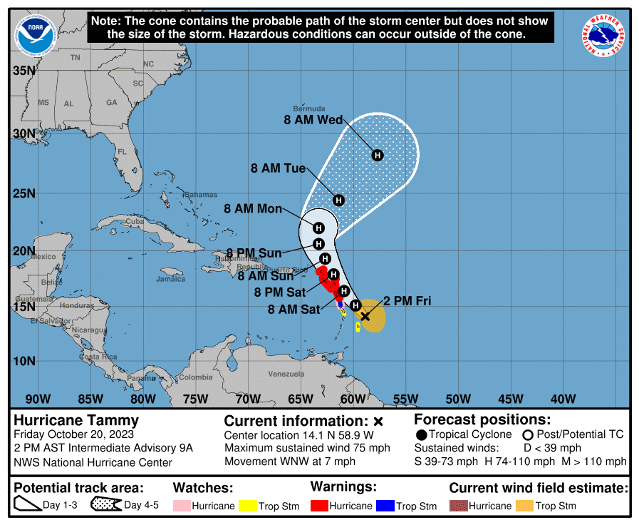
The National Hurricane Center is closely monitoring Hurricane Tammy, located just east of the Lesser Antilles. Data from NOAA and Air Force Reserve reconnaissance aircraft indicate that the maximum sustained winds are near 75 Gradual strengthening is forecast during the next couple of days, and Tammy is expected to remain a hurricane while it moves near or over portions of the Leeward Islands. On the forecast track, the center of Tammy will move near or over portions of the Leeward Islands tonight and on Saturday, and then move north of the northern Leeward Islands on Sunday.
2023’s Orionid Meteor Shower will Peak this Weekend
The Orionid meteors associate with the current shower come from Halley’s Comet. This comet orbits the sun every 76 years or so, with dust particles being expelled from the comet’s nucleus and left behind in its path. We intercept this path in late October each year. The Orionids produced from Halley’s Comet’s particles occur on its inbound leg into our solar system. They are moving in one direction, we are moving in nearly the opposite direction, and the combined speeds produce fast-moving meteors. Note the Orionids aren’t the year’s strongest shower of the year. From a dark location you might see 10 to 20 Orionids per hour at their peak. However, there’s always the element of uncertainty and possible surprise when it comes to meteor showers.
When to watch: Watch for Orionid meteors on both the morning of October 21 and the morning of 22, after midnight and in the wee hours before dawn.
Radiant: The radiant rises before midnight and is highest in the sky around 2 a.m.
Nearest moon phase: At the Orionids’ peak, the moon will be setting around midnight and will not interfere with the meteor shower.
These fast-moving meteors occasionally leave persistent trains. The Orionids sometimes produce bright fireballs.
Bob
Social Media