Forecast for Central Texas

 0%0%
0%0% 70%
70% 70%
70% 0%
0%
Reports from LCRA’s Hydromet
Rainfall summaryTemperature summary
Humidity summary
Bob's Blog on Central Texas Weather
A Chance for Showers Late Week and through the Weekend
There will be a couple of opportunities for thunderstorms across the Hill Country and Central Texas regions this week, but the best chance for a more widespread coverage or rain and storms looks to occur Friday into Saturday morning when a large trough of low pressure and cold front move across the state. Expect warm temperatures all of this week, followed by noticeably cooler readings this weekend and for most of next week. Lows early next week are forecast to fall to the 40s at most locations. Some upper 30s will be possible across the Hill Country.
A weak cold front pushed south through the area Sunday night into Monday morning, bringing a influx of drier and slightly cooler air that will likely extend into Tuesday morning. The front is forecast to move back north as a warm front Tuesday afternoon, bringing a return or warmer and more humid air. Expect light winds Monday, followed by breezy conditions, with gusts to near 30 mph on Tuesday.
- Monday’s high temperature will generally be in the mid and upper 70s across the Hill Country and Central Texas, with mid and upper 80s towards the coast
- Lows Tuesday morning are forecast to be in the low and mid-50s, with low and mid-60s across the coastal plains
- High temperatures Tuesday are predicted to be in the mid-80s
- Lows Wednesday morning will be in the mid and upper 60s, with low 70s expected towards the coast
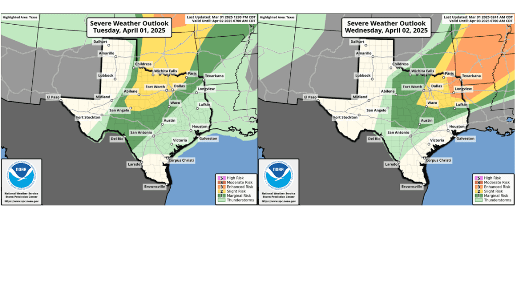
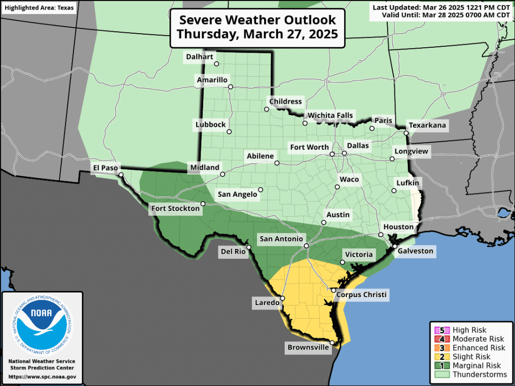
Tuesday night into Wednesday morning, there will be a chance for scattered rain showers and thunderstorms across the Hill Country and the northern half of Central Texas (including the Austin metro area) when a weak cold front sags southeast out of northwest Texas. The probability for rain will range from 40 percent across the northern Hill Country, to just 20 percent in the Austin area. The atmospheric setup near and south of the front appears somewhat favorable for some of the storms to become strong to severe. The Storm Prediction Center has placed the area along and west of a line stretching from just east of Waco, to Austin, to just north of San Antonio under a Marginal Risk, or a1 out of 5 risk, for severe thunderstorms Tuesday evening through 7 am Wednesday. Large hail and damaging winds will be the primary severe weather threats. For areas that happen to see rain, amounts are predicted to average less than a half inch.
A second and somewhat better chance for scattered showers and thunderstorms for the Hill Country and Central Texas regions is forecast to occur Wednesday night into Thursday morning when passing disturbance to our north will help spark the development of scattered showers and thunderstorms along and north of Tuesday’s stalled cold front. Once again, some of the thunderstorms may be strong to severe. The Storm Prediction Center has placed most of the Hill Country and the northern counties of Central Texas under a 1 out of 5 risk for severe thunderstorms through 7 am Thursday. For locations that happen to see rain, totals once again are forecast to average less than a half inch.
High temperatures Wednesday and Thursday are forecast to be warm, with highs in the upper 80s to 90 degrees. Lows Thursday and Friday mornings are predicted to be near 70-72 degrees.
A more widespread coverage of rain showers and thunderstorms is forecast to occur beginning Thursday night, when a large trough of low pressure starts to move to the east out of the western and southwestern U.S., dragging a Pacific cold front into the state. In advance of the front, warm and humid air will spread north from the Gulf. Scattered showers and thunderstorms are forecast to develop Thursday night, then increase in coverage Friday through Friday night. Additional periods of rain are forecast to continue into Saturday morning as the cold front slowly spreads east through the region. The majority of the rain is forecast to taper off from west to east midday Saturday through late Saturday afternoon as drier and a somewhat more stable air spreads in behind the cold front. However, a slight chance for a showers looks to continue Saturday night through midday Sunday as an area of weak atmospheric lift spreads in behind the cold front.
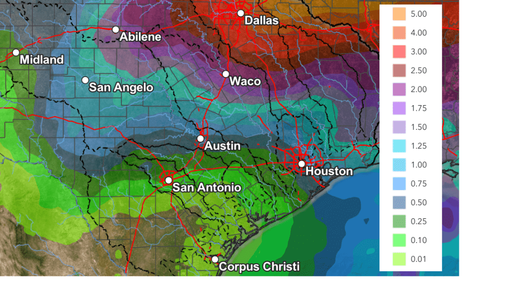
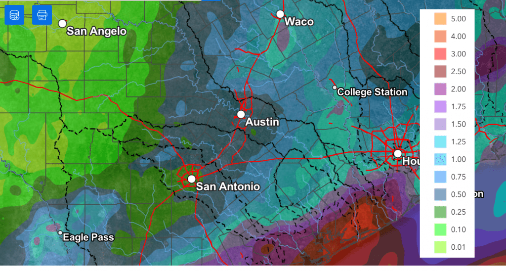
Rain amounts Thursday through Sunday are forecast to range from about 1-1.25 inches across the northern Hill Country, to near 0.5 to 1 inch around the Austin area, to between 0.25 and 0.5 inches across the coastal plains.
NWS Rainfall Forecast for Valid through 7 pm next Monday:
Cooler air will spread south across the area Saturday afternoon and Saturday night behind the cold front and remain in place through the middle of next week. Sunny and dry weather is forecast next Monday through Friday as weak ridge of high pressure sets up over the south central U.S.
- Lows Sunday morning are forecast to be in the mid-40s across the Hill Country, the upper 40s across Central Texas, with upper 50s near the coast
- High temperatures Sunday are predicted to be in the low 60s across the Hill Country and Central Texas regions, and in the upper 60s across the coastal plains
- Lows next Monday morning will include the low 40s across the Hill Country, the mid-40s across Central Texas, and upper 40s across the coastal plains
High temperatures Monday through Wednesday are forecast to be in the 70s. Lows Tuesday and Wednesday mornings will be in the 40s. Warmer temperatures will return next Thursday and Friday with highs returning to the 80s, with lows in the 50s.
Bob
Previous Blog Entries
Dry Weather Returning this Weekend, Continuing through the Middle of Next Week
Very moist air spreading north from the Gulf produced very beneficial rains across much of the area late Wednesday through Thursday night. While parts of the area saw totals of close to 2 inches, the highest totals from this rain event occurred across Deep South Texas, to the south of Laredo and Corpus Christi, where there were widespread 5 to 8 inch totals. Intense rains produced storm totals of 15-20 inches along the urban corridor between McAllen and Brownsville, resulting in catastrophic flash flooding.
NWS Estimate of Rain Falling Between 7 am Wednesday and 7 am Friday:
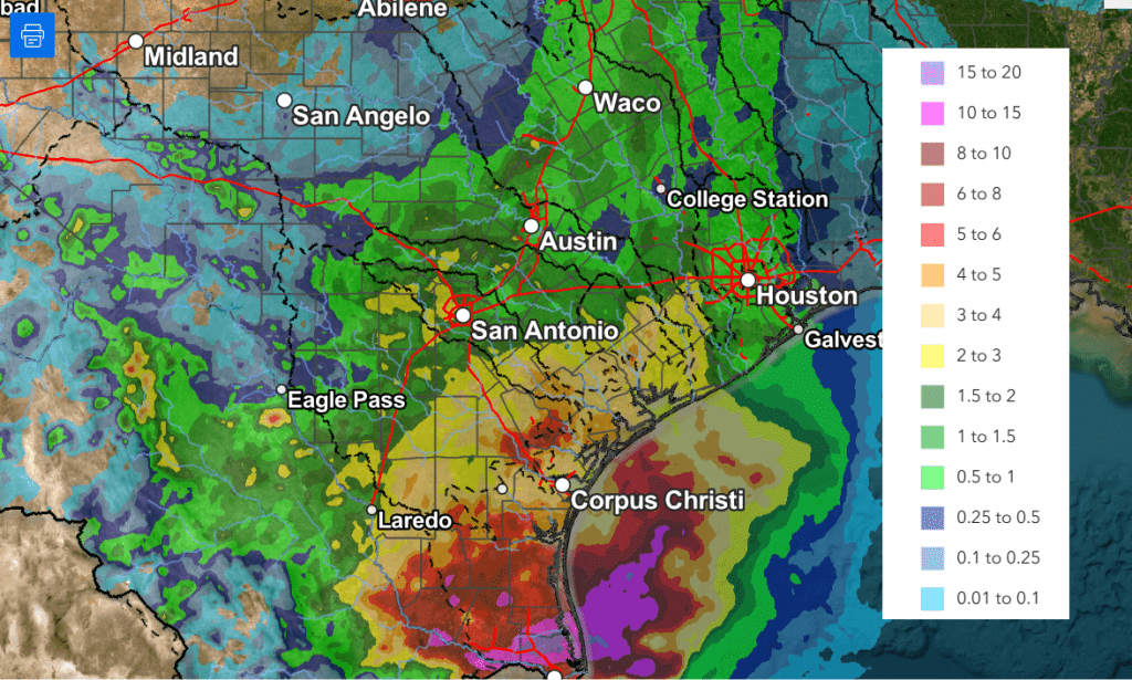
According to LCRA’s Hydromet, the lowest totals of rain over the past couple of days occurred across the northern and western Hill Country, generally west of a line stretching from Junction to San Saba. Totals through 9 am Friday across this area averaged less than a quarter inch. Across the remainder of the Hill Country and Central Texas, most totals averaged between 0.5 and 1 inch, with a few isolated heavier totals. Across the middle Texas coast, amounts generally averaged between 1 and 2.5 inches. The Bay City area in Matagorda County, appears to have received the most rain through 9 am Friday, with a total of 3.22 inches.
While additional rain is forecast Friday afternoon, the threat for heavy, flooding rain has diminished. Because of this, the National Weather Service has canceled the Flood Watch which had been posted for the middle Texas coast and parts of Central Texas. Widespread light to moderate rain and isolated thunderstorms are forecast from the eastern Hill Country, southeast to the Texas coast Friday afternoon as a trough of low pressure slowly moves east out of Central Texas.
- The probability for rain will range from 40 percent across the eastern Hill Country, to 70 percent across Central Texas, to 90 percent across the coastal region
- The chance for rain looks to diminish from west to east late Friday afternoon into Friday evening
- Additional rain amounts through Friday evening are forecast to average around a quarter inch or less across Central Texas, and between 0.5 and 1 inch across the coastal plains
A cloudy sky is forecast Friday night into Saturday morning. Clouds will decrease and the sky will become mostly sunny Saturday afternoon. A similar pattern of morning clouds and afternoon sunshine is forecast for Sunday. With the sunshine, the temperature is expected to be a bit warmer over the weekend.
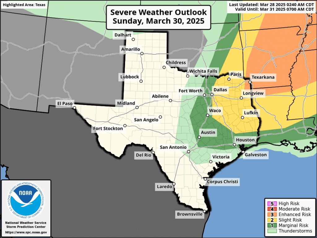
A trough of low pressure pushing northeast out of the southern Rockies on Sunday will help to push a cold front south through the Hill Country, Central Texas, and coastal region Sunday afternoon into Sunday night. While large-scale lift associated with trough is expected to remain north of our area, atmospheric conditions ahead of and along the cold front may support the development of a few widely scattered thunderstorms—mainly across the northeastern Hill Country and the northern half of Central Texas. The probability for rain will be 20 percent. Some of these storms could possibly become strong to severe. The Strom Prediction Center has placed these two areas under a Marginal Risk, or 1 out of 5 risk, for severe thunderstorms Sunday afternoon into Sunday night. The primary severe weather risks will likely be large hail and damaging winds.
- High temperatures Friday will generally be in the mid 70s
- Highs Saturday are forecast to be in the low and mid-80s
- High temperatures Sunday will generally be in the mid-80s, with upper 80s across the Hill Country
- Low temperatures Saturday and Sunday mornings are forecast to be in the low and mid-60s
- Lows Monday morning will range from the mid-50s across the Hill Country, to the mid and upper 60s near the coast
The first half of next week is shaping up to be mostly sunny and warm. Sunday’s cold front is predicted to move back to the north late Monday, allowing for a return of southerly winds and warmer temperatures.
- High temperatures are forecast to be in the upper 70s Monday, warming to the low and mid-80s Tuesday
- High temperatures Wednesday are predicted to be near 90-92 degrees, with upper 80s near the coast
- Lows will generally be in the upper 50s to mid-60s
The outlook for Thursday through next weekend, calls for more sunny and warm weather. However, there will be a slight chance for scattered afternoon and evening thunderstorms each day across the Hill Country and Central Texas regions as a series of weak troughs track move across the southern Plains. Significant or heavy rain is not expected. Forecasts point to a somewhat better chance for rain for the entire region around Monday, April 7th and 8th. No significant change in the temperature is forecast over the next ten days.
Have a good weekend!
Bob
Wet Pattern Will Continue through Friday Evening. Dry and Warmer this Weekend
A wet weather pattern continues across Central and South Texas. As of early Thursday afternoon, the highest totals of rain so far have occurred across Deep South Texas and the Coastal Bend regions, with much lower totals further recorded further to the north. The western half of the Hill Country had yet to receive any rain.
A widespread coverage of rain showers and scattered thunderstorms is forecast across the region Thursday evening and Thursday night, continuing through Friday afternoon as a large trough of low pressure pushes east out of northern Mexico. With a very moist air mass in place, showers and scattered thunderstorm activity is expected to increase as the upper trough pushes east into Texas. Waves of showers and thunderstorms are forecast to spread over the area Thursday night, continuing through Friday. Some of the rain may at times be locally heavy. The probability for rain will be near 50 percent across the Hill Country and near 90-100 percent across Central Texas and the middle Texas coast.
Thursday’s forecast model solutions continue to struggle with the location of the highest rain totals over the next 24 hours. It’s worth noting there’s been a general trend over the last few model runs for the highest totals of rain to continue to be across the Coastal Bend region and the middle Texas coast, with lower totals further inland. As a result, updated rainfall forecasts now call for lower rain totals for the Hill Country and Central Texas regions, compared to earlier forecasts.
Updated National Weather Service rainfall forecasts through late Friday afternoon call for totals of 0.25 to 0.5 inches across the western and central Hill Country, with totals of 0.5 to 1.25 inches across Central Texas. For the middle Texas coast, totals of 1-3 inches are forecast, with isolated amounts to near 5 inches possible.
NWS Rainfall Forecast Valid through 7 pm Friday:
A Flood Watch remains posted for Colorado, Wharton, and Matagorda Counties through Friday evening.
A very low-end threat for strong to severe thunderstorms will continue for most of the area through Friday afternoon. It will be possible an isolated thunderstorms or two could produce large hail and damaging winds. But a widespread severe threat is certainly not anticipated.
A chance for additional light rain showers will continue into Friday evening. However, the chance for rain is predicted to end from west to east late Friday evening and toward midnight as the upper trough finally exits to the northeast.
This weekend’s weather is forecast to be mostly sunny and warm, with high temperatures in the mid-80s. The next chance for rain is expected to occur late week when a new trough of low pressure tracks east from the southwestern U.S.
Bob
Significant Totals of Rain Forecast Thursday through Friday
…Widespread rain, possibly heavy at times, is expected across the region Wednesday night through Friday…
…A Flood Watch has been posted for Wharton and Matagorda Counties from Thursday morning through Friday afternoon…
The combination of a vigorous trough of low pressure moving east out of northern Mexico and a feed of deep moisture is expected to cause rounds of showers and thunderstorms across the region beginning Wednesday afternoon, continuing through Friday. While all areas will see beneficial rain, the highest totals over the next couple of days are predicted to occur across South Texas and the Coastal Bend area.
As of early Wednesday afternoon, Doppler radar showed scattered thunderstorms developing across South Texas, with the activity spreading to the north. This area of rain is associated with a small wave of low pressure out ahead of the main low pressure trough located over northern Mexico. High-resolution forecast solutions call for this current are of rain to spread north into parts of the Hill Country, Central Texas, and the middle Texas coast later this afternoon, continuing into Wednesday evening and Wednesday night.
The main trough of low pressure is forecast to track east from northern Mexico Thursday afternoon into Friday. The trough is expected to draw considerable moisture well inland from the Gulf. Thursday’s atmospheric setup appears quite favorable for waves of rain showers and thunderstorms to spread north across the region throughout the day and into Thursday night. Forecasts point to a very efficient rainfall processes, which could lead to some large amounts of rain occurring in a short period of time.
Additional widespread rain and scattered thunderstorms are forecast across the region on Friday as the upper trough slowly pushes east into Texas. The heaviest rain is predicted to fall over the area east of Interstate 35 –especially across the middle and upper Texas coast. The National Weather Service has posted a Flood Watch for areas south of Interstate 10, including Wharton and Matagorda Counties, through Friday afternoon.
The rain should taper off from west to east late Friday afternoon into Friday evening as the upper trough exits to the northeast.
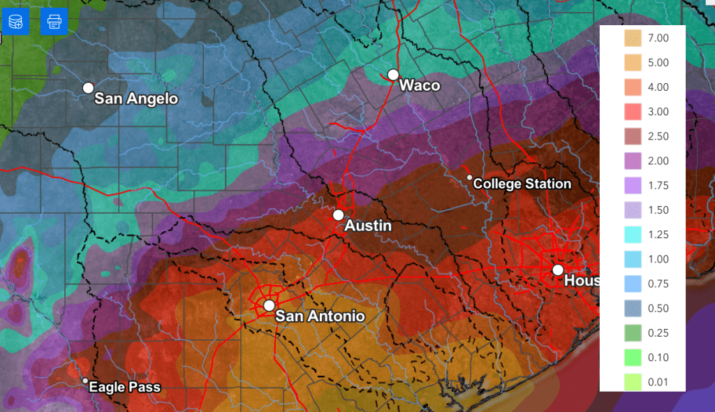
National Weather Service cumulative rainfall totals through Friday evening call for totals of 1-1.5 inches across the western half of the Hill Country, and totals of 2-4 inches across the eastern Hill Country and most of Central Texas. Totals of 3-5 inches are forecast across the middle Texas coast. Totals greater than 5 inches will be possible across the coastal plains region.
NWS Rainfall Forecast Valid through 7 pm Friday:
Rains Thursday into Friday have the potential to cause a localized flood threat across the Hill Country and Central Texas regions. There will be an increased threat for flooding and flash flooding for area along and south of Interstate 10, where higher amounts of rain are forecast.
There will also be some potential for a few strong to severe thunderstorms Thursday through Friday afternoon. The Storm Prediction Center has placed parts of the region under a Marginal Risk, or 1 out of 5 risk, for severe storms on both days. The primary severe weather risks will be large hail and damaging downburst winds.

I urge everyone to keep up with weather developments over the next couple of days. Have multiple ways of receiving watches and warnings from the National Weather Service.
Bob
Widespread Rain and Thunderstorms Forecast Thursday through Friday
Strong to severe thunderstorms developed in advance of a cold front Sunday evening across parts of the Hill Country and Central Texas. A few of the storms produced large hail and strong winds. The largest hail appears to have occurred across Kerr County, where hail up to 2.5 inches in diameter was observed. A few of the storms produced wind gusts of 30-45 mph. One of the strongest recorded gusts was 61 mph, at 9:46 pm, at Austin-Bergstrom International Airport. The storms all pushed well off to the east and southeast late Sunday night.
Drier and more stable air has spread into our area behind Sunday’s cold front. Thankfully, winds will be much lighter today through Wednesday, compared to what we’ve seen recently, so no elevated fire danger concerns are anticipated.
Sunny and quiet weather will be in place Monday afternoon and again on Tuesday. Winds will shift back to the southeast Monday night, allowing moisture and higher humidity levels to return to the middle Texas coast. Low clouds and patchy fog are forecast to develop across the coastal plains region late Monday night into Tuesday morning, but the clouds should burn off by midday Tuesday. Tuesday’s temperature is predicted to become unusually warm, thanks to abundant sunshine, light winds, and low relative humidity readings.
- Monday’s temperature is forecast to generally reach the mid-80s
- Lows Tuesday morning will generally be in the upper 50s to low 60s
- High temperatures Tuesday are forecast to be in the low 90s across the Hill Country and Central Texas regions, and into the upper 80s across the coastal plains
- Low temperatures Wednesday morning are predicted to be near 60-62 degrees
- High temperatures Wednesday are forecast to be in the mid to upper 80s
Wednesday’s weather will feature a partly cloudy sky as middle and high-level clouds spread over the area in advance of a Pacific trough of low pressure pushing inland along the northwestern coast of Mexico. Forecasts call for a few scattered thunderstorms to develop across the Rio Grande Plains and the western half of the Hill Country Wednesday afternoon and evening as the dry line pushes to the east out of Mexico.
An active, wet weather pattern is predicted for the entire region Thursday through Friday as the trough of low pressure over northern Mexico slowly tracks east-northeast, moving across Texas. This system is forecast to pull considerable moisture inland from the Gulf, increasing the likelihood for efficient rain-producing cells.
A slight chance for rain showers and isolated thunderstorms is forecast after midnight Wednesday night. This will be followed by a somewhat better chance for scattered rain showers and thunderstorms Thursday morning into Thursday afternoon. The probability for rain will be near 60-70 percent.
The best chance for rain looks to occur Thursday night through Friday afternoon when the trough of low pressure moves overhead. Periods of rain showers and scattered thunderstorms can be expected, with the probability for rain near 80 percent. The chance for rain is forecast to decrease to around 30 percent Friday evening and Friday night as the main trough begins to exit to the northeast.
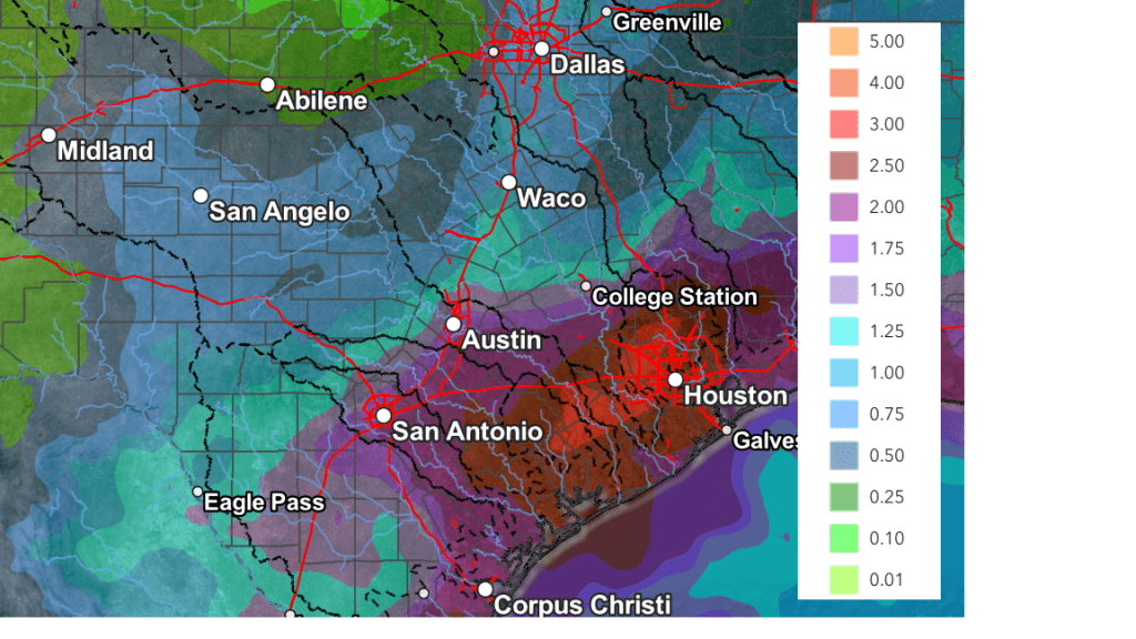
Rainfall forecasts call for widespread rain amounts of 0.5 to 1 inch on Thursday and on Friday, with pockets of higher totals for areas east of Interstate 35.
The National Weather Service’s cumulative rainfall forecast through Sunday evening shows the highest totals of rain occurring generally along and east of Interstate 35, where totals of 1 to 3 inches will be possible. Isolate totals in excess of 3 inches will be possible. Across the Hill Country, totals of 1-1.5 inches are forecast.
NWS Rainfall Forecast Valid through 7 pm Sunday:
Forecasts call for a 20-30 percent chance for mainly afternoon and evening showers and thunderstorms Saturday and Sunday as a second wave of low pressure tracks east across the southern Plains states.
Looking ahead to next week, mostly sunny, dry, and warm weather is forecast as a weak ridge of high pressure remains over the south central U.S. Some scattered thunderstorms will be possible across the Edwards Plateau and the western Hill Country late next week as the dry line becomes active once again. Daily high temperatures are forecast to be in the mid and upper 80s, with lows in the 50s to low 60s.
Have a great week!
Bob
A Chance for Rain Sunday Night. A Better Chance for Rain Expected Next Thursday and Friday
Friday started off rather chilly. LCRA’s Hydromet showed temperatures reached the mid-30s to low 40s across the Hill Country and Central Texas regions and the mid to upper 40s across the middle Texas coast. It’s interesting to note that many traditional low spots, including Austin-Bergstrom International Airport, recorded low temperatures in the upper 20s to low 30s. ABIA recorded a low of 32 degrees, while Austin-Camp Mabry recorded a low of 44 degrees.
The area of high pressure which brought the cool air into our region has moved off to the east, causing the return of southerly breezes. Wind speeds are predicted to increase to a range of 10-20 mph, with occasional gusts to 30 mph Friday afternoon into Friday evening as the pressure gradient strengthens. The air mass is currently quite dry across as low-level moisture will take some time to return off the Gulf. Minimum relative humidity levels are forecast to reach the teens to low 20 percent range Friday afternoon. The combination of the strong winds, low humidity levels, and dry vegetation is expected to cause elevated to near critical fire weather conditions across the entire region Friday afternoon. Any fires that happen to develop will spread quickly. All types of outdoor burning are not recommended!
Sunny and warmer weather is forecast Friday afternoon through Saturday. Wind speeds are predicted to decrease to 5-10 mph Friday night, but increase to 10-15 mph with gusts to 25 mph Saturday. Meanwhile, relative humidity levels are forecast to be higher Friday night through Saturday as low-level moisture slowly returns off the Gulf. The higher relative humidity levels should cause fire weather conditions to improve some on Saturday.
Fire Danger Forecast for Friday and Saturday (Texas A&M Forest Service):
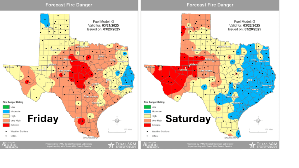
- High temperatures Friday are forecast to be in the mid and upper 70s
- Lows Saturday morning will generally be in the low 50s
- High temperatures Saturday are predicted to be in the low and mid-80s
- Lows Sunday morning are forecast to be in the low and mid-60s
- High temperatures Sunday are forecast to be in the mid-80s
A trough of low pressure moving east across the Plains on Sunday will help to a Pacific cold front across the Hill Country and Central Texas regions late Sunday afternoon into Sunday evening. The front is forecast move across the coastal plains region after midnight Sunday night. Ahead of the cold front, low-level moisture is expected to spread north from the Gulf, causing a partly cloudy sky. Forecasts indicate a few rain showers and isolated thunderstorms may accompany the cold front when it moves across the area Sunday evening and Sunday night. The probability for rain will be near 30-40 percent. Low rain amounts are forecast, with most totals averaging around a tenth of an inch or less.
NWS Rainfall Forecast for the Period 7 am Friday through 7 am Monday:

Quiet and warm weather is forecast for the first half of next week as a weak ridge of high pressure spreads over Texas. High temperatures Monday are forecast to be in the mid-80s. Highs Tuesday are forecast to be in the upper 80s to low 90s. Highs Wednesday are forecast to be in the mid and upper 80s.
Forecasts call for a temporary change in the persistent dry weather pattern late next week when a trough of low pressure is predicted to slowly track from northern Mexico eastward across Central and South Texas. This system is expected to pull considerable moisture north from the Gulf of Mexico and cause the development of widespread rain showers and scattered thunderstorms across a large part of Texas beginning Wednesday night, continuing Thursday through Friday. This will be very beneficial rain! National Weather Service rainfall forecasts are showing the potential for totals between 1 and 2 inches across Central and South Texas next Thursday through Friday. Cumulative totals of more than 2 inches will be possible over parts of the Hill Country and the Edwards Plateau.
NWS Rainfall Forecast for the Period 7 pm Wednesday through 7 pm Friday:

Dry and warm weather is forecast next weekend, continuing into the start of April.
Have a great weekend!
Bob
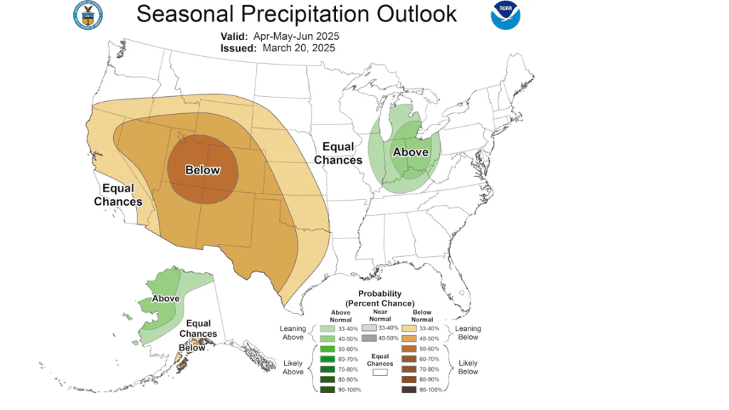
NOAA Releases its Spring Weather Outlook
The National Oceanic and Atmospheric Administration’s (NOAA) Climate Prediction Center released its outlook for spring Thursday, and for most of Texas, the outlook is not optimistic for significant rain and quite bullish for warmer than-normal temperatures.
CPC’s precipitation outlook for the Hill Country and Central Texas regions leans toward below normal rainfall (35 to 40 percent) and persisting drought conditions.
CPC’s temperature outlook calls for temperatures to average above normal across Texas (50 to 60 percent).
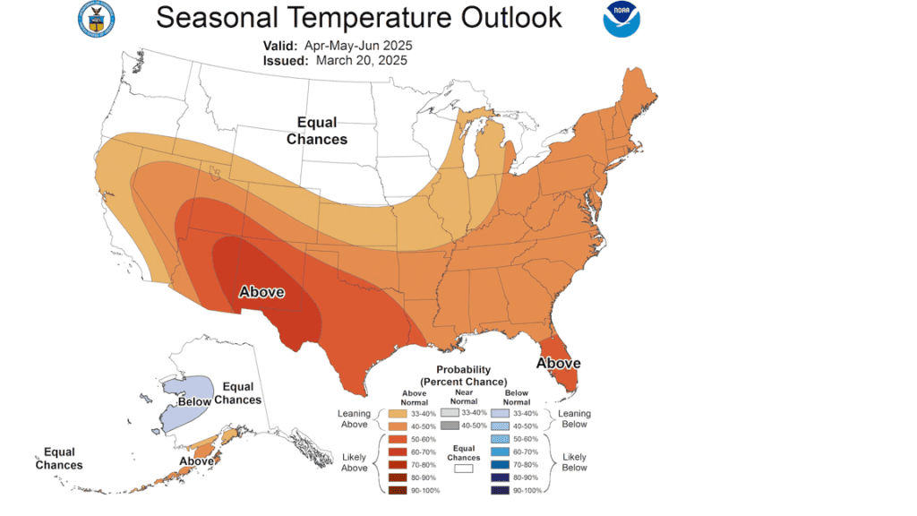
Forecasters behind the outlook indicated La Niña is weakening quickly and should fade away in April. However, La Nina’s typical winter pattern of below-normal rainfall across the southwestern U.S. is expected to hang on through much of spring. While several storm systems will likely move across the area into June, the most favorable area for rain is predicted to occur mainly from East Texas through the Deep South.
Thursday’s spring outlook coincides with one of the driest months of March on record. Monthly totals have generally only averaged about a quarter inch or less across the Hill Country, Central Texas, and coast regions.
Bob
Dry Pattern Continues Along with Elevated to Critical Fire Weather Conditions
No change to the current dry and warm weather pattern is expected this week across Texas. Forecasts call for the storm track to remain to the north of the state continuing into next week. At the same, only limited amounts of moisture will be able to spread north from the Gulf. This will result in continued sunny, dry, and breezy weather conditions stretching into next week. Unfortunately, elevated to critical fire weather conditions will continue—especially for areas located along and to the west of Interstate 35.
Monday through Wednesday
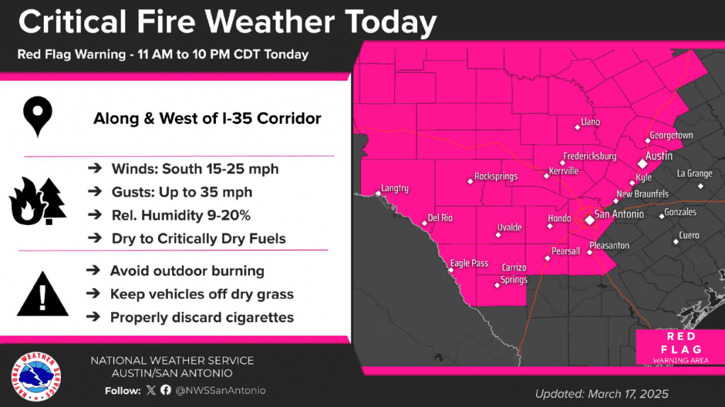
Developing low pressure across the southern Rockies Monday is creating a strengthening pressure gradient across the state. This will result in the development of breezy southerly winds of 10-20 mph, with gusts to near 30 mph Monday afternoon and Monday night. Despite winds being off the Gulf, very dry air is predicted to continue into Monday evening. Minimum relative humidity values are forecast to fall below 20 percent across the Hill Country and the Interstate 35 corridor Monday afternoon into Monday evening. This combination of gusty winds, very dry air, and critically to extremely dry fuels will create Critical Fire Weather conditions for areas along and west of Interstate 35. The National Weather Service has posted a Red Flag Warning for this general area through 10 pm Monday evening.
- High temperatures Monday are forecast to be in the low and mid-80s
- Lows Tuesday morning will be in the low and mid-50s
- High temperatures Tuesday are predicted to be in the mid-80s
- Lows Wednesday morning will be in the mid and upper 50s, with upper 60s expected towards the coast
- Highs Wednesday will range from the low 70s across the Hill Country, to the low 80s near the coast
Even stronger winds are forecast across the area Tuesday as the pressure gradient strengthens ahead of a storm system pushing east out of the southern Rockies. Gusts to near 40 mph are predicted for most of the region Tuesday afternoon into Tuesday evening. Relative humidity readings are forecast to be slightly higher—in the range of 15-25 percent. The strong wind and dry air will likely create more critical fire weather conditions for areas along and to the west of Interstate 35. The NWS indicates they may post another Red Flag Warning for this area on Tuesday.
Forecasts call for a cold to sweep southeast across the region late Tuesday night into Wednesday morning. No rain is expected with the front as most of the atmospheric dynamics will remain well north of our region. The front will bring drier and slightly cooler air. In addition, strong northerly winds with speeds of 15-25 mph and gusts to 30 mph can be expected Wednesday afternoon and evening. The combination of the strong winds and dry air will likely cause elevated to critical fire weather conditions in place across the entire region on Wednesday.
Wednesday through Saturday
Cooler air will spread across the area Wednesday night through Thursday. Milder air will begin returning Friday into Saturday. Lighter winds are forecast Thursday, which should help ease the fire threat temporarily. However, wind speeds are forecast to increase Friday and through the weekend. Elevated to critical fire weather conditions are forecast.
- Lows Thursday morning will include the upper 30s across the Hill Country, the low 40s across Central Texas, and the mid to upper 40s across the coastal plains
- High temperatures Thursday are forecast to be in the low 70s
- Lows Friday morning will be in the mid and upper 40s
- Highs Friday are forecast to be near 78-80 degrees
- Lows Saturday morning will be in the mid 50s
- High temperatures Saturday are forecast to be mid-80s
Sunday and Next Week
Forecasts call for a cold front to push southeast across the area Sunday afternoon into Sunday night. Unlike the past few fronts, a bit more moisture is forecast to return ahead of the front. This will result in a slight chance for a few rain showers and isolated thunderstorms along the cold front when it moves across the eastern Hill Country, Central Texas, and coastal regions. Rain amounts, are predicted to only be around a tenth of an inch.
Dry weather is forecast next Monday and Tuesday. Expect highs in the 80s, with lows in the 50s.
Another chance for rain is showing up for the middle of next week when a trough of low pressure moves over the area. Rain amounts are forecast to again only be around a tenth of an inch. Highs mid and late week are forecast to be in the 80s, with lows in the 50s and 60s.
First Day of Astronomical Spring
Astronomical spring, or the Vernal Equinox, begins on Thursday, March 20, 2025 at 4:01am CST. Near equal amounts of daylight and darkness will result.
Bob
A High Fire Danger through Saturday. Sunny and Dry Weather Forecast all of Next Week
…A Red Flag Warning has been posted Friday for West Texas, the Hill Country, and Central Texas…
…A Fire Weather Watch has been posted for the entire region Saturday ahead of additional critical fire weather conditions…
Weather Highlights
- Critical fire weather conditions will materialize across the Hill Country and Central Texas regions Friday afternoon due to very dry air and strong winds
- A Red Flag Warning has been posted through 9 pm Friday evening
- Critical fire weather conditions are predicted for the entire region Saturday due to continued dry air and strong winds
- A Fire Weather Watch has been posted for Saturday
- Fire weather conditions are forecast to improve Sunday into Monday
- Critical fire weather conditions will return next Wednesday when a Pacific front brings more dry and windy weather
- Sunny and dry weather is forecast Sunday, continuing through late next week
Discussion
Our weather over the next week is forecast to remain rain-free. Passing disturbances, unusually dry air, and strong winds will combine to produce several periods of elevated to critical fire weather conditions across the region. Unfortunately, no significant rain is on the weather horizon.
A trough of low pressure lifting northeast of new Mexico Friday afternoon is expected to help pull the dry line from West Texas eastward across the Hill Country and into Central Texas. Forecasts call for the dry line to move into the Interstate 35 corridor early to mid-afternoon Friday, then slowly continue moving to the east late Friday afternoon into Friday evening. Behind the dry line, relative humidity values are forecast to fall below 20 percent. Meanwhile, a strong pressure gradient associated with the trough of low pressure is expected to cause surface winds to become quite strong Friday afternoon.
- Wind speeds across the Hill Country are forecast to be in the range of 20-30 mph, with gusts to 45 mph
- Wind speeds across Central Texas are forecast to be in the range of 15-25 mph, with gusts to 35 mph
- Wind speeds across the middle Texas coast are forecast to be in the range of 10-20 mph, with gusts to 30 mph
The strong winds and very dry air will combine to produce critical fire weather conditions Friday afternoon. The National Weather Service has posted a Red Flag Warning for the Hill Country and Central Texas regions through 9 pm Friday evening. Fire weather conditions are not expected to be quite as extreme for areas south of Interstate 10 due to slightly higher relative humidity readings.
Areas of blowing dust will be possible across the Hill County and Central Texas regions Friday afternoon and evening. The National Weather Service has posted a Blowing Dust Advisory for the western and northern Hill country through 8 pm Friday evening. Under a mostly sunny sky, Friday’s temperature is forecast to reach the low and mid-80s across the Hill Country, and the upper 80s to low 90s across the rest of the region.
Friday night, the dry line is forecast to merge with a Pacific cold front and slowly push east across the coastal plains. Wind speeds across the region are forecast to decrease around 10-15 mph late Friday evening through Friday night. Lows Saturday morning will include the low and mid-50s across the Hill Country and Central Texas regions, and the low to mid-60s coastal region.
Interestingly, there will be a slight chance (20 percent chance) for the development of a few isolated thunderstorms after midnight Friday for areas along and east of Interstate 35 when a second trough of low pressure tracks east across northern Texas. This system is forecast to be quite dynamic, but it will be starved for moisture. Nevertheless, it could initiate a couple of isolated thunderstorms over the area. Should any storms happened to develop, they may contain rain and small hail.
Saturday’s weather will be mostly sunny and slightly cooler as the second trough exits to the east. Expect high temperatures in the upper 70s. However, very dry air with relative humidity values below 20 percent are forecast to be in the place across the entire region by Saturday afternoon. A moderate to strong pressure gradient behind the departing trough is expected to keep wind speeds strong Saturday afternoon through Saturday evening. Expect westerly winds with speeds of 15-25 mph and occasional gusts to 40 mph. The combination of the very dry air and strong winds is expected to cause critical fire weather conditions. As a result, the NWS has posted a Fire Weather Watch for the entire region for Saturday. A Fire Weather Watch is issued when the combination of dry fuels and weather conditions support extreme fire danger. The Fire Weather Watch may be upgraded to a Red Flag Warning on Saturday. Fire weather conditions should improve by midnight Saturday night as wind speeds decrease to 5-10 mph.
Fire Danger Outlook from the Texas A&M Forest Service:

Sunny, dry, and less windy weather is forecast Sunday into Monday. High temperatures are predicted to be in the upper 70s Sunday, and in the low and mid-80s Monday. Lows Monday morning are forecast to be in the mid and upper 40s. Lows Tuesday morning look to be in the mid and upper 50s.
Another high fire danger period is forecast to develop Wednesday when a Pacific trough of low pressure moves from the Great Basin to the southern Plains states. This system is expected to push another dry Pacific cold front across the state next Wednesday. Wind speeds are predicted to increase to 15-25 mph Tuesday afternoon through Wednesday afternoon. Critical fire weather conditions are expected to develop across the region Wednesday as drier air spreads in behind the cold front.
High temperatures are forecast to be in the low 80s next Wednesday, cooling into the low 70s Thursday. Highs are predicted to warm back to the low and mid-80s by next weekend.
Forecasts remain quite pessimistic for any significant rain developing through the end of the month.
Bob
A Very High Fire Danger Wednesday
…Critical to extreme fire weather conditions are forecast to develop across West Texas, the Hill Country, and the Austin/Interstate 35 corridor this afternoon and evening…
…Any fires developing today could be very difficult to control and will likely spread rapidly…
A dry line currently situated across West Texas is forecast to shift east this morning through the afternoon hours, bringing extremely dry air. Relative humidity values are forecast to fall below 15 percent behind the dry line. Meanwhile, strong winds of 20-30 mph with gusts to near 45 mph are predicted to develop across West Texas and expand east across the Hill Country through the afternoon. The combination of the very dry air, strong winds, and dormant vegetation will set the stage for critical to extreme fire weather conditions.
The National Weather Service has posted a Red Flag Warning for all of West Texas, the Hill Country, and the Interstate 35 corridor between Temple, Austin, San Antonio, and Pearsall, from noon until 9 pm Wednesday evening.
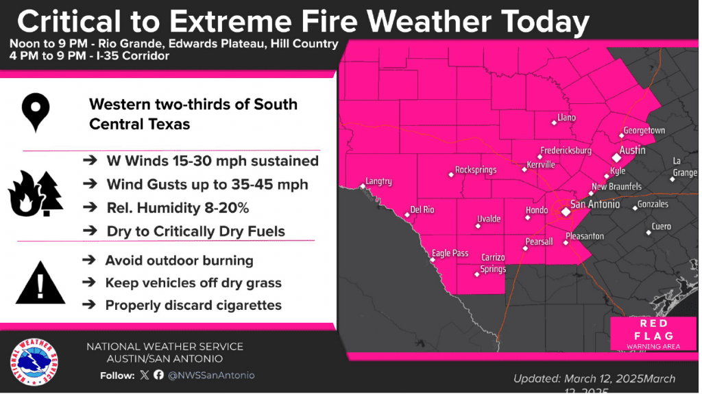
Forecasts call for the windy conditions and the very dry air to spread east across the Hill Country this afternoon. The dry and windy conditions are forecast to reach the Interstate 35 corridor sometime late this afternoon, continuing through the early evening hours.
The extreme fire weather conditions should begin to abate around mid-evening as wind speeds decrease to 10-15 mph, with occasional gusts to 25 mph.
For areas located to the east of Interstate 35, the threat for critical to extreme weather will not be as high today due higher relative humidity values and somewhat lighter winds. But with dry conditions in place, fire weather conditions here will still be elevated.
Everyone is urged to limit outdoor activities today that might ignite a fire. These include avoiding any sort of outdoor burning, keeping vehicles off of dry grass, and properly discarding all cigarettes.
Another period of critical fire weather conditions appears to be coming together across the area for Friday into Saturday as strong winds and dry air develop once again.
Bob
Social Media