The persistent warm and dry weather pattern we’ve seen for most of April will finally begin to change this weekend and next week as an approaching trough of low pressure brings our region a chance for rain and scattered thunderstorms. This will be followed by additional chances for rain and storms next Tuesday through Friday. Parts of the Hill Country are forecast to receive between 1 and 2 inches of rain over the next seven days.
Friday’s weather is expected to be warm and breezy, with a partly to mostly cloudy sky. A strong pressure gradient across the state is expected to cause strong southerly winds with speeds of 10-20 mph and occasional gusts to 35 mph. It will be a warm day, with the temperature warming up to 88-90 degrees.
There will be a slight chance for the development of some scattered thunderstorms across the Hill Country region late Friday night as a small wave of low pressure pushes east out of West Texas. High resolution forecasts call for scattered thunderstorms to develop across The Concho Valley region late Friday evening, with the storms slowly pushing east-northeast across the Hill Country after midnight and toward daybreak on Saturday. There remains some uncertainty as to the amount of thunderstorm coverage across the Hill Country late Friday night as the storms will be moving into a fairly stable atmosphere. The probability for storms across the Hill Country late Friday night will be near 30 percent. Should the storms survive, they are predicted to remain sub-severe. For Central Texas and the middle Texas coast, breezy and warm conditions are forecast overnight, with lows near 70 degrees.
There will be a 30-40 percent chance for scattered rain showers and thunderstorms across the Hill Country and Central Texas regions Saturday morning through Saturday afternoon as another wave of low pressure begins to push east out of West Texas. At the same time, the atmosphere over the region is predicted to become quite moist and less stable. There will be a small chance an isolated thunderstorms or two across the Hill Country could become strong to severe Saturday afternoon. Severe weather threats will include large hail and damaging winds. Saturday’s weather will be mostly cloudy, breezy, and warm. Look for winds to gust to near 30 mph with high temperatures generally in the mid-80s.
The most favorable period for rain showers and thunderstorms over the weekend is predicted to occur Saturday night into Easter Sunday when a large trough of low pressure tracks northeast across the Texas Panhandle, pushing a Pacific cold front southeast into the Hill Country and Central Texas. Forecasts call for an area of showers and thunderstorms to develop across the Concho Valley and Big Country regions in advance of and along the cold front Saturday night.
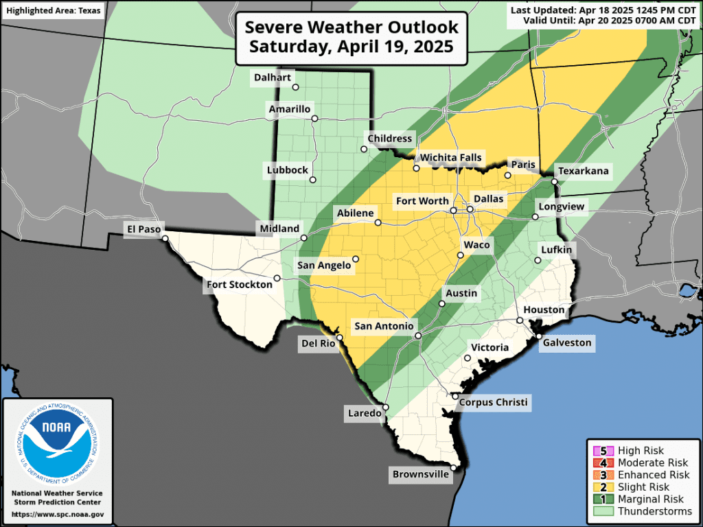
The area of rain and storms is predicted to spread into Hill Country by about midnight Saturday night, with the area of rain continuing to spread to the east and southeast. Atmospheric condition may support some of the thunderstorms to be strong to severe. The Storm Prediction Center has placed the area west of Interstate 35 under a Slight Risk, or a 2 out of 5 risk, for severe thunderstorms through 7 am Sunday. The primary severe weather threats will be large hail and damaging winds. The rain activity is predicted to taper off from west to east Sunday morning. Expect a partly cloudy sky Sunday afternoon.
The area of rain and thunderstorms is forecast to shift to the Interstate 35 corridor and Central Texas near, or just after sunrise Sunday morning. The area of thunderstorms is forecast to be weakening as it exits the Hill Country and spread into Central Texas. The threat for severe storms is expected to be fairly low. The rain and thunderstorm activity is forecast to taper off from northwest to southeast Sunday morning as the cold front moves to the southeast. Expect a partly cloudy sky Sunday afternoon.
For the middle Texas coast, showers and scattered thunderstorms are forecast to spread into the area Sunday morning and continue Sunday afternoon and Sunday evening as the cold front slows down and stalls near the coast. The probability for rain will be near 70 percent, decreasing to 50 percent Sunday night.
High temperatures Easter Sunday are forecast to be in the upper 70s to low 80s.
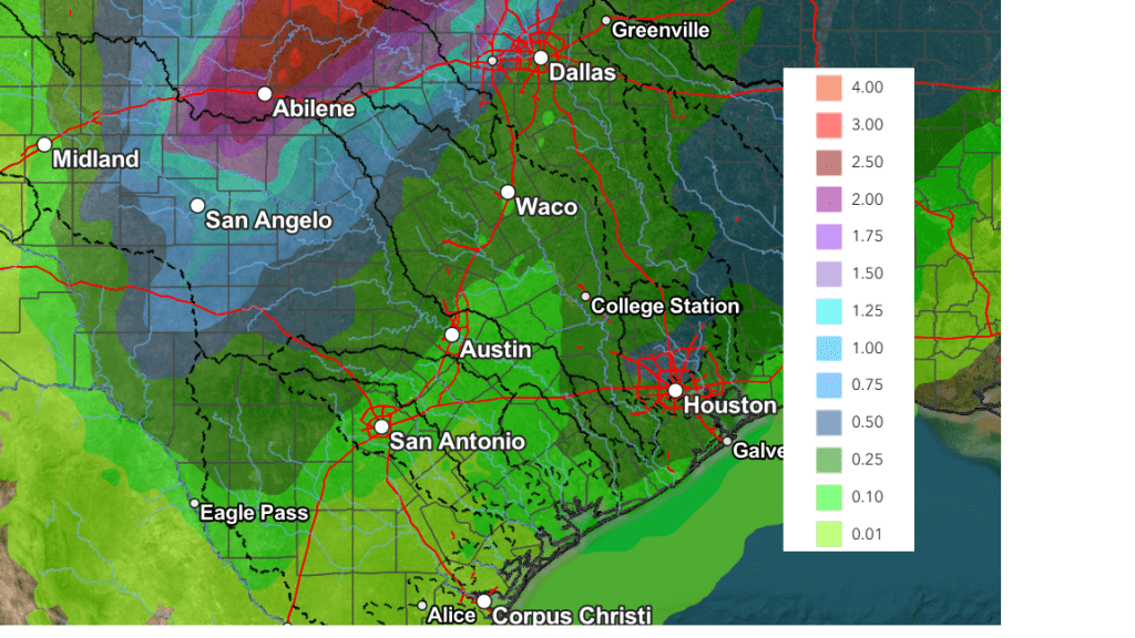
Rain amounts through Monday morning are forecast to average between 0.25 and 0.5 inches across the Hill Country, and close to close to a quarter inch across Central Texas and the middle Texas coast.
Severe Weather Outlook for Saturday and the NWS Rainfall Forecast Valid through 7 pm Monday
Monday’s weather is expected to be mostly sunny across the Hill Country and Central Texas region. Meanwhile, there will be a 40-50 percent chance for scattered rain showers for the middle Texas coast where the front remains stalled. Rain amounts are forecast to be around a quarter inch.
The outlook for next Tuesday through Friday calls for a 40-50 percent chance for rain showers and scattered thunderstorms across the entire region as a series of low pressure troughs move over Texas out of the southwestern U.S. and northern Mexico. Daily rain amounts of 0.25 to 0.5 inches are forecast. The latest data shows the thunderstorm activity remaining below severe threshold.
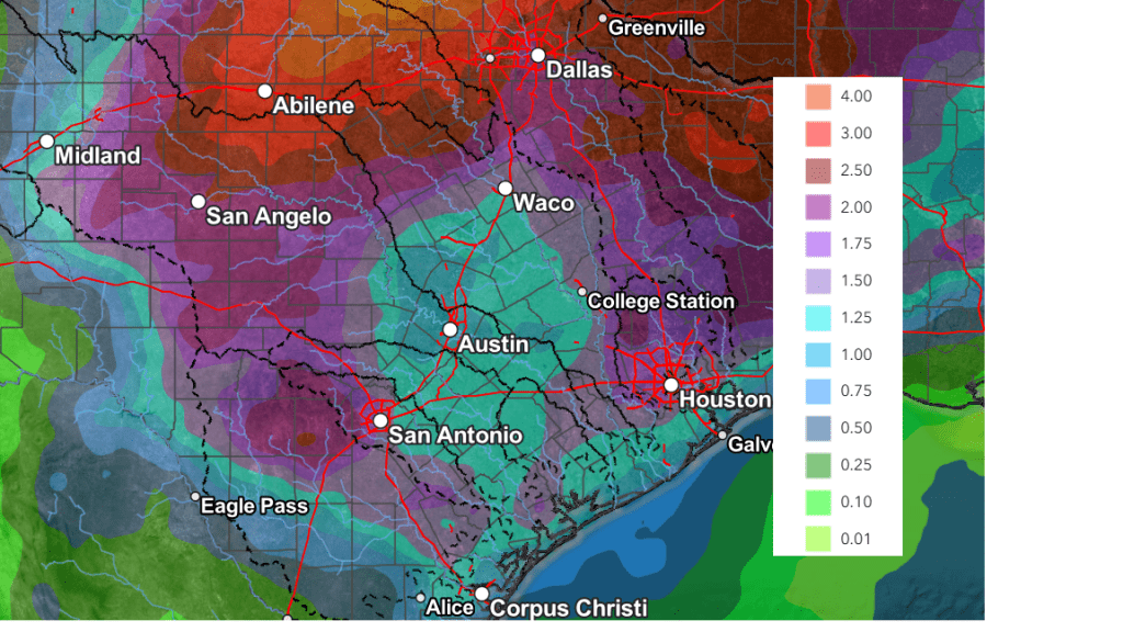
National Weather Service forecasts call for rain amounts over the next seven days to total between 1 and 1.5 inches across the Hill Country, and between 0.5 and 1.25 inches across Central Texas and the middle Texas coast.
NWS Rainfall Forecast Valid through 7 pm Next Friday:
High temperatures next week are forecast to be mostly in the low and mid-80s.
Looking out a little further, dry weather is forecast to return next weekend, but the long-range solutions are indicating another chance for rain returning to the forecast around the beginning of May.
Have a great weekend!
Bob
Social Media