Dry and quiet weather conditions are forecast through late week as our region remains under the stable influence high pressure situated over the south central U.S. and northern Mexico. Some changes to the weather pattern are expected this weekend and next week as the ridge slides off to the east, allowing for a more unsettled weather pattern to take shape. A chance for rain will finally return to the forecast.
A trough of low pressure pushing east across the northern Plains states is helping to push a weak cold front south into Texas. As of early Monday afternoon, the front stretched from Sherman to Abilene, to near Fort Stockton. The front is predicted to slowly move south across the Hill Country and Central Texas regions after midnight Monday night, then pull up stationary along the middle and upper Texas coast Tuesday morning. Unfortunately, the atmosphere will be too dry for the development of any rain along the front. The front is expected to bring slightly cooler temperatures for Tuesday and Tuesday night before warmer air returns on Wednesday. Ahead of the front, more unseasonably warm readings are forecast.
- High temperatures Monday are predicted to be in the low and mid-90s across the Hill Country and Central Texas regions, and in the mid-80s across the coastal plains
- Lows Tuesday morning will generally be around 60-62 degrees
- High temperatures Tuesday will include the upper 70s across the Hill Country, the low 80s across Central Texas, and the low to mid-80s towards the coast
- Low temperatures Wednesday morning will range from the mid-50s across the Hill Country, to the low 60s near the coast
Mostly sunny, breezy, and warmer weather can be expected Wednesday through Friday as the cold front lifts back to the north. This will allow warm and more humid air to spread north from the Gulf. Expect southerly breezes each day of 10-15 mph, with occasional gusts to around 35 mph.
- High temperatures Wednesday will be in the low and mid-80s, warming to the mid and upper 80s for Thursday and Friday
- Lows Thursday and Friday mornings are forecast to be in the low and mid-60s
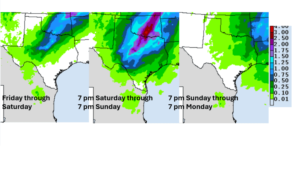
Changes to the stationary weather pattern will finally begin to take place this weekend when the ridge over Texas moves to the east. At the same time, a large trough of low pressure is predicted to move into the western and southwestern U.S. out of the Pacific. Forecasts call for the large trough to track east across the southern Plains and northeast to the Great Lakes this weekend and early next week. The low is expected to pull considerable Gulf moisture north into Texas beginning late Friday, continuing through the weekend. This will result in a mostly cloudy sky. While the main trough is forecast to pass north of Texas, small weaker troughs of low pressure are forecast to move across the state over the weekend, helping to cause a chance for scattered rain showers and thunderstorms. Additional chances for scattered rains look to extend into the early and middle parts of next week as well as more weak disturbances move over the region.
Forecasts call for a 30 to 40 percent chance for rain and thunderstorms Saturday and Saturday night, increasing to a 40 to 50 percent Sunday through early next week. The highest totals of rain are forecast to occur across the northern Hill Country and the northern counties of Central Texas, with the lowest totals to the south.
NWS Rainfall Forecast for Saturday, Sunday, and Monday:
NWS Cumulative Rainfall Valid through 7 pm Monday:
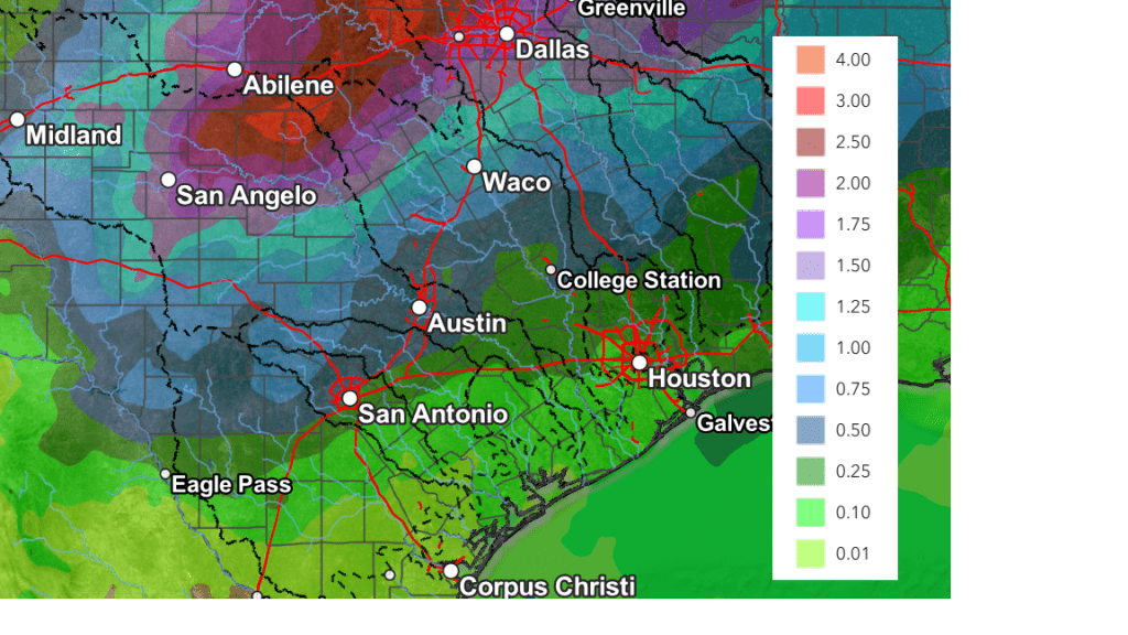
Scattered showers and thunderstorms through the first half of next week will have the potential to cause scattered daily totals in the range of 0.25 to 0.5 inches.
The outlook for late next week into the following weekend calls for generally dry weather and warm temperatures, with highs in the mid-80s.
Have a good week!
Bob
Social Media