Monday started off unusually cool, with the temperature dipping into the 30s as far south as Interstate 10. According to LCRA’s Hydromet, lows were generally in the mid-30s across the Hill Country, in the upper 30s across Central Texas, and in the low to mid-40s across the middle Texas coast. It is interesting to note there were a fair number of Hill Country locations that did see the temperature fall to, or below freezing. The Hydromet’s lowest recorded temperature was 26 degrees near Fort McKavett, in eastern Schleicher County. Close to Austin, the temperature fell to 28 degrees along Cow Creek near Lago Vista, in northwestern Travis County. Austin’s official low temperature was 39 degrees at both Camp Mabry and Austin-Bergstrom International Airport. San Antonio recorded a low of 40 degrees.
A dry and very stable weather pattern is now in place across Texas as the system responsible for Saturday’s rainy/cold weather shifts to the East Coast. Forecasts call for a ridge of high pressure currently covering southern California and northwestern Mexico to spread east this week and into the upcoming weekend. This feature will keep our weather sunny and rain-free throughout the week. At the surface, light northeasterly winds are forecast to continue this afternoon and tonight. However, southerly breezes will return on Tuesday, causing warmer temperatures that will likely stick around for the remainder of the week. Southerly breezes are forecast to increase to 10-15 mph, with gusts to 25 mph on Wednesday.
A weak, dry cold front is predicted to push south through the area Thursday afternoon and Thursday night. The front will mainly cause the wind to shift out of the north with speeds of 10-20 mph and gusts to 30 mph Thursday afternoon and Thursday night. The front is not expected to bring any appreciable change to the temperature late week or this weekend.
- High temperatures Monday are forecast to be around 68-72 degrees
- High temperatures Tuesday are predicted to be in the upper 70s, warming to the lower 80s on Wednesday
- High temperatures Thursday and Friday are forecast to be in the mid-80s
- Weekend high temperatures are predicted to be in the upper 80s
- Low temperatures Tuesday morning look to be around 40 degrees across the Hill Country, and in the low 40s at most other locations
- Lows Wednesday morning are predicted to be in the low 50s
- Lows Thursday and Friday mornings are forecast to be in the mid and upper 50s
- Lows Saturday and Sunday mornings are predicted to be in the upper 50s to low 60s.
Looking out into next week, forecast solutions call for a trough of low pressure to move into the Four Corners region early next week, with the trough slowly lifting east-northeast into the southern Plains states next Wednesday and Thursday. Only a modest return of Gulf moisture is expected out ahead of the trough. Forecast solutions call for a slight chance for rain across the area the middle of next week as a Pacific cold front associated with the trough moves across Texas. Rain amounts, if any, are forecast to average less than a quarter inch.
Temperatures look to stay warm next week, with highs well into the 80s, and lows in the 60s.
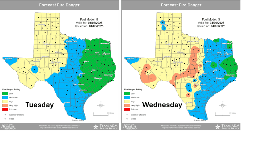
Fire Weather Concerns Returning Wednesday and through the Weekend
Elevated fire weather concerns are forecast to develop across the Edwards Plateau and much of the Hill Country Wednesday through Monday as relative humidity values fall to the teens and 20th percentile each of those days.
The Texas A&M Forest Service Fire Danger Forecast maps show the increase fire danger starting Wednesday:
Have a good week!
Bob
Social Media