Showers and scattered thunderstorms are forecast to develop across the Hill Country and Central Texas regions Friday afternoon, but the main round of strong to severe thunderstorms will come Friday night into Saturday morning when a trough of low pressure and Pacific cold front push to the east out of West Texas. The area of rain and storms is expected to spread across the middle Texas coast.
For Friday afternoon, expect a mostly cloudy sky across the region. There will be 30-40 percent chance for scattered rain showers and thunderstorms across the Hill Country and Central Texas regions as the atmosphere becomes a bit more unstable in advance of a large trough of low pressure pushing east from northern Mexico and southern Arizona. Most of the storm activity Friday afternoon is expected to remain below severe thresholds. High temperatures Friday will range from low and mid-70s across the northern Hill Country, to the low 80s across Central Texas, to the upper 80s towards the coast.
Moving into Friday evening, additional scattered rain showers and isolated thunderstorms are forecast across the Hill Country and Central Texas regions as the atmosphere becomes increasingly unstable. Some of these thunderstorms may be strong to severe.
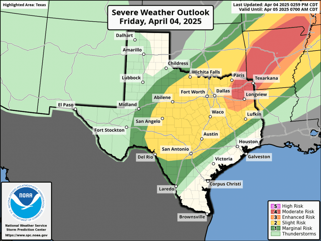
The most favorable period for rain showers and thunderstorms is expected to take place after midnight Friday night when a Pacific cold front pushes east out of West Texas and the Edwards Plateau. High resolution forecasts call for a large area of showers and thunderstorms to develop along the cold front across Edwards Plateau around midnight, with the showers and storms spreading east across the Hill Country, the Interstate 35 corridor, and parts of Central Texas between midnight and 6 am. Some of these thunderstorms may be strong to severe. The primary severe weather threats will be large to significant hail of 2 inches in diameter or greater, and damaging wind gusts of 60 mph. In addition to the severe weather threats, pockets of heavy rain will also be possible. The Storm Prediction Center has placed the Hill Country and most of Central Texas under a Slight Risk, or a 2 out of 5 risk, for severe thunderstorms through 7 am Saturday. Behind the main area of rain and thunderstorms, lighter rains and a couple of isolated thunderstorms look to continue till about midday Saturday.
For the eastern counties of Central Texas and the middle Texas coast, the leading edge of the showers and thunderstorms is forecast to spread across the area beginning shortly after daybreak and continue Saturday morning through Saturday afternoon. There is a chance for some of these thunderstorms to also be strong to severe. Similar to areas to the west, the primary severe weather threats will be large hail and damaging winds. The Storm Prediction Center has placed easter Colorado, Wharton, and Matagorda Counties under a 2 out of 5 risk for severe thunderstorms on Saturday. A transition to mostly light showers and isolated thunderstorms is predicted for late Saturday afternoon and early Saturday evening.
The Storm Prediction Center’s Severe Weather Outlook for Friday and Saturday:
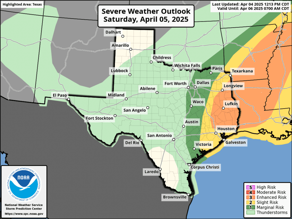
The rain is forecast to taper off from west to east across the Hill Country and Central Texas regions Saturday afternoon. Across the coastal plains, the rain should taper off by late Saturday evening.
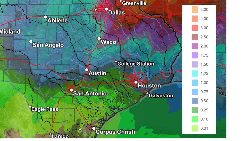
Projected rain amounts from Friday afternoon through Saturday evening continue to call for totals of 1-1.5 inches across the Hill Country, around 1 inch across Central Texas, and between 0.25 and 0.5 inches for areas south of Interstate 10.
NWS Rainfall Forecast Valid through 7 pm Sunday:
A rather strong Canadian cold front is forecast to push south through the area Saturday evening and Saturday night, bringing breezy and much colder air! In fact, this looks to be an unusually cold air mass for early April and it looks to last into the middle of next week. Plan to drag the coats and jackets back out of the closet. Expect northwesterly winds at 15-20 mph, with gusts to near 30 mph to develop Saturday night and continue through Sunday afternoon. Wind speeds should decrease Sunday night into Monday morning. The sky is forecast to be partly to mostly cloudy Sunday, followed by a clear sky on Monday.
Sunday night into Monday morning is shaping up to be the coldest period of the next few days.
A light freeze looks possible over parts of the Hill Country Monday morning!
- Low temperatures Sunday morning are forecast to be in the low and mid-40s across the Hill Country and Central Texas regions, and into the upper 40s across the coastal plains
- Low temperatures Monday morning are predicted to be in the low and mid-30s across the Hill Country, into the upper 30s across Central Texas, and into the low and mid-40s across the coastal plains
- Lows Tuesday morning are forecast to be in the low 40s across the Hill Country and Central Texas regions and in the mid-40s towards the coast
- Lows Wednesday morning will generally be in the upper 40s to low 50s
High temperatures are forecast to be in the 50s to low 60s Sunday, warming to the 70s Monday and Tuesday. Highs will move back into the 80s next Wednesday through Friday.
A sunny and dry weather pattern will be in place all of next week, continuing into next weekend. The next chance for rain is not expected until just after the middle of the month.
Have a great Weekend!
Bob
Social Media