For Thursday into Thursday evening, weather conditions are expected to be partly cloudy and quiet. Expect breezy southeasterly winds with occasional gusts to 25 mph.
Scattered thunderstorms are forecast to develop across parts of West Texas and the Concho Valley late this evening and toward midnight when a trough of low pressure pushes east out of West Texas. This area of thunderstorms is then forecast to spread over parts of the Hill Country and possibly as far east as the Austin/Interstate 35 corridor Thursday night and toward daybreak Friday. Some of these storms, should they develop, may be strong to marginally severe. The primary severe weather threat will be large hail. The probability for storms is forecast to be near 50 percent across the Hill Country, and only near 20 percent in the Austin area and the Interstate 35 corridor.
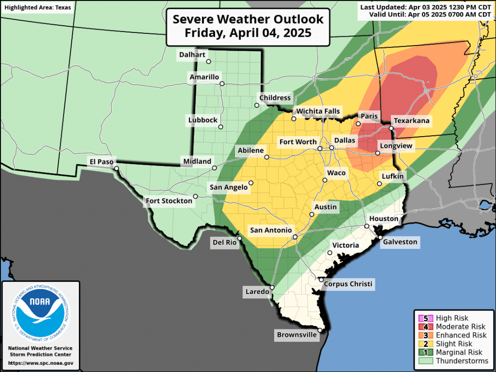
Attention will then turn to Friday afternoon and Friday night when a large trough of low pressure over Arizona begins moving to the east, helping to push a Pacific cold front east across Texas. High resolution forecasts indicate the atmosphere across the Hill Country and Central Texas regions ahead of the cold front will become fairly moist and moderately unstable. This is expected to lead to the development of scattered strong to severe thunderstorms. The primary severe weather threats will be large hail and damaging winds.
The Storm Prediction Center has placed all of the Hill Country plus the Austin/Interstate 35 corridor under a Slight Risk, or a 2 out of 5 risk, for severe thunderstorms Friday into Friday night. The eastern half of Central Texas has been placed under a 1 out 5 risk for severe thunderstorms. The probability for rain and storms Friday is predicted to be near 50-60 percent.
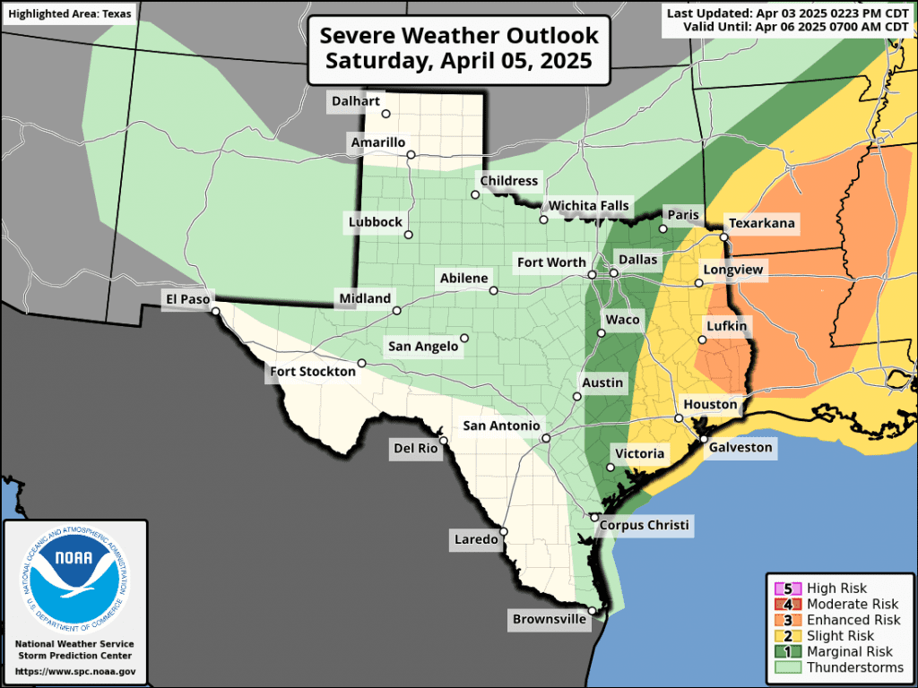
The Pacific cold front is forecast to slowly push to the east Friday night and is expected to reach the I-35 corridor around daybreak Saturday. The front will continue to move east to the coast Saturday morning into Saturday afternoon. Widespread rain showers and scattered thunderstorms are forecast to spread across the Hill Country and Central Texas regions along and behind the cold front Friday night into Saturday morning. Rain and scattered thunderstorms are predicted to spread across the middle Texas coast Saturday morning through Saturday afternoon.
The rain is forecast to taper off from west to east midday Saturday through late Saturday afternoon.
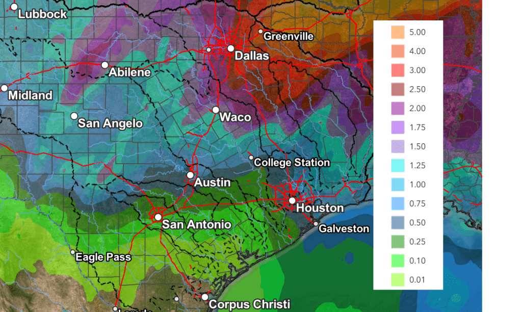
Rain amounts through Saturday are expected to be heaviest across the Hill Country, where totals of 1-1.5 inches are forecast. Totals of 0.5 to 1 inch are forecast across Central Texas. For the middle Texas coast, totals are forecast to be between 0.25 and 0.5 inches.
NWS Rainfall Forecast Valid through 7 pm Sunday:
Dry weather and much cooler weather will follow the cold front Saturday night into the first half of next week. I’ll have more details on this in Friday’s update.
CSU Forecasters Predict An Active 2025 Atlantic Hurricane Season
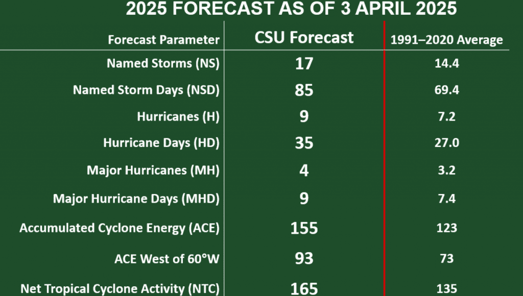
Another unusually active Atlantic hurricane season is likely in 2025. In their first seasonal forecast of 2025 Thursday, the Colorado State University hurricane forecasting team, led by Phil Klotzbach, called for 17 named storms, 9 hurricanes, and 4 major hurricanes. This is higher than the 1991-2020 long-term averages of 14.4 named storms, 7.2 hurricanes, and 3.2 major hurricanes. Last year’s season produced 18 named storms, 11 hurricanes, and 5 major hurricanes.
The CSU forecast used a statistical model that has been honed from more than 40 years of past Atlantic hurricane statistics, plus dynamical model output from four different model groups.
La Niña conditions in the Eastern Pacific have been weak in recent months, and most models are either forecasting neutral or weak La Niña conditions for the peak of the Atlantic hurricane season. In addition, sea surface temperatures are much warmer than average in the western and central Atlantic and eastern subtropical Atlantic. Meanwhile, waters in the eastern tropical Atlantic are near to slightly below average. in the eastern tropical Atlantic. According the CSU team, the enhanced warmth in the eastern subtropical Atlantic and in the Caribbean correlates well with what is typically seen in April before active Atlantic hurricane seasons.
Bob
Social Media