Strong to severe thunderstorms developed in advance of a cold front Sunday evening across parts of the Hill Country and Central Texas. A few of the storms produced large hail and strong winds. The largest hail appears to have occurred across Kerr County, where hail up to 2.5 inches in diameter was observed. A few of the storms produced wind gusts of 30-45 mph. One of the strongest recorded gusts was 61 mph, at 9:46 pm, at Austin-Bergstrom International Airport. The storms all pushed well off to the east and southeast late Sunday night.
Drier and more stable air has spread into our area behind Sunday’s cold front. Thankfully, winds will be much lighter today through Wednesday, compared to what we’ve seen recently, so no elevated fire danger concerns are anticipated.
Sunny and quiet weather will be in place Monday afternoon and again on Tuesday. Winds will shift back to the southeast Monday night, allowing moisture and higher humidity levels to return to the middle Texas coast. Low clouds and patchy fog are forecast to develop across the coastal plains region late Monday night into Tuesday morning, but the clouds should burn off by midday Tuesday. Tuesday’s temperature is predicted to become unusually warm, thanks to abundant sunshine, light winds, and low relative humidity readings.
- Monday’s temperature is forecast to generally reach the mid-80s
- Lows Tuesday morning will generally be in the upper 50s to low 60s
- High temperatures Tuesday are forecast to be in the low 90s across the Hill Country and Central Texas regions, and into the upper 80s across the coastal plains
- Low temperatures Wednesday morning are predicted to be near 60-62 degrees
- High temperatures Wednesday are forecast to be in the mid to upper 80s
Wednesday’s weather will feature a partly cloudy sky as middle and high-level clouds spread over the area in advance of a Pacific trough of low pressure pushing inland along the northwestern coast of Mexico. Forecasts call for a few scattered thunderstorms to develop across the Rio Grande Plains and the western half of the Hill Country Wednesday afternoon and evening as the dry line pushes to the east out of Mexico.
An active, wet weather pattern is predicted for the entire region Thursday through Friday as the trough of low pressure over northern Mexico slowly tracks east-northeast, moving across Texas. This system is forecast to pull considerable moisture inland from the Gulf, increasing the likelihood for efficient rain-producing cells.
A slight chance for rain showers and isolated thunderstorms is forecast after midnight Wednesday night. This will be followed by a somewhat better chance for scattered rain showers and thunderstorms Thursday morning into Thursday afternoon. The probability for rain will be near 60-70 percent.
The best chance for rain looks to occur Thursday night through Friday afternoon when the trough of low pressure moves overhead. Periods of rain showers and scattered thunderstorms can be expected, with the probability for rain near 80 percent. The chance for rain is forecast to decrease to around 30 percent Friday evening and Friday night as the main trough begins to exit to the northeast.
Rainfall forecasts call for widespread rain amounts of 0.5 to 1 inch on Thursday and on Friday, with pockets of higher totals for areas east of Interstate 35.
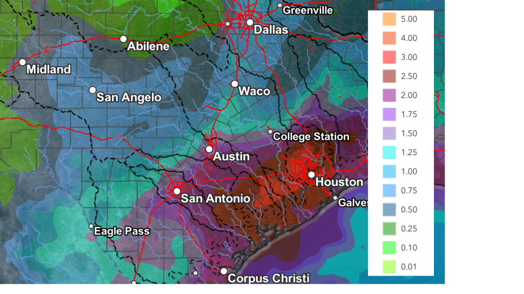
The National Weather Service’s cumulative rainfall forecast through Sunday evening shows the highest totals of rain occurring generally along and east of Interstate 35, where totals of 1 to 3 inches will be possible. Isolate totals in excess of 3 inches will be possible. Across the Hill Country, totals of 1-1.5 inches are forecast.
NWS Rainfall Forecast Valid through 7 pm Sunday:
Forecasts call for a 20-30 percent chance for mainly afternoon and evening showers and thunderstorms Saturday and Sunday as a second wave of low pressure tracks east across the southern Plains states.
Looking ahead to next week, mostly sunny, dry, and warm weather is forecast as a weak ridge of high pressure remains over the south central U.S. Some scattered thunderstorms will be possible across the Edwards Plateau and the western Hill Country late next week as the dry line becomes active once again. Daily high temperatures are forecast to be in the mid and upper 80s, with lows in the 50s to low 60s.
Have a great week!
Bob
Social Media