A Very High Fire Danger Wednesday
March 12, 2025
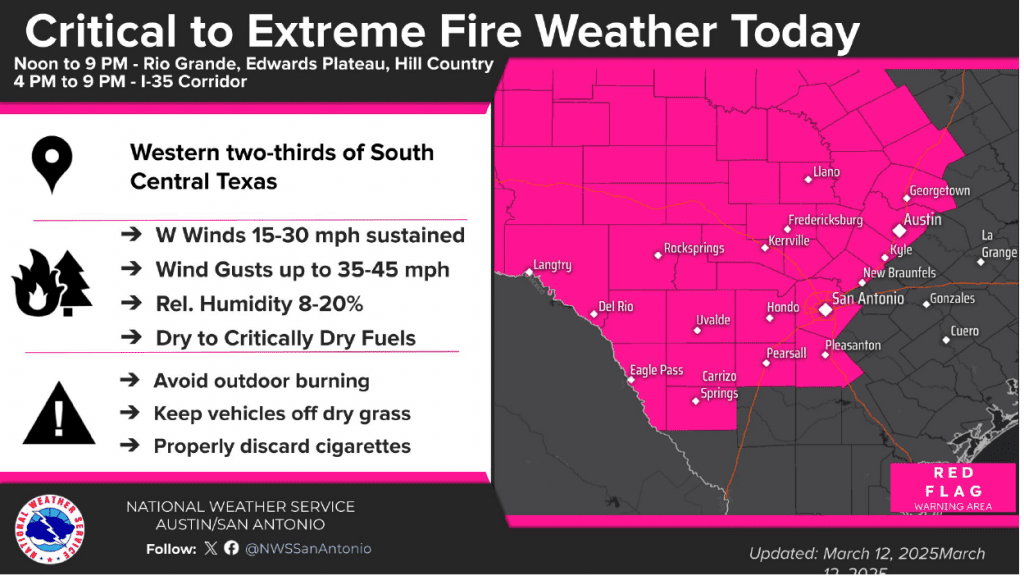
…Critical to extreme fire weather conditions are forecast to develop across West Texas, the Hill Country, and the Austin/Interstate 35 corridor this afternoon and evening…
…Any fires developing today could be very difficult to control and will likely spread rapidly…
A dry line currently situated across West Texas is forecast to shift east this morning through the afternoon hours, bringing extremely dry air. Relative humidity values are forecast to fall below 15 percent behind the dry line. Meanwhile, strong winds of 20-30 mph with gusts to near 45 mph are predicted to develop across West Texas and expand east across the Hill Country through the afternoon. The combination of the very dry air, strong winds, and dormant vegetation will set the stage for critical to extreme fire weather conditions.
The National Weather Service has posted a Red Flag Warning for all of West Texas, the Hill Country, and the Interstate 35 corridor between Temple, Austin, San Antonio, and Pearsall, from noon until 9 pm Wednesday evening.
Forecasts call for the windy conditions and the very dry air to spread east across the Hill Country this afternoon. The dry and windy conditions are forecast to reach the Interstate 35 corridor sometime late this afternoon, continuing through the early evening hours.
The extreme fire weather conditions should begin to abate around mid-evening as wind speeds decrease to 10-15 mph, with occasional gusts to 25 mph.
For areas located to the east of Interstate 35, the threat for critical to extreme weather will not be as high today due higher relative humidity values and somewhat lighter winds. But with dry conditions in place, fire weather conditions here will still be elevated.
Everyone is urged to limit outdoor activities today that might ignite a fire. These include avoiding any sort of outdoor burning, keeping vehicles off of dry grass, and properly discarding all cigarettes.
Another period of critical fire weather conditions appears to be coming together across the area for Friday into Saturday as strong winds and dry air develop once again.
Bob
Social Media