Weather Highlights
- Very cold temperatures and low wind chills will continue through Thursday
- There will be a low chance for some very light freezing rain or freezing drizzle across the eastern Hill Country and the Austin/Interstate 35 corridor late Friday night into early Saturday
- Light rain showers are forecast to develop on Saturday and continue into Sunday morning
- Milder temperatures are predicted for next week
Discussion
Arctic air quickly spread south across the region late Tuesday, bringing strong winds and much colder temperatures. By sunrise Wednesday, the temperature had fallen into the teens across the Hill Country, the low 20s across Central Texas, and the mid-20s to low 30s across the coastal plains. Some very light snow flurries developed across parts the region Wednesday morning, but there was no accumulation. The light snow all ended by midday Wednesday and no additional precipitation is expected.
Clouds will slowly thin across the region Wednesday afternoon. This will be followed by a generally clear sky Wednesday night through Thursday afternoon. The sky is forecast to become mostly cloudy on Thursday. The arctic air is forecast to remain in place into Saturday, then move off to the east on Sunday.
The wind is expected to remain strong and gusty into Thursday. Expect wind speeds of 10-15 mph with gusts to 25/30 mph Wednesday afternoon through Thursday afternoon. Wind speeds are predicted to decrease to around 5-10 mph Thursday night, continuing into Friday.
A recap of temperatures into the weekend:
- High temperatures Wednesday will range from about 30-32 degrees across the Hill Country, to the low and mid 30s across Central Texas, to the upper 30s across the coastal area
- Low temperatures Thursday morning are forecast to be between 10 and 15 degrees across the Hill Country, between 17 and 20 degrees across Central Texas, and in the mid to upper 20s across the coastal region
- High temperatures Thursday will range from the mid and upper 30s across the Hill Country, to the mid-40s near the coast
- Low temperatures Friday morning will range from the low 20s across the Hill Country, to the low 30s across the coastal region
- High temperatures Friday will be in the upper 30s to low 40s
- Lows Saturday morning will range from around 28-30 degrees across the Hill Country, to the low and mid-30s across Central Texas, to the upper 30s across the coastal plains
- High temperatures Saturday are forecast to be in the mid-40s to the low 50s.
- Lows Sunday morning are forecast to generally be in the upper 30s to low 40s.
For Friday and into the weekend, Wednesday’s forecast solutions have shown a few changes. The trough of low pressure which had been forecast to quickly track east across the southern Plains on Saturday is now predicted to move a little slower than previously forecast. Only some very light rain is predicted to develop across the region Friday night into Saturday morning. A better chance for rain (40-50 percent) is now forecast to develop across the region Saturday afternoon, continuing Saturday night into Sunday morning. The rain is forecast to end from west to east Sunday afternoon.
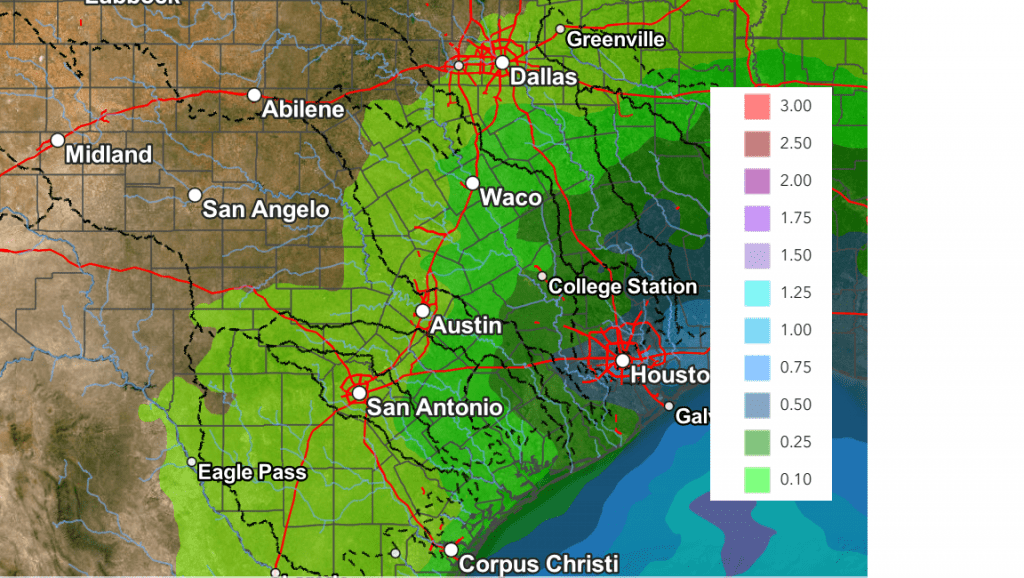
The eastern Hill Country and the Austin/I-35 corridor could see some very light/spotty freezing rain or freezing drizzle early Saturday morning, but with the systems slower movement, conditions could very well stay dry while the temperature is below freezing. There will be a 40-50 percent chance for precipitation across the region Saturday afternoon through Sunday morning. With the temperature above freezing, this precipitation should be all liquid. Rain amounts through Sunday are forecast to average less than a tenth of an inch across the Hill Country, less than a quarter inch across Central Texas, and less than a half inch across the coastal plains.
NWS Rainfall Forecast Valid through 6 pm Monday:
Warmer temperatures are forecast all of next week, with daily highs in the 70s.
Bob
Social Media