The spring-like weather pattern we’ve been experiencing this week looks to continue into the weekend. But changes in the pattern will be taking place Sunday into Monday that will bring cooler/colder temperatures and chances for rain to the forecast for next week. In fact, the Hill Country could see a light free next Wednesday night. While this week’s weather has felt much like April, keep in mind it is still February.
Mild and humid weather continues across the region thanks to a moderate wind flow off the Gulf of Mexico. Widespread low clouds Friday morning are forecast to burn off with the sky become mostly sunny Friday afternoon. A similar pattern of morning clouds and afternoon sunshine is forecast for Saturday. Warm temperatures are forecast on both Friday and Saturday, but Saturday’s temperature is expected to be the warmest, thanks to an area of warm, sinking air spreading east out of Mexico.
- High temperatures Friday are forecast to be in the low and middle 80s
- High temperatures Saturday are predicted to be in the mid to upper 80s
- Low temperatures Saturday morning will range from the low 60s across the Hill Country, to the upper 60s across the coastal plains
- Low temperatures Sunday morning are forecast to be in the mid and upper 50s across the Hill Country, in the low to mid-60s across Central Texas, and in the mid to upper 60s near the coast
A trough of low pressure pushing east across the Plains states is expected to push a weak cold front south into Texas late Saturday into Sunday. Forecasts call for the front to reach the northern Hill Country around midnight Saturday night and the Austin area shortly after sunrise on Sunday. The front is predicted to slow its southward momentum Sunday, reaching the coastal plains region not until sometime Sunday evening or Sunday night. Unfortunately, no rain is forecast along or behind the cold front. Expect a partly cloudy sky Sunday, with the sky becoming mostly cloudy Sunday night.
- High temperatures Sunday are forecast to be in the upper 60s to low 70s across the Hill Country, in the mid and upper 70s across Central Texas, and in the low 80s across the coastal plains
- Low temperatures Monday morning will include the upper 40s to low 50s across the Hill Country, the low and mid-50s across Central Texas, and the low 60s across the coastal plains
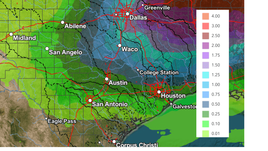
Monday’s weather is shaping up to be generally cloudy and cool as a weak overrunning pattern develops in advance of approaching trough of low pressure located over the southwestern U.S. Forecasts call for the trough to track east-northeast across Texas on Tuesday. An area of light to moderate rain showers are forecast to develop across the Hill Country and Central Texas regions Monday night, with showers and isolated thunderstorms continuing Tuesday morning into Tuesday afternoon. For the coastal region, showers and scattered thunderstorms are forecast to develop early Tuesday morning and continue through late Tuesday afternoon. The rain is forecast to taper off from west to east late Tuesday afternoon as the upper trough exits to the northeast. Rain amounts are forecast to generally average around a quarter inch.
Another chance for rain showers is forecast to develop across the region next Wednesday into Wednesday evening when a second trough of low pressure pushes east across the state. Rain amounts from this system are forecast to average around a tenth of an inch.
Total rain amounts Tuesday through Wednesday are forecast to generally average between a quarter and a half inch across the Hill Country and Central Texas regions, with lower amounts expected towards the coast.
NWS Rainfall Forecast for the Period 6 pm Friday through 6 pm Wednesday:
A very slight chance for rain is forecast next Thursday as yet another weak trough of low pressure moves over the area. However, rain amounts are predicted to only average a few hundredths of an inch.
Mostly sunny and dry weather is predicted for next Friday, continuing into next weekend.
The temperature will be noticeably cooler next week. A fairly strong cold front is forecast to bring a brief shot of some rather chilly air into the region next Wednesday into Thursday. Milder readings will follow next Friday and next weekend.
- High temperatures are predicted to be in the 60s Monday and Tuesday, cooling to the 50s on Wednesday and Thursday.
- Lows Wednesday morning are forecast to be in the low and mid-40s
- Lows Thursday morning are forecast to be in the low 30s across the Hill Country, in the low to mid-30s across Central Texas, and the upper 30s across the coastal plains
- Lows Friday morning are predicted to be in the low and mid-40s
Have a great weekend!
Bob
Social Media