Weather Highlights:
- Very cold air will arrive late Saturday and remain across the area through next Thursday
- Windy conditions will develop Saturday evening and persist into Tuesday. Expect gusts to near 30 mph.
- Readings close to 20 degrees are forecast across the entire region Tuesday night into Wednesday morning
- There is now medium confidence in the threat for wintery precipitation, mainly in form of snow, for the eastern Hill Country, Central Texas, and coastal areas late Monday through midday Tuesday
Discussion
Forecasts continue to call for an outbreak of arctic air into Texas this weekend, with the cold remaining in place through late next week. Friday’s data doesn’t show any significant change in the magnitude of the cold air headed our direction. Hard freezes are forecast across the entire region Sunday, Monday, Tuesday, and Wednesday nights. Monday and Tuesday nights are shaping up to be the coldest nights of the week. Preparations for the cold air should be rushed to completion Friday afternoon and Saturday morning.
Friday morning, the leading edge of the unusually cold air mass was located over southwestern Canada, about 300 miles north of US/Canadian border. The very cold air will plunge to the south Friday afternoon into Saturday and will begin to be felt Saturday evening when readings begin to fall through the 40s.
Winds behind the cold front are forecast to increase to a range of 10-15 mph, with occasional gusts to 30/35 mph. The windy conditions are forecast to persist Sunday into Monday as additional arctic air continues to spill into Texas.
The combination of the strong winds and the very cold air is expected to produce wind chill temperatures in teens Sunday, Monday, and Tuesday mornings.
Sunny and dry weather is forecast Saturday and Sunday. Clouds are predicted to increase across the area Monday afternoon and remain overcast Monday night into Tuesday afternoon. (More on the threat for precipitation below). Clouds are forecast to clear Tuesday afternoon, followed by a sunny sky next Wednesday.
A update on low temperatures forecast through late next week:
- Sunday morning: Low and mid-20s Hill Country, upper 20s Central Texas, and lower 30s coastal area
- Monday morning: Near 20 degrees across the Hill Country, in the low 20s across Central Texas, mid and upper 20s coastal plains
- Tuesday morning: Low 20s Hill Country, mid-20s across Central Texas, and upper 20s coastal plains
- Wednesday morning: A low near 20-22 across the entire region
- Thursday morning: Mid and upper 20s Hill Country and Central Texas regions, and near 30-32 degrees coastal plains
The disagreement among the forecast solutions discussed yesterday changed with the Thursday night model runs. The majority of the forecast guidance has now come into general agreement regarding the trough of low pressure moving across Texas late Monday, and moisture returning inland ahead of the trough. While the solutions all call for a threat for wintery precipitation, there is still some disagreement as to just how much precipitation will fall.
Initially, a mixed area of precipitation consisting of rain/freezing rain and sleet is forecast to develop across the coastal plains region, generally along and south of Intestate 10, Monday evening. The area of precipitation is predicted to change over to mostly snow across this area after midnight Monday night. To the north, forecasts call for an area of mostly light snow to develop Monday evening and Monday night across Central Texas, extending west into the eastern Hill Country. The light snow is forecast to continue into Tuesday morning, with the precipitation ending by midday Tuesday.
The probability for precipitation will be near 40 percent across the eastern Hill Country and all of Central Texas, while the probability for precipitation is forecast to be near 60 percent across the coastal plains.
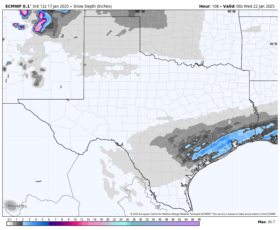
Snow accumulations through midday Tuesday are forecast to be less than an inch across the Hill Country and most of Central Texas. Snow and ice accumulations may actually be higher (greater than an inch) across the coastal plains region where moisture will be more plentiful.
Pasted below is the forecast accumulation of snow from the Friday morning European forecast solution. I would use this as a guide to where the precipitation is forecast to fall and a feel for the different magnitudes of snow possible. Again, this is not an official forecast and just an idea from one of the forecast solutions. This forecast has the potential to change over the next couple of days.
Forecast snow depth through noon Tuesday from the ECMWF model:
 Milder temperatures are forecast late next week into next weekend.
Bob


Social Media